AutoCAD Map 3D Forum
Welcome to Autodesk’s AutoCAD Map 3D Forums. Share your knowledge, ask questions, and explore popular AutoCAD Map 3D topics.
cancel
Showing results for 
Show  only  | Search instead for 
Did you mean: 

Calling Map Experts......

11 REPLIES 11
SOLVED
Reply
Message 1 of 12
neilyj666
759 Views, 11 Replies

Calling Map Experts......

Can someone take a look at this http://forums.autodesk.com/t5/autocad-civil-3d-general/calling-map-experts/td-p/5440416 and advise if there is any thing that can be done with the  data?

neilyj (No connection with Autodesk other than using the products in the real world)
Did you find this post helpful? Feel free to Like this post.
Did your question get successfully answered? Then click on the ACCEPT SOLUTION button.

EESignature


AEC Collection 2025 UKIE (mainly Civil 3D UKIE and IW)
Win 11 Pro x64, 1Tb Primary SSD, 1Tb Secondary SSD
64Gb RAM Intel(R) Xeon(R) W-11855M CPU @ 3.2GHz
NVIDIA RTX A5000 16Gb, Dual 27" Monitor, Dell Inspiron 7760
11 REPLIES 11
Message 2 of 12
antoniovinci
in reply to: neilyj666

Would you please upload here those shapefiles..?

We're gonna have a look at 'em, thx.

Message 3 of 12
neilyj666
in reply to: antoniovinci

Here's the zip - my ultimate aim is to have a series of points with a depth value at a spacing of 20-25m so I can bring it into Civil 3D as a surface for further manipulation......

neilyj (No connection with Autodesk other than using the products in the real world)
Did you find this post helpful? Feel free to Like this post.
Did your question get successfully answered? Then click on the ACCEPT SOLUTION button.

EESignature


AEC Collection 2025 UKIE (mainly Civil 3D UKIE and IW)
Win 11 Pro x64, 1Tb Primary SSD, 1Tb Secondary SSD
64Gb RAM Intel(R) Xeon(R) W-11855M CPU @ 3.2GHz
NVIDIA RTX A5000 16Gb, Dual 27" Monitor, Dell Inspiron 7760
Message 4 of 12
neilyj666
in reply to: antoniovinci

Here's the zip - my ultimate aim is to have a series of points with a depth value at a spacing of 20-25m so I can bring it into Civil 3D as a surface for further manipulation......


....don't know why it's double posted

neilyj (No connection with Autodesk other than using the products in the real world)
Did you find this post helpful? Feel free to Like this post.
Did your question get successfully answered? Then click on the ACCEPT SOLUTION button.

EESignature


AEC Collection 2025 UKIE (mainly Civil 3D UKIE and IW)
Win 11 Pro x64, 1Tb Primary SSD, 1Tb Secondary SSD
64Gb RAM Intel(R) Xeon(R) W-11855M CPU @ 3.2GHz
NVIDIA RTX A5000 16Gb, Dual 27" Monitor, Dell Inspiron 7760
Message 5 of 12
olivier.eckmann
in reply to: neilyj666

Hi,


1. create a classical array of point covering the area with space between row and column =21

2. export to SHP

3. connect via FDO your SHP point and your Peat_data

4. FDO Overlay with copy PD_cm

5. exclude Point without information from Peat_data

6. Add calculated field to transform PD_cm to the midlle value

7. export from SDF overlayed with the calculated filed to SHP or anything Civil could use as XYZ value


Olivier

Message 6 of 12
neilyj666
in reply to: olivier.eckmann

Thanks for this Olivier - you make it sound easy but I'm lost at step 1....

neilyj (No connection with Autodesk other than using the products in the real world)
Did you find this post helpful? Feel free to Like this post.
Did your question get successfully answered? Then click on the ACCEPT SOLUTION button.

EESignature


AEC Collection 2025 UKIE (mainly Civil 3D UKIE and IW)
Win 11 Pro x64, 1Tb Primary SSD, 1Tb Secondary SSD
64Gb RAM Intel(R) Xeon(R) W-11855M CPU @ 3.2GHz
NVIDIA RTX A5000 16Gb, Dual 27" Monitor, Dell Inspiron 7760
Message 7 of 12
olivier.eckmann
in reply to: neilyj666

Hi,


1. draw a point at coordinates X = 235841.0000     Y = 603273.0000  which correspond to X,Y min of your polygon + 3.5,3.5 offset in X et Y corresponding to hal of a "pixel" (7m*7m)

2. launch ARRAYCLASSIC  command, specify 367 rows, 244 columns, X spacing = 21, Y spacing = 21, select your point and press OK to draw the 89000 point representing a grid covering all your area

3. You can erase rapidly points which are outside of the polylgon, then lanch command MAPEXPORT, select SHP, check POINT in data type, select the layer in which you've drawn your points, and OK


I join the result of process.


Olivier

Message 8 of 12
neilyj666
in reply to: olivier.eckmann

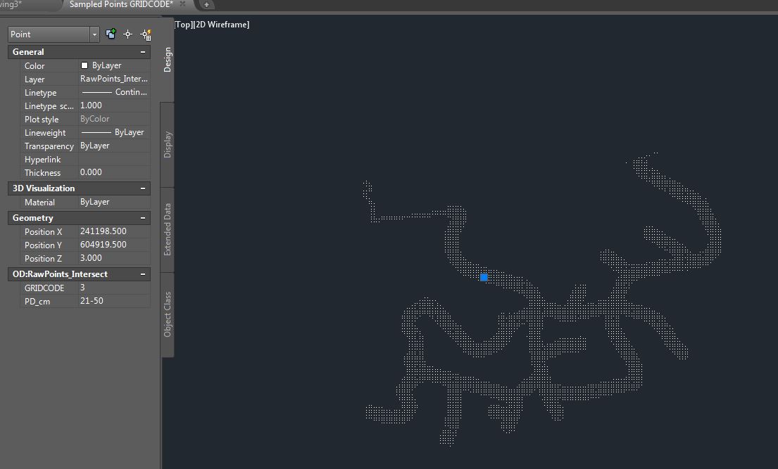
Thanks again for this - I resampled my points at 25m centres and have also done a Query > Alter Properties so that the GRIDCODE is the elevation as I was unsure how to do number 6 in your instructions - Add calculated field to transform PD_cm to the midlle value - can you explain this step please?


SamplePoints.jpg

neilyj (No connection with Autodesk other than using the products in the real world)
Did you find this post helpful? Feel free to Like this post.
Did your question get successfully answered? Then click on the ACCEPT SOLUTION button.

EESignature


AEC Collection 2025 UKIE (mainly Civil 3D UKIE and IW)
Win 11 Pro x64, 1Tb Primary SSD, 1Tb Secondary SSD
64Gb RAM Intel(R) Xeon(R) W-11855M CPU @ 3.2GHz
NVIDIA RTX A5000 16Gb, Dual 27" Monitor, Dell Inspiron 7760
Message 9 of 12
antoniovinci
in reply to: neilyj666

Here's my 2 cents, N.

Message 10 of 12
neilyj666
in reply to: antoniovinci

Thanks for the replies guys - the FDO Overlay Analysis was the crucial part of the equation....!!!


This is what I've come up with


2014-12-12 11_32_23-Autodesk AutoCAD Civil 3D 2015 - [Drawing7.dwg].jpg

neilyj (No connection with Autodesk other than using the products in the real world)
Did you find this post helpful? Feel free to Like this post.
Did your question get successfully answered? Then click on the ACCEPT SOLUTION button.

EESignature


AEC Collection 2025 UKIE (mainly Civil 3D UKIE and IW)
Win 11 Pro x64, 1Tb Primary SSD, 1Tb Secondary SSD
64Gb RAM Intel(R) Xeon(R) W-11855M CPU @ 3.2GHz
NVIDIA RTX A5000 16Gb, Dual 27" Monitor, Dell Inspiron 7760
Message 11 of 12
olivier.eckmann
in reply to: neilyj666

Hi,


for calculated field, it's something like that


( ToInt32(Substr(PD_cm, 0, Instr(PD_cm, '-') - 1)) + ToInt32(Substr(PD_cm, Instr(PD_cm, '-') + 1)) ) * 0.5


It's the median value between the interger before sign "-" and the integer after sign "-"


Just be careful with value which doesn't contains sign "-"  like 0 and 401+


Olivier

Message 12 of 12
Murph_Map
in reply to: neilyj666


@neilyj666 wrote:

Thanks for this Olivier - you make it sound easy but I'm lost at step 1....


I would do it the same way as Olivier. 

Murph
Supporting the troops daily.

Can't find what you're looking for? Ask the community or share your knowledge.

Post to forums  

Autodesk Design & Make Report