Globe link Add-in

Globe link Add-in

mairh_tsek
Collaborator Collaborator
16,121 Views
13 Replies
Message 1 of 14

Globe link Add-in

mairh_tsek
Collaborator
Collaborator

Hello all,


I use the Revit 2018.2. 

In my autodesk account I cannot find the 'Globe link' subscription add-in.

Is there something that I need to do?


Thank you in advance!

0 Likes
Accepted solutions (1)
16,122 Views
13 Replies
Replies (13)
Message 2 of 14

natasha.l
Alumni
Alumni

Hello @mairh_tsek


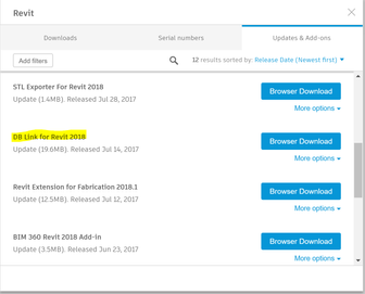
I am not sure about what product this is, I do see a DB Link add-in for Revit 2018. 


DBLink.PNG


I will move this post to the Revit forum for you, this is a product related issue and a product specialist could better assist you with these types of questions. 


Please "Accept Solution" if a reply or replies have helped resolve the issue or answered your question, to help others in the community.

0 Likes
Message 3 of 14

Viveka_CD
Alumni
Alumni

Hi @natasha.l


Thanks for helping out. Smiley Happy


Globe link is a subscription add-in that was available in older versions and not for RevitLT, but I'll have to confirm this with the product managers.


Thanks,


0 Likes
Message 4 of 14

Viveka_CD
Alumni
Alumni
Accepted solution

Hi @mairh_tsek


I just heard back from the team, and here's an update:

Currently the 'globe-link add in' is discontinued and not available in Revit 2018, last available in Revit 2014.


I see that on your other post, we've discussed the 'cad- to earth' and you seem to have issues with that. since that app is not an Autodesk product, I would suggest that you contact their support (amcbridge) Also see their help document.


If you can tell us more about your workflow and what you are trying to achieve we can discuss more about available export formats and workarounds.

For example: If you are looking to export an image from google maps we can save the image and use it as a background in Revit.


I look forward to hearing from you.


Regards,


0 Likes
Message 5 of 14

mairh_tsek
Collaborator
Collaborator

@Viveka_CD


Thank you for your answer.


I want to place my model in a 3d google environment. I want to be able to see the others building in 3d too. 

Check the image.


Using the Cesium in CADtoEarth I take a 2D google environment.


Is it possible with the Revit 2018?


Thank you in advance!

0 Likes
Message 6 of 14

Viveka_CD
Alumni
Alumni

Hi @mairh_tsek


Thank you for your response and what you have tried so far.

I got your messages.


Let me get back to you. I've opened this topic to the team for workarounds and further feedback.


Regards,

0 Likes
Message 7 of 14

Viveka_CD
Alumni
Alumni

Hi @mairh_tsek


The best workaround would be to use the background image and trace/model in Revit - this gives you the option of making it parametric.


Regards,


0 Likes
Message 8 of 14

Anonymous
Not applicable

We export the shell of the Revit model to SketchUp Pro....

Message 9 of 14

benhagerman
Enthusiast
Enthusiast

I think the new Autodesk Infrawoks is supposed to do this. I haven't had the chance to try it out for myself, but if it is as advertised, this is exactly what it is supposed to do. I believe you do need a 3rd party mapping software to acquire the surface, but all together should do the trick. I look forward to hearing if anyone has had the opportunity to try it out with a Revit model.

0 Likes
Message 10 of 14

kayau
Explorer
Explorer

Hi @mairh_tsek

You can try a workflow using Navisworks. 

  1. Setting accurate coordinates in Revit (I use Civil 3D model site and acquire coordinates in Revit)
  2. Exporting model to Navisworks as NWC
  3. After opening your model in Navisworks there is Google Earth KML export option at Output menu.
  4. At pop up menu you have to choose three different points (corners) of your model and assign Longtitude and Latitude values to each points. 3 points are important. Converting coordinate system is a bit precise work. I took help at converting coordinates from a colleague, who is Survey Engineer.

Regards,


Ugur Kaya

Message 11 of 14

mairh_tsek
Collaborator
Collaborator

@kayau


Thank you for your answer!

This is what I a trying to do the last days but when I fill the values in the pop up menu the model displays in a completely wrong position.

Check the thread below:

https://forums.autodesk.com/t5/navisworks-forum/navisworks-kml-options/m-p/8441605#M18734 


If you have a guideline it will be appreciated!

0 Likes
Message 12 of 14

kayau
Explorer
Explorer

Hello @mairh_tsek,

In my case, which is located in Turkey, I tried to convert my coordinate system to "GRS 80" system. At the next step, I change degree, minutes, seconds to longtitude and latitude. As I saw at your post, you are converting to "WGS84". Hope this converting method will help you.

0 Likes
Message 13 of 14

cadwomen
Collaborator
Collaborator

und auch in Revit 2020 nicht und auch nicht wirklich ein gangbare Weg.


Also WIE IMMER mit Autodesk

Es gibt was tolles Neues

UPS es wird schwierig

nun ja wir schaun mal

und ne das ist nix braucht niemand .. Hauptsache Show


cu cw

If my post answers your question, please mark it as an Accepted Solution, so that others can find answers quickly!
0 Likes
Message 14 of 14

GoldenGateNetwork
Advocate
Advocate

Good afternoon, any updates please? so it's completely impossible to publish my model into Google Earth?

I am working on my NCARB towards my California Architect License,
if you think you can help me to complete my AXP, please let me know, I will really appreciate it. Thank you & Stay Wealthy, Happy, Healthy and Safe 🙂 
Pedro Nel Ospina Hincapié
Bachelor in Architecture - Naval Architecture Student
0 Likes