Community
Civil 3D Forum
Welcome to Autodesk’s Civil 3D Forums. Share your knowledge, ask questions, and explore popular AutoCAD Civil 3D topics.
Turn on suggestions
Auto-suggest helps you quickly narrow down your search results by suggesting possible matches as you type.
Reply
Topic Options
- Subscribe to RSS Feed
- Mark Topic as New
- Mark Topic as Read
- Float this Topic for Current User
- Bookmark
- Subscribe
- Printer Friendly Page
Message 1 of 4
08-12-2015
01:58 PM
- Mark as New
- Bookmark
- Subscribe
- Mute
- Subscribe to RSS Feed
- Permalink
- Report
08-12-2015
01:58 PM
SURFACE LABEL (volume surface) STYLE HELP
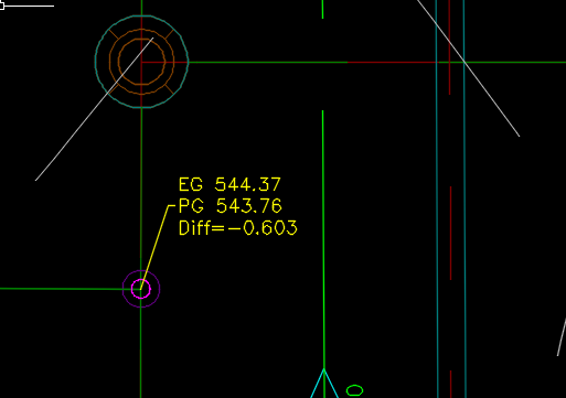
I am needing to place a label on a surface that has the elevation of the base elevation at a location, the comparison elevation at a location, and the differnece in elevation between the two.
I am tryng to find a way to do this without having to manually put in the numbers (introducing human error).
Thanks.
3 REPLIES 3
Message 2 of 4
08-12-2015
03:20 PM
- Mark as New
- Bookmark
- Subscribe
- Mute
- Subscribe to RSS Feed
- Permalink
- Report
08-12-2015
03:20 PM
I'm sure there are several ways to do this. One is created a typical spot elevation label. Create a Reference Text component within the Label Style Composer. Then created a Third component that also references a surface (for your volume surface elevation). You will need a volume elevation surface style that display either the border or elevation within the Surface Style-Display tab. Once you have all this set you are ready to add your label. Make sure that your existing surface, proposed surface, and elevation volume surface are displayed. Then all you have to do is select the surfaces in sequence. Once you are doing with the labeling you can turn off the volume surface display.
Tony Carcamo
President/Owner
Civil CAD Learning Solutions
DFW BIM Infrastructure User Group
LinkedIn | Twitter | Instagram | DFWBIUG |User Group
![]()
Message 3 of 4
08-12-2015
03:27 PM
- Mark as New
- Bookmark
- Subscribe
- Mute
- Subscribe to RSS Feed
- Permalink
- Report
08-12-2015
03:27 PM
Or you can use the new Earthwork Plan production feature in the new Civil 3D Productivity Pack 1 for 2016. Great simple tool. Once you install the productivity pack the feature is looked in the Toolbox

Tony Carcamo
President/Owner
Civil CAD Learning Solutions
DFW BIM Infrastructure User Group
LinkedIn | Twitter | Instagram | DFWBIUG |User Group
![]()
Message 4 of 4
08-13-2015
10:44 AM
- Mark as New
- Bookmark
- Subscribe
- Mute
- Subscribe to RSS Feed
- Permalink
- Report
Reply
Topic Options
- Subscribe to RSS Feed
- Mark Topic as New
- Mark Topic as Read
- Float this Topic for Current User
- Bookmark
- Subscribe
- Printer Friendly Page
Forums Links
Can't find what you're looking for? Ask the community or share your knowledge.
Post to forums

