Community
Civil 3D Forum
Welcome to Autodesk’s Civil 3D Forums. Share your knowledge, ask questions, and explore popular AutoCAD Civil 3D topics.
Turn on suggestions
Auto-suggest helps you quickly narrow down your search results by suggesting possible matches as you type.
Reply
Topic Options
- Subscribe to RSS Feed
- Mark Topic as New
- Mark Topic as Read
- Float this Topic for Current User
- Bookmark
- Subscribe
- Printer Friendly Page
Message 1 of 8
08-30-2017
11:12 AM
- Mark as New
- Bookmark
- Subscribe
- Mute
- Subscribe to RSS Feed
- Permalink
- Report
08-30-2017
11:12 AM
General Segment Label
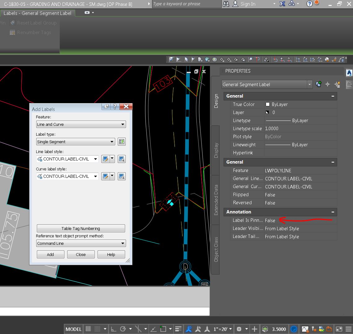
I'm using General Segment Labels to label the elevations of contour polylines. The frustrating part of these labels is that they will move along the polyline if the polyline is stretched, trimmed, or extended. Is there a way to pin the label? The label properties show a place for pinning, but I can't find a way to toggle this function (see attached screenshot). Thanks!
~Steve
7 REPLIES 7
Message 2 of 8
08-30-2017
11:23 AM
- Mark as New
- Bookmark
- Subscribe
- Mute
- Subscribe to RSS Feed
- Permalink
- Report
08-30-2017
11:23 AM
If your contour lines have elevation. Just use the contour labels. They should work in single mode. I've presonal never had much luck with pinning.
Rick Jackson
Survey CAD Technician VI
Did you find this post helpful? Feel free to Like this post.
Did your question get successfully answered? Then click on the ACCEPT SOLUTION button.
Message 3 of 8
08-30-2017
11:26 AM
- Mark as New
- Bookmark
- Subscribe
- Mute
- Subscribe to RSS Feed
- Permalink
- Report
08-30-2017
11:26 AM
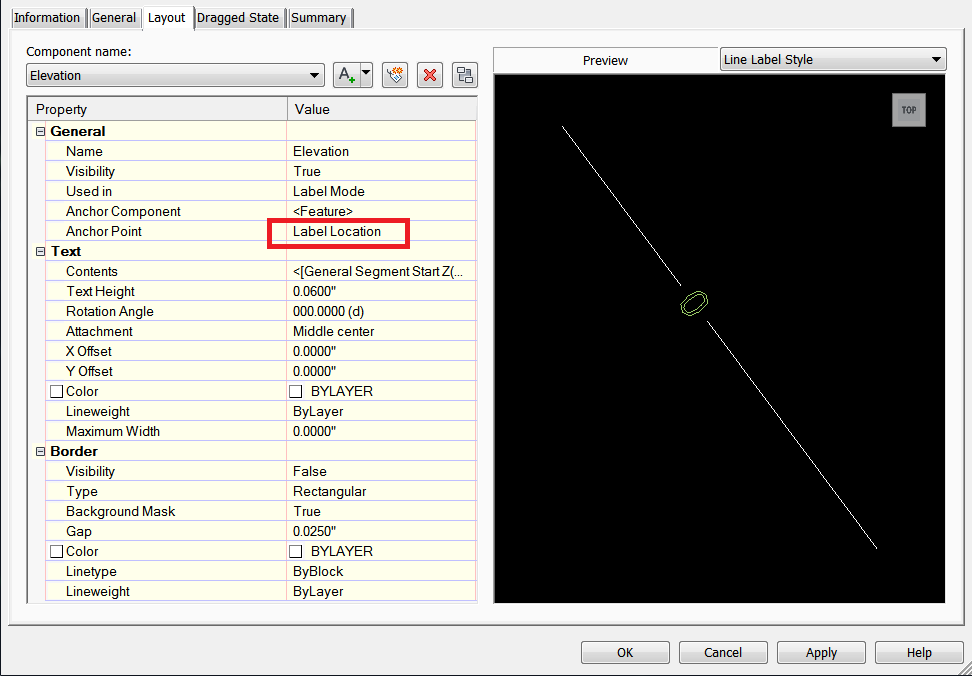
Set the anchor point to Label Location. Make sure you are changing it on the proper component and not the Table Tag

Message 4 of 8
08-30-2017
11:52 AM
- Mark as New
- Bookmark
- Subscribe
- Mute
- Subscribe to RSS Feed
- Permalink
- Report
08-30-2017
11:52 AM
I think its just the nature of the general segment label beast.
The label is tagged to a certain segment number of the polyline when it is placed. If you add segments to the end of the line/curve all if fine. If you add to the beginning, they shift to get back to the same segment number they were on.
If it is anchored to the middle it will move to the middle as the line/curve gets longer or shorter. If it is anchored to 'label location' it will move proportionately.
Message 5 of 8
08-30-2017
11:55 AM
- Mark as New
- Bookmark
- Subscribe
- Mute
- Subscribe to RSS Feed
- Permalink
- Report
08-30-2017
11:55 AM
That's a pretty good explanation. I wonder if there is a better way to label the elevation of a polyline...
Message 6 of 8
08-30-2017
12:00 PM
- Mark as New
- Bookmark
- Subscribe
- Mute
- Subscribe to RSS Feed
- Permalink
- Report
08-30-2017
12:00 PM
Use a surface label. It will lable the pline just as it would a true c3d surface. That's where I was getting at in my prior post
Rick Jackson
Survey CAD Technician VI
Did you find this post helpful? Feel free to Like this post.
Did your question get successfully answered? Then click on the ACCEPT SOLUTION button.
Message 7 of 8
08-30-2017
12:04 PM
- Mark as New
- Bookmark
- Subscribe
- Mute
- Subscribe to RSS Feed
- Permalink
- Report
08-30-2017
12:04 PM
I must be missing something. When I try that it asks that I "Select a surface" first. I can't select the polyline using that command.
Message 8 of 8
08-30-2017
08:23 PM
- Mark as New
- Bookmark
- Subscribe
- Mute
- Subscribe to RSS Feed
- Permalink
- Report
08-30-2017
08:23 PM
Use an object field.
May I ask why you don't turn you poly lines with elevation into a surface?
May I ask why you don't turn you poly lines with elevation into a surface?
Joe Bouza
Did you find this post helpful? Feel free to Like this post.
Did your question get successfully answered? Then click on the ACCEPT SOLUTION button.
Reply
Topic Options
- Subscribe to RSS Feed
- Mark Topic as New
- Mark Topic as Read
- Float this Topic for Current User
- Bookmark
- Subscribe
- Printer Friendly Page
Forums Links
Can't find what you're looking for? Ask the community or share your knowledge.
Post to forums

