Community
- Forums Home
- >
- Civil 3D Community
- >
- Civil 3D Forum
- >
- create contours from comparing multiple surfaces
Civil 3D Forum
Welcome to Autodesk’s Civil 3D Forums. Share your knowledge, ask questions, and explore popular AutoCAD Civil 3D topics.
Turn on suggestions
Auto-suggest helps you quickly narrow down your search results by suggesting possible matches as you type.
Reply
Topic Options
- Subscribe to RSS Feed
- Mark Topic as New
- Mark Topic as Read
- Float this Topic for Current User
- Bookmark
- Subscribe
- Printer Friendly Page
Message 1 of 9
01-23-2014
08:09 PM
- Mark as New
- Bookmark
- Subscribe
- Mute
- Subscribe to RSS Feed
- Permalink
- Report
01-23-2014
08:09 PM
I have a project that I created three surfaces. Existing, over excavation, & finish grade. Client wants to see contours of max cut. The issue is the overex and FG overlap each other vertically. If I paste FG on top of overex, I lose cut areas where overex is deeper and vice versa. I'm at a loss on how to do this.
Thanks
Mike Porter
https://provostandpritchard.com/
https://provostandpritchard.com/
Solved! Go to Solution.
Solved by CADmgrMike. Go to Solution.
8 REPLIES 8
Message 2 of 9
01-23-2014
08:18 PM
- Mark as New
- Bookmark
- Subscribe
- Mute
- Subscribe to RSS Feed
- Permalink
- Report
01-23-2014
08:18 PM
Have you tried to create a volume surface using the FG and overex surfaces, and use it to get your cut/fill contours?
BTW, how does over-excavation end up above final grade?
Hans Moller
Surveying & Management Services
Gladstone Australia
Metabox 16GB, Intel i7-9700K 3.6Ghz, 500GB SSD, 2TB HDD Nvidia GTX 1060
AutoCAD Civil 3D 2018
Surveying & Management Services
Gladstone Australia
Metabox 16GB, Intel i7-9700K 3.6Ghz, 500GB SSD, 2TB HDD Nvidia GTX 1060
AutoCAD Civil 3D 2018
Message 3 of 9
01-23-2014
08:45 PM
- Mark as New
- Bookmark
- Subscribe
- Mute
- Subscribe to RSS Feed
- Permalink
- Report
01-23-2014
08:45 PM
Let me clarify. I used the word overex but technically it's remediation cut of existing ground not driven by final design.
So there are places where final grading will fill over the overex and places where it will cut deeper than the overex.
1. If I paste the final on top of the overex, I lose the deeper cut areas of the overex.
2. If I paste the overex on top of the final, I lose the deeper cut areas of the final.
does that make sense?
Mike Porter
https://provostandpritchard.com/
https://provostandpritchard.com/
Message 4 of 9
01-23-2014
09:19 PM
- Mark as New
- Bookmark
- Subscribe
- Mute
- Subscribe to RSS Feed
- Permalink
- Report
01-23-2014
09:19 PM
Yes, understood. Basically the same as what I call a strip surface, or start surface, bad soil removed etc.
Back then to my first question: Have you created a volume surface? Another word for it is a difference TIN. The contours you create from this will show elevation differences, catering for cut or fill. You can also create a grid of points over this TIN and the points will show cut or fill elevations. No pasting of one surface on to another, this is a separate new surface.
Hans Moller
Surveying & Management Services
Gladstone Australia
Metabox 16GB, Intel i7-9700K 3.6Ghz, 500GB SSD, 2TB HDD Nvidia GTX 1060
AutoCAD Civil 3D 2018
Surveying & Management Services
Gladstone Australia
Metabox 16GB, Intel i7-9700K 3.6Ghz, 500GB SSD, 2TB HDD Nvidia GTX 1060
AutoCAD Civil 3D 2018
Message 5 of 9
01-23-2014
09:34 PM
- Mark as New
- Bookmark
- Subscribe
- Mute
- Subscribe to RSS Feed
- Permalink
- Report
01-23-2014
09:34 PM
Yes I have created two volume surfaces.
I forgot to throw in the other kink. There are places where the final grade cuts through existing and no overex at all.
So I created a volume surf of exist to overex and did cut fill ticks.
I also created a volume surf of exist to final and did cut fill ticks.
that gave me a visual of the deepest cut in all locations.
I still can't figure out how to get a surface and make contours of the deepest cut.
Mike Porter
https://provostandpritchard.com/
https://provostandpritchard.com/
Message 6 of 9
01-24-2014
05:06 AM
- Mark as New
- Bookmark
- Subscribe
- Mute
- Subscribe to RSS Feed
- Permalink
- Report
01-24-2014
05:06 AM
I can't quite visualise what you are trying to do or achieve - can you post a sketch section or something?
AEC Collection 2025 UKIE (mainly Civil 3D UKIE and IW)
Win 11 Pro x64, 1Tb Primary SSD, 1Tb Secondary SSD
64Gb RAM Intel(R) Xeon(R) W-11855M CPU @ 3.2GHz
NVIDIA RTX A5000 16Gb, Dual 27" Monitor, Dell Inspiron 7760
neilyj (No connection with Autodesk other than using the products in the real world)
Did you find this post helpful? Feel free to Like this post.
Did your question get successfully answered? Then click on the ACCEPT SOLUTION button.
AEC Collection 2025 UKIE (mainly Civil 3D UKIE and IW)
Win 11 Pro x64, 1Tb Primary SSD, 1Tb Secondary SSD
64Gb RAM Intel(R) Xeon(R) W-11855M CPU @ 3.2GHz
NVIDIA RTX A5000 16Gb, Dual 27" Monitor, Dell Inspiron 7760
Message 7 of 9
01-24-2014
07:49 AM
- Mark as New
- Bookmark
- Subscribe
- Mute
- Subscribe to RSS Feed
- Permalink
- Report
01-24-2014
07:49 AM
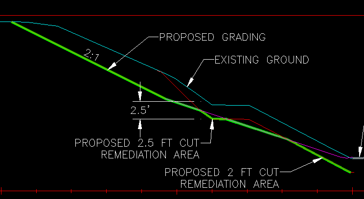
I wasnt' where I could post visuals last night, so now I'll post some screen shots that might help explain what I'm being asked to do.
Scenario 1 - FG is lower than overex so I need that cut number
Scenario 2 - Overex is lower than FG so I need that cut number
Contours - Another scenario where in some places overex is lower and in others the FG is lower.
The green line is what they want to see as a contour surface with contour labeling.
I figured out how to do cut/fill ticks and get what they want to see. I made two sets of cut/fill ticks in the exact same location.
1. Compare exist to overex
2. compare exist to FG
Delete the smallest cut number at each grid point. Tedious but were talking around 200 points.
I think I figured out how to make the contour surface I need.
Create two cogo points at all the cut tick grid points.
One from the overex surface and one from the FG surface.
Delete the highest elevation point at each grid point.
Make surface from all the lowest elevation points.
We'll see how it goes this morning. 🙂
Mike Porter
https://provostandpritchard.com/
https://provostandpritchard.com/
Message 8 of 9
01-24-2014
07:58 AM
- Mark as New
- Bookmark
- Subscribe
- Mute
- Subscribe to RSS Feed
- Permalink
- Report
01-24-2014
07:58 AM
I think I'd build up a hybrid surface by extracting the minimum distance between surfaces as a polyline and using it as an outer boundary on copy of a surface to create a partial surface. Do this as many times as required (probably only twice) and then paste these partial surfaces together.
neilyj (No connection with Autodesk other than using the products in the real world)
Did you find this post helpful? Feel free to Like this post.
Did your question get successfully answered? Then click on the ACCEPT SOLUTION button.
AEC Collection 2025 UKIE (mainly Civil 3D UKIE and IW)
Win 11 Pro x64, 1Tb Primary SSD, 1Tb Secondary SSD
64Gb RAM Intel(R) Xeon(R) W-11855M CPU @ 3.2GHz
NVIDIA RTX A5000 16Gb, Dual 27" Monitor, Dell Inspiron 7760
Message 9 of 9
01-24-2014
04:52 PM
- Mark as New
- Bookmark
- Subscribe
- Mute
- Subscribe to RSS Feed
- Permalink
- Report
01-24-2014
04:52 PM
When you say extracting minimum distances from surfaces, are you talking about the 0.0 contour line when you compare two surfaces?
Or is there another method?
That was my original idea, but the existing surface data is is on an undulating hillside, so the intersection of the overex and the FG was so erratic and complex that I had 0.0 contour lines all over the place.
I ended up doing it like my post above. Took me about 2 hours to create points from two surfaces on a 5x5 grid (about 1200) and then weed out the highest 600 points. Created a Rough Cut surface from those 600 points and then I could make contours (which is what they wanted to see).
The dirt qty from comparing my Rough Cut surface to exist was only about 70CY different than what I got from comparing exist to overex, overex to FG and then adding those two numbers together.
thanks all for the input.
Mike Porter
https://provostandpritchard.com/
https://provostandpritchard.com/
Reply
Topic Options
- Subscribe to RSS Feed
- Mark Topic as New
- Mark Topic as Read
- Float this Topic for Current User
- Bookmark
- Subscribe
- Printer Friendly Page
Forums Links
Can't find what you're looking for? Ask the community or share your knowledge.
Post to forums

