Exporting Image from EPSG 3857 (Auxiliary or Pseudo Mercator)to UTM Z17

Exporting Image from EPSG 3857 (Auxiliary or Pseudo Mercator)to UTM Z17

Baz_man
Enthusiast Enthusiast
7,988 Views
17 Replies
Message 1 of 18

Exporting Image from EPSG 3857 (Auxiliary or Pseudo Mercator)to UTM Z17

Baz_man
Enthusiast
Enthusiast

I have brought an image captured from a web map application that I have placed in its original projection.

I need to export it to NAD83 Z17 and have tried the options available in Raster Design but with no luck (the message is invalid projection or something to that extent).

Is this possible in Raster Design or have I missed something in the export process?

We use these types of images from web map sites but don't want to have to connect to them in Map, save them back to a drawing (after assigning it EPSG 3857 since it is not automatically recognized) and then attach/query to the proper zone.

It seems odd that Map can re-project them but Raster Design can't.


0 Likes
Accepted solutions (2)
7,989 Views
17 Replies
Replies (17)
Message 2 of 18

Pointdump
Consultant
Consultant

Hi Barry,
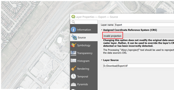
A couple of problems with your tiff. It's not geo-referenced, unless it really is supposed to be on "Null Island", West of Africa. Second is that it lacks band data, so it appears washed out.
I drag-n-dropped it into QGIS just to check for geo-referencing, and here's what I got.
Dave


ExportTiff_1.png


Dave Stoll
Las Vegas, Nevada

EESignature

64GB DDR4 2400MHz ECC SoDIMM / 1TB SSD
NVIDIA Quadro P5000 16GB
Windows 10 Pro 64 / Civil 3D 2027
0 Likes
Message 3 of 18

Baz_man
Enthusiast
Enthusiast

Thanks for your reply Dave.

Originally I tried to upload the .tfw file that had the spatial reference info and the uploader rejected it. I just now tried to rename the extension and the uploaded recognized it wasn't the proper file type.

Here is a link to the website, but it is only one we use. 

In this case I had an area near Toronto on the map (scroll in) and used the 'Markup and Printing' tab - 'Export' to capture and image. It gives the EPSG 3857 by default.

I then tried to load it into a NAD83 UTM Zone 17 .dwg using Raster Design. The coordinates were way off as it did not re-project.

I tried exporting (several times with different parameters / extensions) the inserted image back to UTM Z17 and then re-insert but it did not change the coordinates.

Any suggestions as to what I can try?

Did I miss somethign

0 Likes
Message 4 of 18

Pointdump
Consultant
Consultant

Barry,
Autodesk Forums will accept any file format if you zip it first. Or you can include the 6-line TFW file as text in the body of your message.
I don't see a link to your data in either of your posts.

Dave

Dave Stoll
Las Vegas, Nevada

EESignature

64GB DDR4 2400MHz ECC SoDIMM / 1TB SSD
NVIDIA Quadro P5000 16GB
Windows 10 Pro 64 / Civil 3D 2027
0 Likes
Message 5 of 18

Baz_man
Enthusiast
Enthusiast

My apologies. I hit 'post' before pasting the link.


I have attached the .zip file.


Here is the link in case you'd like to have a look for yourself:

https://www.lioapplications.lrc.gov.on.ca/MakeATopographicMap/index.html?viewer=Make_A_Topographic_M...


Cheers,

Barry

0 Likes
Message 6 of 18

Pointdump
Consultant
Consultant

Barry,

Thanks for posting the link.
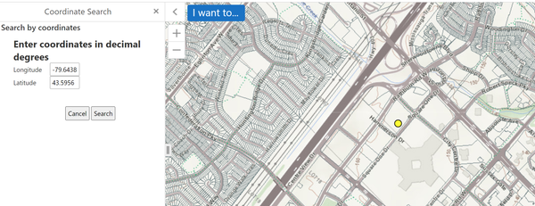
How do you download a Tiff from the site? I can find the right area, but the imagery is not arranged in tiles.
Dave


TotontoArea_1.png


Dave Stoll
Las Vegas, Nevada

EESignature

64GB DDR4 2400MHz ECC SoDIMM / 1TB SSD
NVIDIA Quadro P5000 16GB
Windows 10 Pro 64 / Civil 3D 2027
0 Likes
Message 7 of 18

Pointdump
Consultant
Consultant

Barry,
OK, I found the 'Markup and Printing' tab and exported something similar to what you have. (I didn't use it. I used yours.)
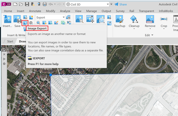
I used Raster Design to import your image into Civil 3D, in a drawing assigned UTM83-17. Then I used IEXPORT to export a GeoTiff in UTM83-17.
So let's figure out where the wheels fell off for you.
Dave


TotontoArea_2.png


Dave Stoll
Las Vegas, Nevada

EESignature

64GB DDR4 2400MHz ECC SoDIMM / 1TB SSD
NVIDIA Quadro P5000 16GB
Windows 10 Pro 64 / Civil 3D 2027
0 Likes
Message 8 of 18

Baz_man
Enthusiast
Enthusiast

The attached shows what I get with the coordinates circled after I import the image (either from the map site or having transformed it after placing it in its native projection in a .dwg). It's like the coordinates did not get transformed through the export or when using MAPIINSERT.

0 Likes
Message 9 of 18

Baz_man
Enthusiast
Enthusiast

I have downloaded your image and it came to the correct position.

I am certain I tried all manner of exports with resulting no re-projection once inserted into the Nad83-17 .dwg. 

What parameters did you use?

0 Likes
Message 10 of 18

Pointdump
Consultant
Consultant
Accepted solution

Barry,
MAPIINSERT sometimes won't transform an image. Use IINSERT in the Raster Tools instead.
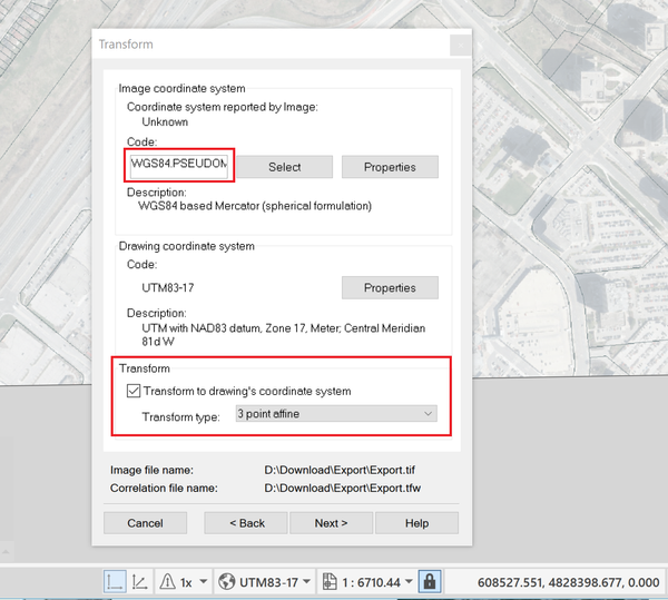
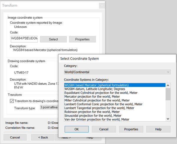
I started off with a new Metric drawing assigned UTM83-17. When I used Raster Tools IINSERT, under "Insert Options" I used "Insertion Wizard". On the Transform page I identified the image as being WGS84.PseudoMercator and checked "Transform to drawing's coordinate system". I usually use the 3 Point Affine Transform Type.
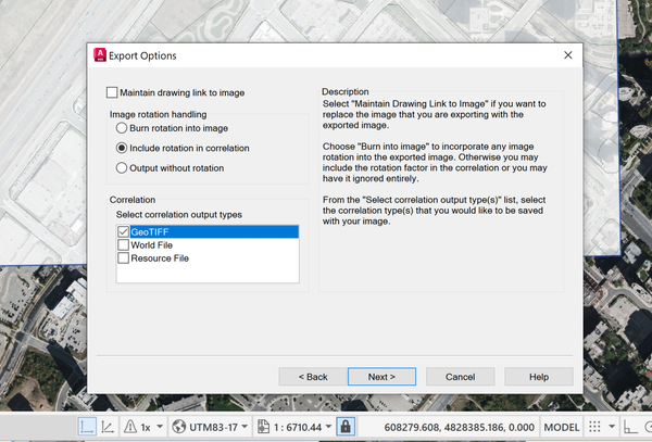
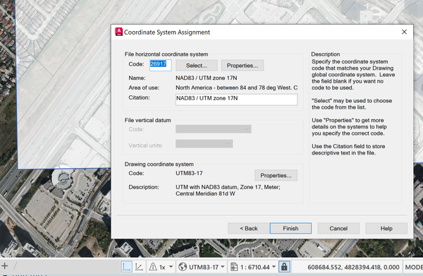
When using IEXPORT I just go with the defaults until the Export Options Page. Click GeoTIFF. That way you don't need a TFW file to tag along with the image. Last page is the Coordinate System Assignment.
Dave


RasterTools_1.png


RasterTools_2.png


RasterTools_3.png


Dave Stoll
Las Vegas, Nevada

EESignature

64GB DDR4 2400MHz ECC SoDIMM / 1TB SSD
NVIDIA Quadro P5000 16GB
Windows 10 Pro 64 / Civil 3D 2027
0 Likes
Message 11 of 18

Baz_man
Enthusiast
Enthusiast

Thanks again.

It sounds like IINSERT should be my go to instead of MAPIINSERT.


However, there is still some problem that I can't identify.


When I go through the wizard it gets to the TRANSFORM pane fine. Notice it recognizes the Pseudo.Mercator projection. If I look for it in the 'Select' area it is not found in the list. If I transform to drawing coordinates I get an error message: 'The coordinate system chosen for this image is invalid'.

What am I missing here?

0 Likes
Message 12 of 18

Pointdump
Consultant
Consultant
Accepted solution

Barry,
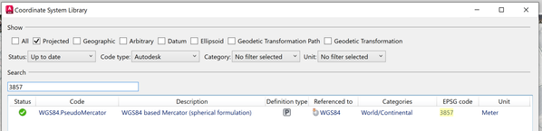
That dialogue box is telling you the coordinates of your image exceed the "-180 to +180" of the Geographic Coordinate System "LL". You'll need to hit the Select Button. The one you're looking for is in Catagory "World/Continental" and is called "WGS84.PseudoMercator". If you first do a search for 3857 in MAPCSLIBRARY it will arm you with enough information to find it. Autodesk sure doesn't make it easy.
Dave


RasterTools_4.png


RasterTools_5.png


Dave Stoll
Las Vegas, Nevada

EESignature

64GB DDR4 2400MHz ECC SoDIMM / 1TB SSD
NVIDIA Quadro P5000 16GB
Windows 10 Pro 64 / Civil 3D 2027
0 Likes
Message 13 of 18

Baz_man
Enthusiast
Enthusiast

That did it.

I saw some WGS84 projections in the default list and ignored the drop down.

Thanks you for all of your help - muchly appreciated.

We can now put them in a more automated fashion and eliminate using the ALIGN command.


Message 14 of 18

sunf1
Observer
Observer

Hey! It sounds like you're dealing with a tricky projection challenge in Raster Design. Have you considered checking the coordinate system settings and ensuring a smooth game plan for exporting from EPSG 3857 to NAD83 Z17?


0 Likes
Message 15 of 18

Baz_man
Enthusiast
Enthusiast

Hi Sunf1,

There is already a method marked as solution in this inquiry.

0 Likes
Message 16 of 18

bottleneckc
Explorer
Explorer

It seems like the issue might be with how Raster Design handles projections. EPSG 3857 (Auxiliary or Pseudo Mercator) is a web-specific projection, and Raster Design might be having trouble handling the transformation correctly. You could try re-projecting the image using a different tool before bringing it into Raster Design, or use a coordinate system transformation within Map to convert it properly into NAD83 Z17. If you're still having issues, consider using a more manual approach to set the correct spatial reference before exporting. It should work, just make sure the source and destination projections are correctly matched. Let me know how it goes!

0 Likes
Message 17 of 18

Baz_man
Enthusiast
Enthusiast

You should scroll up see one of the solutions in this thread. There is no need to go outside of Raster Design or do it manually, as you suggested.

0 Likes
Message 18 of 18

Baz_man
Enthusiast
Enthusiast

Once again, I will advise you to scroll up to see the accepted solutions.