In more detail, I have surveyed multiple points of what is essentailly a feild. I have the points displayed correctly in a visually 2d format using plan view. Each point has xyz values that i would like displayed at a small offset to each point.
I can do it point by point, using ID and copying the values from the command line but this is hugly time consuming as you can imagine.
PLEASE HELP....
Kind regards,
Ben.
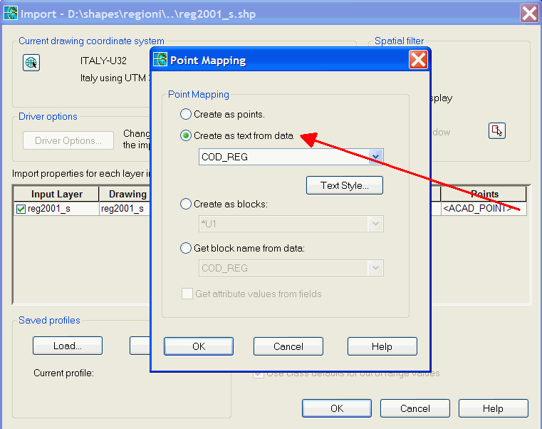
You could _MAPEXPORT to shapefile, then _MAPIMPORT back, labelling automatically in the following way:
one option
mapexport your points to a shp or sdf file with property x1,y1,z1selected in attributes
put the shp or sdf into your map and style the labels.
change the .txt extension to .layer and d&d into a empty map
another option is annotation
all this is explained in help.
dave
Thanks so much for the reply!
One snag though... My version of autocad doesn't seem to have the mapexport command?
I'm using autocad 2015 LT....
In the command bar I typed both mapexport and _mapexport with no luck. Any ideas?
It might be worth noting that I checked in the CUI to see if mapexport/import was hiding away some place but no luck there either.
Really starting to pull my hair out now ha.
To make it easier to follow what I'm trying to do I've attached a couple of screen grabs.
This is my survey. Its a pile matt level survey (or it will be once I can display the values of the points).
I would like to find a quick and easy way to process the points so that I have a drawing displaying information as per the image below...
As said before, the above was created by simply ID'ing the points in turn and then copying the command bar info and then pasting as text... Not great when I have 1000's of points ha!
Any takers?
@Anonymous wrote:
One snag though... My version of autocad doesn't seem to have the mapexport command?
I'm using autocad 2015 LT....
The mapexport is an AutoCAD MAP3D command, even full version Autocad does not have that command let along LT.. If you will be doing this type of work you will need to move up to Map3D or even Civil3D.
How are you inserting the points from the survey?
You can create a block with an attribute and use a field with the block insertion point as the attributte if you can insert the points into AutoCAD LT as blocks.
Can't find what you're looking for? Ask the community or share your knowledge.