- Forums Home
- >
- Revit Products Community
- >
- Revit Architecture Forum
- >
- Creating toposurface from dwg import
- Subscribe to RSS Feed
- Mark Topic as New
- Mark Topic as Read
- Float this Topic for Current User
- Bookmark
- Subscribe
- Printer Friendly Page
- Mark as New
- Bookmark
- Subscribe
- Mute
- Subscribe to RSS Feed
- Permalink
- Report
I have having such frustrations trying to import our land survyors 3D Autocad drawing Revit and create a new toposurface.
I have followed all the steps in the tutorials and it's right at the last step where you click on (green tick) that I have my problems. It says that 'The surface must have at least three distinct Points" I have checked the Autocad drawing and the countours are drawn with the X and Y coordiates as well as elevation heights. I just dont know the last piece of the puzzle to make this work!?! Does anyone have any guidance for me? Have spent too many hours trying to figure this out.
Solved! Go to Solution.
Solved by gregamhale. Go to Solution.
- Mark as New
- Bookmark
- Subscribe
- Mute
- Subscribe to RSS Feed
- Permalink
- Report
Just verifying your workflow;
You imported/linked the CAD topo file into Revit. (Make sure that the "Current View Only" box is unchecked)
You went to the Massing & Site tab and selected the "Toposurface" tool
You selected the "Crete from Import" tool and selected the CAD file
Yoiu selected the appropriate Topo Layers by which to creat the toposurface from
You the finalize by selecting the Finish Editing tool (green check mark)
Then zoom extents/zoom all and you should see the topo.
- Mark as New
- Bookmark
- Subscribe
- Mute
- Subscribe to RSS Feed
- Permalink
- Report
Yes, Those are the steps I've followed, to the letter.
When I click on the CAD file it gives me a warning message:
'A boundary on this surface could not be autodetected. Revit will impose one, but it may be larger than you want.'
Then when I click the green tick it gives me a error message:
'The surface must have at least three distinct Points.'
I presume there is an error with the AutoCAD file but when I've checked the file all the contour lines have heights etc. I have no idea what else the issue may be. Pretty stuck at this point.
- Mark as New
- Bookmark
- Subscribe
- Mute
- Subscribe to RSS Feed
- Permalink
- Report
If you post the CAD file, I'll give it a run to see if there's something wrong with it.
- Mark as New
- Bookmark
- Subscribe
- Mute
- Subscribe to RSS Feed
- Permalink
- Report
That would be fantastic, thank you.
This is a file that I cleaned up. The other drawing had heaps of other info on it.
- Mark as New
- Bookmark
- Subscribe
- Mute
- Subscribe to RSS Feed
- Permalink
- Report
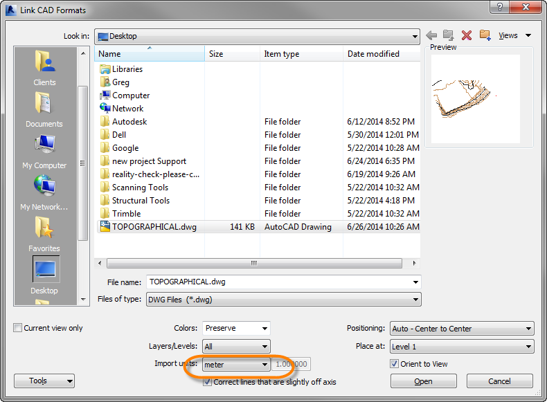
I believe your issue is that you need to insert the CAD Topo fiole using Meters as the unit. When you insert the file with "Auto-Detect" for the import units, you get a very small topo. Below is a screenshot and attached is a file with the correct Revit topo (Revit 2014).
Also, as a matter of practice, I typically recommend creating a topo in a separate file called "Site." These can get fairly big and start bogging down the file. You can also go so far as to set up the site on the correct coordinate system so that your building elevations report correctly. Then you can link the building file into the site file and share coordinates. It's not necessary, but can be helpful on many projects.
I hope this resolves your issue.
Cheers
- Mark as New
- Bookmark
- Subscribe
- Mute
- Subscribe to RSS Feed
- Permalink
- Report
- Mark as New
- Bookmark
- Subscribe
- Mute
- Subscribe to RSS Feed
- Permalink
- Report
Hi gregamhale,
I follow your steps, but still does not work for my CAD file.
Greatly appreciate your help,
Attched is CAD file for easy ref.
FYI, Previously this dwg is unitless and i changed to Meter.
Thanks!
- Mark as New
- Bookmark
- Subscribe
- Mute
- Subscribe to RSS Feed
- Permalink
- Report
Hello,
please, I have a problem with creating toposurface from import dwg file and txt file too. I tried it like in these tutorials:
https://www.youtube.com/watch?v=LA7JXt-152s&ab_channel=CADStudio and https://www.youtube.com/watch?v=er8XRhCgLE8&ab_channel=Jerryn.
I have a original txt file and I prepared it like in second tutorial and I put it into the revit. But it didn´t work. The warning message is: Imported Toposurface Points are licated a large distance from the model and might not display properly. Points will be centered on the model instead.
The first video, I tried it and it didnt´t work too. The warning message is: Imported Toposurface points are located a large distance from the model and might display properly. Points will be centered on the model instead.
Can you help me please ? I send you my files and can you try it please? I have revit 2018.
- Mark as New
- Bookmark
- Subscribe
- Mute
- Subscribe to RSS Feed
- Permalink
- Report
Large coordinate systems like S-JTSK can cause some issues. You can use Civil 3D and our toposurface-transfer tool in Revit Tools - this will solve it. See https://www.youtube.com/watch?v=SWbLGSVas58 (in Czech)
Vladimir Michl, www.cadstudio.cz - www.cadforum.cz

- Subscribe to RSS Feed
- Mark Topic as New
- Mark Topic as Read
- Float this Topic for Current User
- Bookmark
- Subscribe
- Printer Friendly Page


