- Subscribe to RSS Feed
- Mark Topic as New
- Mark Topic as Read
- Float this Topic for Current User
- Bookmark
- Subscribe
- Printer Friendly Page
- Mark as New
- Bookmark
- Subscribe
- Mute
- Subscribe to RSS Feed
- Permalink
- Report
Geolocation tool
Can anybody tell me if there is anything in the AutoCAD API that allows us to get to this functionality?
thanks for any help here.
cj
- Mark as New
- Bookmark
- Subscribe
- Mute
- Subscribe to RSS Feed
- Permalink
- Report
What exactaly you need?
The link below will provide some generic information, please take a look and let us know...
>>>>>>>>>>>
>>>>>>>>>>>
GeoLocation API
The AutoCAD Map 3D team has implemented a key feature in AutoCAD 2014, allowing drawings to be geo-referenced. ObjectARX and .NET APIs (via the AcDbGeoData and GeoLocationData classes, respectively) have been provided that allow you to add geo-location information into an AutoCAD drawing.
- Mark as New
- Bookmark
- Subscribe
- Mute
- Subscribe to RSS Feed
- Permalink
- Report
Thanks Augusto, I will take a look at those.
I basically want to look into resolving the shortcoming of the georaphiclocation command to not prompt for an insertion point and rotation angle. If the user has selected the coordinate system and units they want, the command should not ask for a point or angle in AutoCAD. I need it to set the current coordinate system in the drawing to the same and insert appropriately. The problem is when you want to start a drawing from scratch and would like to have it in the proper location based on the projection selected. The current command works ok if you have entities in a drawing already created and you can just "match" things up. But it doesn't help if you have a drawing that is not in the correct location and want to move it to the correct location using the image.
Thanks again for the response....I'm hoping there is enough feedback on this that Autodesk resolves this issue in a future release.
cj
- Mark as New
- Bookmark
- Subscribe
- Mute
- Subscribe to RSS Feed
- Permalink
- Report
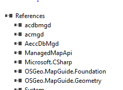
This is from a current vs2013 project for civil 3d. The required references are in C:\Program Files\Autodesk\AutoCAD Civil 3D 2012.
- Mark as New
- Bookmark
- Subscribe
- Mute
- Subscribe to RSS Feed
- Permalink
- Report
Now with the 2015 release, I would suggest you take a look at this version before, we made some significant changes.
- Mark as New
- Bookmark
- Subscribe
- Mute
- Subscribe to RSS Feed
- Permalink
- Report
I will thanks. Unfortunately our company is getting ready to move to 2014, it will be this time next year that we will be at the 2015 point, IF they decide to upgrade. So I will still have to see if I can rig something up so that it is useful for the next year for our users.
thanks
cj
- Mark as New
- Bookmark
- Subscribe
- Mute
- Subscribe to RSS Feed
- Permalink
- Report
Can you provide some more information on how to use the GeoLocationData class? For example, I am looking for the "current" coordinate system (Autodesk.AutoCAD.DatabaseServices.GeoLocationData.CoordinateSystem.get).
This is referenced from Civil 3D 2014 acdbmgd.
- Subscribe to RSS Feed
- Mark Topic as New
- Mark Topic as Read
- Float this Topic for Current User
- Bookmark
- Subscribe
- Printer Friendly Page


