Community
- Forums Home
- >
- Infrastructure Map Server Community
- >
- Infrastructure Map Server Forum
- >
- Re: the coordinate system initialization error
Infrastructure Map Server Forum
Welcome to Autodesk’s Infrastructure Map Server Forums. Share your knowledge, ask questions, and explore popular Infrastructure Map Server topics.
Turn on suggestions
Auto-suggest helps you quickly narrow down your search results by suggesting possible matches as you type.
Reply
Topic Options
- Subscribe to RSS Feed
- Mark Topic as New
- Mark Topic as Read
- Float this Topic for Current User
- Bookmark
- Subscribe
- Printer Friendly Page
Message 1 of 3
Anonymous
1857 Views, 2 Replies
04-17-2012
02:28 AM
- Mark as New
- Bookmark
- Subscribe
- Mute
- Subscribe to RSS Feed
- Permalink
- Report
04-17-2012
02:28 AM
the coordinate system initialization error
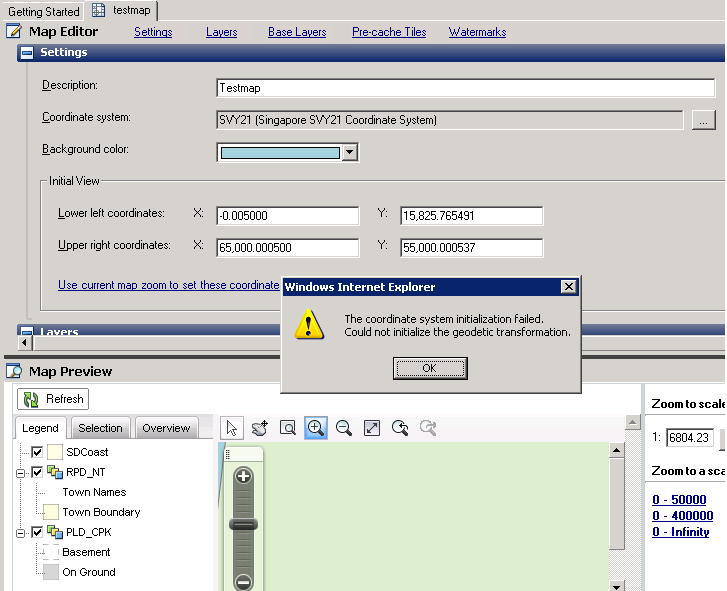
I am using MAPSERVER 2012 and created a map by SVY21 coordinate system. It works fine in one server and in another server i get an error like "THE COORDINATE SYSTEM INITIALIZATION FAILED. COULD NOT INITIALIZE THE GEODETIC TRANSFORMATION" i dont know how to solve this problem. I searched a lot for a solution but no luck. Please help me out.
2 REPLIES 2
Message 2 of 3
Anonymous
in reply to:
Anonymous
04-17-2012
11:19 PM
- Mark as New
- Bookmark
- Subscribe
- Mute
- Subscribe to RSS Feed
- Permalink
- Report
04-17-2012
11:19 PM
Do you have an existing installation of an older version of MapGuide/AIMS/AutoCAD Map?
It may be using it's (older) coordinate system dictionaries
- Jackie
Message 3 of 3
Anonymous
in reply to:
Anonymous
04-18-2012
06:47 PM
- Mark as New
- Bookmark
- Subscribe
- Mute
- Subscribe to RSS Feed
- Permalink
- Report
04-18-2012
06:47 PM
I am using AutoCad 2012. Only when i add few layers it shows me this error. Few layers work and other layers like buildings and road are not seen and they keep showing this error when i zoom in. These layers were copied from the exciting working server. Is there anything else i have to check because i have no clue from where the error is coming.
Reply
Topic Options
- Subscribe to RSS Feed
- Mark Topic as New
- Mark Topic as Read
- Float this Topic for Current User
- Bookmark
- Subscribe
- Printer Friendly Page
