Community
- Forums Home
- >
- Infrastructure Map Server Community
- >
- Infrastructure Map Server Forum
- >
- Re: Autodesk Infrastructure GeoREST Extension 2012 - 64BIT
Infrastructure Map Server Forum
Welcome to Autodesk’s Infrastructure Map Server Forums. Share your knowledge, ask questions, and explore popular Infrastructure Map Server topics.
Turn on suggestions
Auto-suggest helps you quickly narrow down your search results by suggesting possible matches as you type.
Autodesk Infrastructure GeoREST Extension 2012 - 64BIT
16 REPLIES 16
SOLVED
Reply
Topic Options
- Subscribe to RSS Feed
- Mark Topic as New
- Mark Topic as Read
- Float this Topic for Current User
- Bookmark
- Subscribe
- Printer Friendly Page
Message 1 of 17
11-22-2011
02:56 PM
- Mark as New
- Bookmark
- Subscribe
- Mute
- Subscribe to RSS Feed
- Permalink
- Report
11-22-2011
02:56 PM
In the Preview stuff (technical term) - the GeoRest is installed.from the C:\Autodesk\Autodesk_Infrastructure_Map_Server_2012_English_Win_64bit\TechnologyPreview
I have it working great on IIS for direct connect (i.e. FDO Features) but when I connect to AIMS 2012 - I get "MgConnectionFailedException".
I know GeoRest is configured ok since it works with direct connect data (i.e. path to SDF or ConnectString to SQL Server).
I am testing with the config.xml that comes with the GeoRest and points to the sample dataset (installed).
<Resource uripart="propertymap">
<Source type="MapGuide">
<FeatureSource>Library://Samples/Sheboygan/Data/Parcels.FeatureSource</FeatureSource>
<FeatureClass>SHP_Schema:Parcels</FeatureClass>
</Source>
I know I have Library://Samples/Sheboygan/Data/Parcels.FeatureSource available.
Any tips?
gordon
Solved! Go to Solution.
Solved by gluckett. Go to Solution.
16 REPLIES 16
Message 2 of 17
12-11-2011
05:48 PM
- Mark as New
- Bookmark
- Subscribe
- Mute
- Subscribe to RSS Feed
- Permalink
- Report
12-11-2011
05:48 PM
Discovered the issue. The ports changed with AIMS 2012.
Old connection
<Resourceuripart="property">
     <Sourcetype="MapGuide">
      <FeatureSource>Library://Samples/Sheboygan/Data/Parcels.FeatureSource</FeatureSource>
      <FeatureClass>SHP_Schema:Parcels</FeatureClass>
      <ServerIp>192.168.0.33</ServerIp>
      <ServerPort>2812</ServerPort>
     </Source>
   </Resource>
NOW WITH AIMS 2012 the server port is "2822"
<Resourceuripart="property">
     <Sourcetype="MapGuide">
      <FeatureSource>Library://Samples/Sheboygan/Data/Parcels.FeatureSource</FeatureSource>
      <FeatureClass>SHP_Schema:Parcels</FeatureClass>
      <ServerIp>192.168.0.33</ServerIp>
      <ServerPort>2822</ServerPort>
     </Source>
   </Resource>
Message 3 of 17
01-19-2014
10:02 PM
- Mark as New
- Bookmark
- Subscribe
- Mute
- Subscribe to RSS Feed
- Permalink
- Report
01-19-2014
10:02 PM
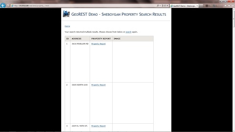
Now I'm able to access the source type "mapguide" and use the example "Property" parameters via the url http://localhost/rest/data/property_/11530.html
The attribute were displayed without problem, but it can't to generate the map image!
<tr>
<td width="200">Image Representation</td>
<td><a href="../www/Image/{{PROPERTY_Autogenerated_SDF_ID}}.png">{{PROPERTY_Autogenerated_SDF_ID}}.png</a></td>
</tr>
Anyone have idea? Thanks.
Message 4 of 17
01-20-2014
06:41 AM
- Mark as New
- Bookmark
- Subscribe
- Mute
- Subscribe to RSS Feed
- Permalink
- Report
01-20-2014
06:41 AM
Make sure that line 83 "Image" is configured.
C:\Program Files\Autodesk\Autodesk Infrastructure Web Server Extension 2014\www\GeoREST\conf\SheboyganMap\restcfg.xml
This uses the AIMS Sheboygan map to get the image.
http://localhost/rest/data/Image/11530.png
Message 5 of 17
01-20-2014
06:52 PM
- Mark as New
- Bookmark
- Subscribe
- Mute
- Subscribe to RSS Feed
- Permalink
- Report
01-20-2014
06:52 PM
Thanks.
I did changed the serverport. The error message "Failed to retrieve message for "MgConnectionFailedException"." is disappear, but the image cannot be generated properly! The webpage(http://127.0.0.1/rest/data/Image/1.png) is empty in IE7. I think the problem is the PNG image generation. 😞
Message 6 of 17
01-23-2014
09:01 AM
- Mark as New
- Bookmark
- Subscribe
- Mute
- Subscribe to RSS Feed
- Permalink
- Report
01-23-2014
09:01 AM
Make sure you have the correct ServerIp and ServerPort for your AIMS install for that data in AIMS for the image.
Message 7 of 17
01-23-2014
05:44 PM
- Mark as New
- Bookmark
- Subscribe
- Mute
- Subscribe to RSS Feed
- Permalink
- Report
01-23-2014
05:44 PM
Thanks. I did tried to update the serverconfig, webconfig, restcfg files. Which file should I update for the image path setting? 🙂
Message 8 of 17
01-24-2014
08:21 AM
- Mark as New
- Bookmark
- Subscribe
- Mute
- Subscribe to RSS Feed
- Permalink
- Report
01-24-2014
08:21 AM
The image component comes from the config file
C:\Program
Files\Autodesk\Autodesk Infrastructure Web Server Extension
2014\www\GeoREST\conf\SheboyganMap\restcfg.xml
Around line 83
<Resource uripart="Image">
<Source type="MapGuide">
<FeatureSource>Library://Samples/Sheboygan/Data/Parcels.FeatureSource</FeatureSource>
<FeatureClass>SHP_Schema:Parcels</FeatureClass>
<ServerIp>127.0.0.1</ServerIp>
<ServerPort>2812</ServerPort>
</Source>
be sure that the Port is correct. Check out your serverconfig.ini to ensure 2812 is correct...
Message 9 of 17
01-29-2014
01:44 AM
- Mark as New
- Bookmark
- Subscribe
- Mute
- Subscribe to RSS Feed
- Permalink
- Report
01-29-2014
01:44 AM
Thanks.
I think it seems that it is caused by the image path, because I tried to change the server ip or server port of the rectcfg file. The image box will show a cross symbol in IE browser, if the wrong port was used. The following screen capture shows the difference server port were used.
Message 10 of 17
01-29-2014
06:19 AM
- Mark as New
- Bookmark
- Subscribe
- Mute
- Subscribe to RSS Feed
- Permalink
- Report
01-29-2014
06:19 AM
So the MGP for Sheboygan was loaded on your AIMS server in the default folders?
The PORT is correct?
In my class at AU, I use the defualt Autodesk installs and tweak the xml to ensure it is correctly installed.
The "IMAGE" path requires that Sheboygan is available and that you are using AIMS (with IIS).
Message 11 of 17
01-29-2014
08:10 PM
- Mark as New
- Bookmark
- Subscribe
- Mute
- Subscribe to RSS Feed
- Permalink
- Report
01-29-2014
08:10 PM
Eventually it works! The map can be generated, but it is only support the feature type which is the polygon type! Is it true? Once I used the point feature, the message "Failed to retrieve message for "MgInvalidArgumentException". [SETVIEWSCALE] = "0" Failed to retrieve message for "MgValueCannotBeLessThanOrEqualToZero"." will prompt.
Message 12 of 17
03-31-2014
03:11 PM
- Mark as New
- Bookmark
- Subscribe
- Mute
- Subscribe to RSS Feed
- Permalink
- Report
03-31-2014
03:11 PM
Hi 🙂
I don't know if you noticed that GeoRest actually generate PNG/JPEG images slowly. It took about 30 secs to generate every PNG images in my case.
Therefore, you will not see the images showed up properly on your GeoRest many/single template pages.
In my opinion, you can probably use C# or other programming languages to create a small GeoRest images pre-geneartion application to generate all the images that you need.
The code will be very similar as following:
int start = Int32.Parse(StarttextBox.Text);
int end = Int32.Parse(EndtextBox.Text);
for (int i = start; i <= end; i++)
{
string sourceUrl = @"http://localhost/rest/data/test/" + i.ToString() + ".png";
string localPath = @"C:\inetpub\wwwroot\test\png\" + i.ToString() + ".png";
byte[] imageBytes;
HttpWebRequest imageRequest = (HttpWebRequest)WebRequest.Create(sourceUrl);
WebResponse imageResponse = imageRequest.GetResponse();
Stream responseStream = imageResponse.GetResponseStream();
using (BinaryReader br = new BinaryReader(responseStream))
{
imageBytes = br.ReadBytes(500000);
br.Close();
}
responseStream.Close();
imageResponse.Close();
FileStream fs = new FileStream(localPath, FileMode.Create);
BinaryWriter bw = new BinaryWriter(fs);
try
{
bw.Write(imageBytes);
}
finally
{
fs.Close();
bw.Close();
}
Hope that will help you 🙂
Message 13 of 17
04-04-2014
09:20 AM
- Mark as New
- Bookmark
- Subscribe
- Mute
- Subscribe to RSS Feed
- Permalink
- Report
04-04-2014
09:20 AM
For those stuggling with the GeoRest bundled with AIMS, I also would recommend the new mapguide-rest project started by Jackie Ng.
It is dead easy to set up and works really quickly.
It uses AIMS 100% (sorry no direct connect to FDO) - but it is very slick and faster than GeoREST.
http://themapguyde.blogspot.ca/2014/02/introducing-mapguide-rest-new-rest.html
https://github.com/jumpinjackie/mapguide-rest
It is dead easy to set up and works really quickly.
It uses AIMS 100% (sorry no direct connect to FDO) - but it is very slick and faster than GeoREST.
http://themapguyde.blogspot.ca/2014/02/introducing-mapguide-rest-new-rest.html
https://github.com/jumpinjackie/mapguide-rest
Message 14 of 17
04-06-2014
06:14 PM
- Mark as New
- Bookmark
- Subscribe
- Mute
- Subscribe to RSS Feed
- Permalink
- Report
04-06-2014
06:14 PM
Before anybody gets too excited, mapguide-rest is not production-ready yet.
There's still some security hardening to be done before I can safely say that you can put this to production use.
Sure, download the current release to have a play around and see what it can do, but I strongly discourage production deployment at this point in time, especially on public-facing MapGuide/AIMS installations.
- Jackie
Message 15 of 17
04-10-2014
06:19 AM
- Mark as New
- Bookmark
- Subscribe
- Mute
- Subscribe to RSS Feed
- Permalink
- Report
04-10-2014
06:19 AM
Still, your prototype ("Alpha") is very promising and slick. We should all keep an eye on the mapguide-rest project.
Message 16 of 17
06-04-2014
12:10 AM
- Mark as New
- Bookmark
- Subscribe
- Mute
- Subscribe to RSS Feed
- Permalink
- Report
06-04-2014
12:10 AM
Is there someone try to use the post/ put of georest? I want to update/ create a new entries for the specific SDF connection. How can I generate the SHPGEOM from the fusion viewer? 🙂
<Name>SHPGEOM</Name>
<Value>
POLYGON ((-87.750602148149582 43.772512943108723, -87.750820980626941 43.772509600594994,
-87.751112034446564 43.772505154303111, -87.751191267124568 43.772701180970984, -87.750821769925366
43.772706826945878, -87.750681379906538 43.77270897188734, -87.750664555803112 43.772667347110961,
-87.750602148149582 43.772512943108723))
Message 17 of 17
06-04-2014
06:26 AM
- Mark as New
- Bookmark
- Subscribe
- Mute
- Subscribe to RSS Feed
- Permalink
- Report
06-04-2014
06:26 AM
Check out the classic GeoREST (Comes with AIMS) how to put post and get data to a SDF or SHP.
He is my presentation at Autodesk University.
Reply
Topic Options
- Subscribe to RSS Feed
- Mark Topic as New
- Mark Topic as Read
- Float this Topic for Current User
- Bookmark
- Subscribe
- Printer Friendly Page
