Community
AutoCAD Map 3D Forum
Welcome to Autodesk’s AutoCAD Map 3D Forums. Share your knowledge, ask questions, and explore popular AutoCAD Map 3D topics.
Turn on suggestions
Auto-suggest helps you quickly narrow down your search results by suggesting possible matches as you type.
Reply
Topic Options
- Subscribe to RSS Feed
- Mark Topic as New
- Mark Topic as Read
- Float this Topic for Current User
- Bookmark
- Subscribe
- Printer Friendly Page
Message 1 of 9
Anonymous
1044 Views, 8 Replies
04-17-2012
07:51 AM
- Mark as New
- Bookmark
- Subscribe
- Mute
- Subscribe to RSS Feed
- Permalink
- Report
04-17-2012
07:51 AM
Is there a way of trimming an SDF or SHP file with multiple polygons within a boundary buffer zone, but keep the enire of all of the crossing polygons.
I have managed to create a feautre overlay for the trimming selection but the 'Union' command creates a new layer with all of both SDF files I'm comparing, not just the ones within the buffer zone.
Solved! Go to Solution.
Solved by parkr4st. Go to Solution.
8 REPLIES 8
Message 2 of 9
04-17-2012
07:58 AM
- Mark as New
- Bookmark
- Subscribe
- Mute
- Subscribe to RSS Feed
- Permalink
- Report
04-17-2012
07:58 AM
Hi,
if I'm understanding that correctly you now have a new SDF that is the result of the overlay. This new SDF should contain fields that identify the ID of the polygon in SDF-A and the ID of the polygon in SDF-B (SDF-A and SDF-B were the two FDO-sources you overlayed).
You can now filter for all polygons on your result-SDF were the ID of SDF-B is null (when SDF-B was the one with the trim-polygon).
HTH, - alfred -
------------------------------------------------------------------------------------
Alfred NESWADBA
ISH-Solutions GmbH / Ingenieur Studio HOLLAUS
www.ish-solutions.at ... blog.ish-solutions.at ... LinkedIn ... CDay 2024
------------------------------------------------------------------------------------

(not an Autodesk consultant)
Alfred NESWADBA
ISH-Solutions GmbH / Ingenieur Studio HOLLAUS
www.ish-solutions.at ... blog.ish-solutions.at ... LinkedIn ... CDay 2024
------------------------------------------------------------------------------------
(not an Autodesk consultant)
Message 3 of 9
04-17-2012
08:04 AM
- Mark as New
- Bookmark
- Subscribe
- Mute
- Subscribe to RSS Feed
- Permalink
- Report
04-17-2012
08:04 AM
Hi Alfred,
The problem is we have 1 'multi-polygon' SHP file & 1 'corridor' SHP file
We are trying to remove everything outside the corridor and keep everything within AND intersecting with the corridor.
We just need 1 final SHP file with only the internal polylines remaining
Hope this clears up the query.
Thanks
Message 4 of 9
04-17-2012
08:34 AM
- Mark as New
- Bookmark
- Subscribe
- Mute
- Subscribe to RSS Feed
- Permalink
- Report
04-17-2012
08:34 AM
Hi,
ok, run these two SHPs through the overlay ==> I think identy should be the correct overlay-method.
The result is a new SDF divided on all borders from both SHP's, and the attributes from both SHPs also.
No disable the original two shapes from beeing displayed
On the resulting SDF use a filter that checks for OriginalIDFromCorridor is not null. Now you should see the resulting polygons just in the area of your corridor.
Hope that I described it enough and you can follow on it. If not - and you are allowd - upload your two shapes and I create a video that shows you what to do (that with German Map3D as I don't have an english one, but the UI is similar to be able to find the same buttons then on your Map3D).
- alfred -
------------------------------------------------------------------------------------
Alfred NESWADBA
ISH-Solutions GmbH / Ingenieur Studio HOLLAUS
www.ish-solutions.at ... blog.ish-solutions.at ... LinkedIn ... CDay 2024
------------------------------------------------------------------------------------
(not an Autodesk consultant)
Alfred NESWADBA
ISH-Solutions GmbH / Ingenieur Studio HOLLAUS
www.ish-solutions.at ... blog.ish-solutions.at ... LinkedIn ... CDay 2024
------------------------------------------------------------------------------------
(not an Autodesk consultant)
Message 5 of 9
04-17-2012
08:56 AM
- Mark as New
- Bookmark
- Subscribe
- Mute
- Subscribe to RSS Feed
- Permalink
- Report
04-17-2012
08:56 AM
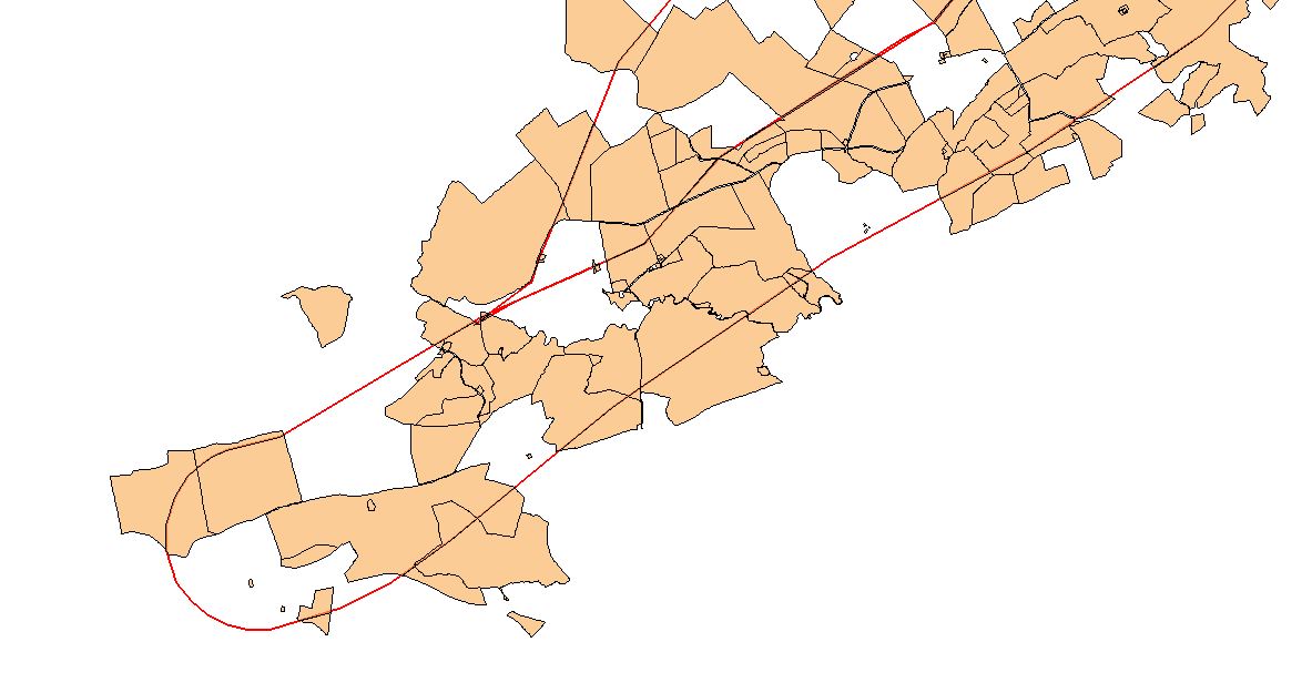
Hi Alfred,
The identify command just gives us an exact copy of the starting SHP file.
Are we using the correct command? We basically need one final SHP file with anything within or touching the boundary (not trimmed to it but the whole land parcel)
We have a corridor SHP shown red and the land is the rest on the screen shot.
I didnt understand what you meant by "OriginalIDFromCorridor" how do we switch this on/off?
Message 6 of 9
04-17-2012
10:02 AM
- Mark as New
- Bookmark
- Subscribe
- Mute
- Subscribe to RSS Feed
- Permalink
- Report
04-17-2012
10:02 AM
Hi,
>> with anything within or touching the boundary (not trimmed to it but the whole land parcel)
Ok, sorry I misunderstood that.
So look to this video how I would do that,
- first do a geographical filter using the polygon ==> that reduces the number of displayed elements to "completly within corridor"
- then you can export this into a new SDF
- alfred -
------------------------------------------------------------------------------------
Alfred NESWADBA
ISH-Solutions GmbH / Ingenieur Studio HOLLAUS
www.ish-solutions.at ... blog.ish-solutions.at ... LinkedIn ... CDay 2024
------------------------------------------------------------------------------------
(not an Autodesk consultant)
Alfred NESWADBA
ISH-Solutions GmbH / Ingenieur Studio HOLLAUS
www.ish-solutions.at ... blog.ish-solutions.at ... LinkedIn ... CDay 2024
------------------------------------------------------------------------------------
(not an Autodesk consultant)
Message 7 of 9
Anonymous
in reply to:
Anonymous
04-18-2012
12:39 AM
- Mark as New
- Bookmark
- Subscribe
- Mute
- Subscribe to RSS Feed
- Permalink
- Report
04-18-2012
12:39 AM
Alfred,
I did figure this way out in the end but this still erases items that are crossing the boundary of the corridor. For example if a parcel of land is on the boundary half within or half out I need the whole parcel to remain behind along with all the parcels within the corridor and erase anything that isnt within or touching the corridor. This is my main headache.
Regards
Message 8 of 9
04-18-2012
02:11 AM
- Mark as New
- Bookmark
- Subscribe
- Mute
- Subscribe to RSS Feed
- Permalink
- Report
04-18-2012
02:11 AM
a query when you data attach and add with a query by location should give the result set you want. you can then save that set to a sdf and should be done. the location should be "touching the corridor" if I understand your question.
Dave
Reply
Topic Options
- Subscribe to RSS Feed
- Mark Topic as New
- Mark Topic as Read
- Float this Topic for Current User
- Bookmark
- Subscribe
- Printer Friendly Page
Forums Links
Can't find what you're looking for? Ask the community or share your knowledge.
Post to forums
