Community
- Forums Home
- >
- AutoCAD Map 3D Community
- >
- AutoCAD Map 3D Forum
- >
- Re: Unable to conect to excel file using ODBC FDO provider
AutoCAD Map 3D Forum
Welcome to Autodesk’s AutoCAD Map 3D Forums. Share your knowledge, ask questions, and explore popular AutoCAD Map 3D topics.
Turn on suggestions
Auto-suggest helps you quickly narrow down your search results by suggesting possible matches as you type.
Unable to conect to excel file using ODBC FDO provider
11 REPLIES 11
SOLVED
Reply
Topic Options
- Subscribe to RSS Feed
- Mark Topic as New
- Mark Topic as Read
- Float this Topic for Current User
- Bookmark
- Subscribe
- Printer Friendly Page
Message 1 of 12
04-20-2012
12:14 PM
- Mark as New
- Bookmark
- Subscribe
- Mute
- Subscribe to RSS Feed
- Permalink
- Report
04-20-2012
12:14 PM
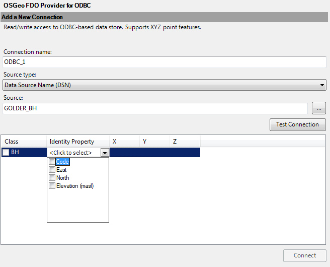
I have an excel spreadsheet of boreholes. The spreadsheet has the format of ID, X, Y, Z
I have tried using the 'Connect to Data' feature in Map 3D 2012 64 bit.
The ODBC connection is created and tests correctly. After connecting to the ODBC DSN and loggin in, I am able to see the fields identified in the excel file. There is also the Class available from the named range in the excel spreadsheet.
I select my Identity Property, X, Y, and Z - but that's as far as I can go. I have no opportunity to set the coordinate system and the 'connect' button does not activate.
Using Win 7 64 bit - and I have the 64 bit ODBC driver's installed.
Any ideas?
Thanks,
Chris
Solved! Go to Solution.
Solved by chierchio. Go to Solution.
11 REPLIES 11
Message 4 of 12
04-20-2012
01:38 PM
- Mark as New
- Bookmark
- Subscribe
- Mute
- Subscribe to RSS Feed
- Permalink
- Report
04-20-2012
01:38 PM
It's on my list to check out since I have some well data & corresponding spreadsheets. I'll update when I've played with it. The named range key came from one of my older postings and sending my files to AD for them to review since I was having a similar problem with FDO to ODBC with 64bit OS....
Message 5 of 12
04-25-2012
08:19 AM
- Mark as New
- Bookmark
- Subscribe
- Mute
- Subscribe to RSS Feed
- Permalink
- Report
04-25-2012
08:19 AM
O.K., I'm working with my data set again. I've set up a "Named Range" in Excel and used the ODBC data source administrator with the 64-bit MS Access database engine installed. I can FDO connect to the ODBC data source, when I connect to data, the named range shows up in the connection. This is strictly a data table to color code various water contaminant MCL's for drinking water that I intend to join to my well points data set. So, no coordinates within my Excel data. When I connect to the data, I see the data column headers, but no data. So, is this what's happening to you????
I'm in need of more help on this myself - I can send it over to my colleague using E$RI, but I'd rather keep it in my own formats.....
Message 6 of 12
04-25-2012
08:37 AM
- Mark as New
- Bookmark
- Subscribe
- Mute
- Subscribe to RSS Feed
- Permalink
- Report
04-25-2012
08:37 AM
I have an excel table with a named range and do not see anythng, nor am I able to check the class box. It is tricky to select the Identity property as well... it keeps wanting to go to <Click to select>. The excel table does have merged cells - though not in the named range. I have tried another excel table with just simple X,Y,Z and I am getting a result the same as you have described.. no data.
Seems like this is a bug with the OSGeo FDO Provider.
I can connect to the table using the Attach Data Source command in Map3D, but I cannot locate these as points in the drawing.
Looking forward to a resolution - good luck!
Chris
Message 7 of 12
05-03-2012
09:45 AM
- Mark as New
- Bookmark
- Subscribe
- Mute
- Subscribe to RSS Feed
- Permalink
- Report
05-03-2012
09:45 AM
Chris,
I'm still fighting with it here - per discussion with AD, I was told my problem is the lack of a unique key. I've created a new column of ID's in my spreadsheet, but don't get the same connection window. Specifically, I don't have an opportunity to select the identifier field. What version are you using?
Message 9 of 12
05-03-2012
12:53 PM
- Mark as New
- Bookmark
- Subscribe
- Mute
- Subscribe to RSS Feed
- Permalink
- Report
05-03-2012
12:53 PM
O.K. so I seem to be having success seeing the full table now - key was upgrading to 2012 & having a unique identifier column of data...
Message 11 of 12
05-03-2012
01:03 PM
- Mark as New
- Bookmark
- Subscribe
- Mute
- Subscribe to RSS Feed
- Permalink
- Report
05-03-2012
01:03 PM
in this case, the data is extended attributes (water quality sampling for MCL's) against existing wells. Since the I'm attaching to a .SHP from the state well data set, I'm intending to perform a join to stylize points based on the sampling results. so, I haven't tried to add points by their coordinates. When I have some time, I'lll try & let you know what happens.
TdH
Message 12 of 12
05-05-2012
08:01 AM
- Mark as New
- Bookmark
- Subscribe
- Mute
- Subscribe to RSS Feed
- Permalink
- Report
05-05-2012
08:01 AM
I was finally able to connect to the excel file and map the points.
There was a duplicate point in the spreadsheet that I missed. Created another column with IDX(index) and everything works now.
Thanks for your input.
C
Reply
Topic Options
- Subscribe to RSS Feed
- Mark Topic as New
- Mark Topic as Read
- Float this Topic for Current User
- Bookmark
- Subscribe
- Printer Friendly Page

