Community
AutoCAD Map 3D Forum
Welcome to Autodesk’s AutoCAD Map 3D Forums. Share your knowledge, ask questions, and explore popular AutoCAD Map 3D topics.
Turn on suggestions
Auto-suggest helps you quickly narrow down your search results by suggesting possible matches as you type.
Reply
Topic Options
- Subscribe to RSS Feed
- Mark Topic as New
- Mark Topic as Read
- Float this Topic for Current User
- Bookmark
- Subscribe
- Printer Friendly Page
Message 1 of 18
02-27-2013
02:48 PM
- Mark as New
- Bookmark
- Subscribe
- Mute
- Subscribe to RSS Feed
- Permalink
- Report
02-27-2013
02:48 PM
Overlay Analysis
Help
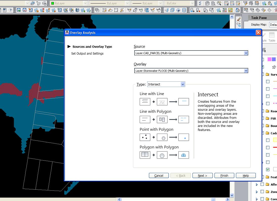
I am trying to perform an OVERLAY ANALYSIS between a flood polygon and parcel polygon. I want to highlight the parcels that intersect with the flood polygon. I select SOURCE as Parcels and OVERLAY as the Food Polygon. When I perform the operation I get a result SDF that shows that area of the parcel that is flood affected. Am I missing something... I need the whole of the parcel selected..
Paul
17 REPLIES 17
Message 2 of 18
02-27-2013
03:03 PM
- Mark as New
- Bookmark
- Subscribe
- Mute
- Subscribe to RSS Feed
- Permalink
- Report
02-27-2013
03:03 PM
Hi,
you should not use "Intersect" as overlay type (you see it already on the icons in the dialog that not all geometry will be in the resulting GIS-dataset).

Instead you could try "Union" (hoping to have translated my German words correct to the Map3D-English), well I do understand the word "Union" in another way, but at least verify the resulting icons in the preview:

HTH, - alfred -
------------------------------------------------------------------------------------
Alfred NESWADBA
ISH-Solutions GmbH / Ingenieur Studio HOLLAUS
www.ish-solutions.at ... blog.ish-solutions.at ... LinkedIn ... CDay 2024
------------------------------------------------------------------------------------

(not an Autodesk consultant)
Alfred NESWADBA
ISH-Solutions GmbH / Ingenieur Studio HOLLAUS
www.ish-solutions.at ... blog.ish-solutions.at ... LinkedIn ... CDay 2024
------------------------------------------------------------------------------------
(not an Autodesk consultant)
Message 3 of 18
02-27-2013
03:48 PM
- Mark as New
- Bookmark
- Subscribe
- Mute
- Subscribe to RSS Feed
- Permalink
- Report
02-27-2013
03:48 PM
Union does not provide the desires result. All the Help funstions show that using INTERSECT will provide what I am looking for. even when hovering over the GIS OVERLAY icon, the video that plays is what I am looking for.
Message 4 of 18
02-27-2013
11:52 PM
- Mark as New
- Bookmark
- Subscribe
- Mute
- Subscribe to RSS Feed
- Permalink
- Report
02-27-2013
11:52 PM
Hi,
I'm not sure whether I do understand what you want to do or what exactly the issue is - but to me it looks like you need something like a Spatial Query. What you are doing right now is spatial geoprocessing - and the information displayed in the dialog box you provided says "non-oberlapping areas are discarded". Isn't that excatly what happened?
The spatial query capabilities in Map are still poor. You can select feature based on a window a polygon but you cannot query features based on a second set of features.
QGIS does this quite well have look here at this tutorial - scroll down a bit for "Spatial Query". The parcel affected but flooding would be selected - I assume thats waht you want to get as well?
http://qgis.spatialthoughts.com/2011/12/tutorial-performing-spatial-queries-in.html
Rob
Message 5 of 18
02-28-2013
12:18 AM
- Mark as New
- Bookmark
- Subscribe
- Mute
- Subscribe to RSS Feed
- Permalink
- Report
02-28-2013
12:18 AM
Hi,
>> You can select feature based on a window a polygon
>> but you cannot query features based on a second set of features
Excuse me for interupting, but you don't need any third party software and export and import and ... to do that!
Look to my video, there are some parcels, one buffer object for a power supply line.
I do just one additional rule in the display-style for the parcels to get the parcels colorized in another color that are touched from this buffer object. (sorry that it is in German, but the icons and commands are the same)
- alfred -
------------------------------------------------------------------------------------
Alfred NESWADBA
ISH-Solutions GmbH / Ingenieur Studio HOLLAUS
www.ish-solutions.at ... blog.ish-solutions.at ... LinkedIn ... CDay 2024
------------------------------------------------------------------------------------
(not an Autodesk consultant)
Alfred NESWADBA
ISH-Solutions GmbH / Ingenieur Studio HOLLAUS
www.ish-solutions.at ... blog.ish-solutions.at ... LinkedIn ... CDay 2024
------------------------------------------------------------------------------------
(not an Autodesk consultant)
Message 6 of 18
02-28-2013
12:31 AM
- Mark as New
- Bookmark
- Subscribe
- Mute
- Subscribe to RSS Feed
- Permalink
- Report
02-28-2013
12:31 AM
Hi Alfred,
it is as I wrote - you can select features based on a polygon (=buffer) not based on a set of features. With your approach you need to select the buffer manually and as further limitation you can select only one polygon/buffer at a time. That works well for simple use cases though.
Rob
Message 7 of 18
02-28-2013
06:58 AM
- Mark as New
- Bookmark
- Subscribe
- Mute
- Subscribe to RSS Feed
- Permalink
- Report
02-28-2013
06:58 AM
Hi,
>> not based on a set of features
Ok, so it's how terms are used and sorry, I am wrong because I misunderstood the meaning or "features" how you used it.
In that case I would do an overlay and have the attributes of both "sets of features" in a new "set of features" and that gives me the aibility to get the touched parcels selected. (hopefully I have now used the correct words 😉 )
- alfred -
------------------------------------------------------------------------------------
Alfred NESWADBA
ISH-Solutions GmbH / Ingenieur Studio HOLLAUS
www.ish-solutions.at ... blog.ish-solutions.at ... LinkedIn ... CDay 2024
------------------------------------------------------------------------------------
(not an Autodesk consultant)
Alfred NESWADBA
ISH-Solutions GmbH / Ingenieur Studio HOLLAUS
www.ish-solutions.at ... blog.ish-solutions.at ... LinkedIn ... CDay 2024
------------------------------------------------------------------------------------
(not an Autodesk consultant)
Message 8 of 18
03-01-2013
08:23 AM
- Mark as New
- Bookmark
- Subscribe
- Mute
- Subscribe to RSS Feed
- Permalink
- Report
03-01-2013
08:23 AM
Hi,
if you use MAPFEATUREMERGE command you can merge all features from 1st layer into one single feature (multi-polygon) and then used method explained by alfred.
I've seen your video and I've a question. I've tried to modify the geometry of buffer after creating the rule, but new overlapped parcels are not colored. It seems that the rule use (store) the coordinates of buffer when it's selected, and not the ID of feature. So overlay is not updated (dynamic) when geometry of buffer is modified. Is it right?
Olivier
Message 9 of 18
03-01-2013
08:37 AM
- Mark as New
- Bookmark
- Subscribe
- Mute
- Subscribe to RSS Feed
- Permalink
- Report
03-01-2013
08:37 AM
Hi,
>> It seems that the rule use (store) the coordinates of buffer when it's selected, and not the ID of feature
Sorry and sadly, yes you are right, it's just a snapshot from the vertex-coordinates of the polygon.
But if you need to do that more than once you have the aibility of the Map-Workflow to automate this overlaying.
- alfred -
------------------------------------------------------------------------------------
Alfred NESWADBA
ISH-Solutions GmbH / Ingenieur Studio HOLLAUS
www.ish-solutions.at ... blog.ish-solutions.at ... LinkedIn ... CDay 2024
------------------------------------------------------------------------------------
(not an Autodesk consultant)
Alfred NESWADBA
ISH-Solutions GmbH / Ingenieur Studio HOLLAUS
www.ish-solutions.at ... blog.ish-solutions.at ... LinkedIn ... CDay 2024
------------------------------------------------------------------------------------
(not an Autodesk consultant)
Message 10 of 18
04-29-2013
11:06 AM
- Mark as New
- Bookmark
- Subscribe
- Mute
- Subscribe to RSS Feed
- Permalink
- Report
04-29-2013
11:06 AM
@Anonymous wrote:Help
I am trying to perform an OVERLAY ANALYSIS between a flood polygon and parcel polygon. I want to highlight the parcels that intersect with the flood polygon. I select SOURCE as Parcels and OVERLAY as the Food Polygon. When I perform the operation I get a result SDF that shows that area of the parcel that is flood affected. Am I missing something... I need the whole of the parcel selected..
Paul
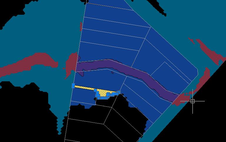
I am trying to do the same thing. I have a SDF of buildings and a SDF of the flood zones. I want to get all of the buildings that are in a flood zone. When I do the feature overlay, I did Intersect because that's what the help files show would be what I want. However, the result is the buildings (source), but clipped to the boundary of the flood zone (overlay boundary). You can see what happened below in purple. I just want the buildings that intersect the flood zone, but not clipped. The result seems more like what the type Clip should be, not Intersect.

I tried using Union, but it's basically the same thing. It splits the building along the flood zone line and creates two polygons instead of just returning the building's polygon.
How can I get just the buildings that are completely within and intersect the flood zone without the building being clipped?
C3D 2022-2025
Windows 11
32GB RAM
Windows 11
32GB RAM
Message 11 of 18
04-29-2013
04:58 PM
- Mark as New
- Bookmark
- Subscribe
- Mute
- Subscribe to RSS Feed
- Permalink
- Report
04-29-2013
04:58 PM
Set your feature edits options to "Check out Features as AutoCAD enities. Then use the Query To filter data, select locate on map then pick inside or touching polygon, Ok. When it asks for the polygon use the select option and pick on the flood zone polygon feature. Then save the selected layer to a new SDF file.
Murph
Supporting the troops daily.

Supporting the troops daily.
Message 12 of 18
04-30-2013
05:05 AM
- Mark as New
- Bookmark
- Subscribe
- Mute
- Subscribe to RSS Feed
- Permalink
- Report
04-30-2013
05:05 AM
@Anonymous wrote:Set your feature edits options to "Check out Features as AutoCAD enities. Then use the Query To filter data, select locate on map then pick inside or touching polygon, Ok. When it asks for the polygon use the select option and pick on the flood zone polygon feature. Then save the selected layer to a new SDF file.
I saw where I can use a single polygon to do the selection. The problem is there are a lot of polygons that make up the flood zones. Do I have to do a OR statement for every single polygon that makes up the flood zones? If so, then no wonder ESRI is so popular considering this should be a basic GIS function.
C3D 2022-2025
Windows 11
32GB RAM
Windows 11
32GB RAM
Message 14 of 18
04-30-2013
12:20 PM
- Mark as New
- Bookmark
- Subscribe
- Mute
- Subscribe to RSS Feed
- Permalink
- Report
04-30-2013
12:20 PM
@parkr4st wrote:like so
[LOCATION:INSIDE.POLYGON.ID1] OR [LOCATION:INSIDE.POLYGON.ID2] OR [next location etc.
I might as well just wait on our GIS division to do it since they use ArcGIS. I'm not going to manually select each and every polygon. That defeats the purpose of a query in the first place. Why not just count them by hand if that's the case?
C3D 2022-2025
Windows 11
32GB RAM
Windows 11
32GB RAM
Message 15 of 18
04-30-2013
01:33 PM
- Mark as New
- Bookmark
- Subscribe
- Mute
- Subscribe to RSS Feed
- Permalink
- Report
04-30-2013
01:33 PM
Hi,
It's easy with MAP to do what you want.
I'm not sure of english terms (I use french version)
1. make a GIS overlay : source = WATER, target = BUILDING, mode intersection
=> you obtain a new layer WATER_INTERSECT which has minimum 2 fileds : FeatID_WATER and FeatID_BUILDING
2. edit BUILDING table and make a join with WATER_INTERSECT layer by using corresponding keys : FeatID on BUILDING table and FeatID_BUILDING on WATER_INTERSECT table
=> you obtain 3 new field on each BUILDING, and one of this field is FeatID_WATER which is NULL if building is not in WATER_INTERSECT which means this building is completly out of water.
3. Make your thematic on this WATER_INTERSECT|FeatID_BUILDING which is NULL or NOT
Olivier
Message 16 of 18
04-30-2013
02:04 PM
- Mark as New
- Bookmark
- Subscribe
- Mute
- Subscribe to RSS Feed
- Permalink
- Report
04-30-2013
02:04 PM
@olivier.eckmann wrote:Hi,
It's easy with MAP to do what you want.
I'm not sure of english terms (I use french version)
1. make a GIS overlay : source = WATER, target = BUILDING, mode intersection
=> you obtain a new layer WATER_INTERSECT which has minimum 2 fileds : FeatID_WATER and FeatID_BUILDING
2. edit BUILDING table and make a join with WATER_INTERSECT layer by using corresponding keys : FeatID on BUILDING table and FeatID_BUILDING on WATER_INTERSECT table
=> you obtain 3 new field on each BUILDING, and one of this field is FeatID_WATER which is NULL if building is not in WATER_INTERSECT which means this building is completly out of water.
3. Make your thematic on this WATER_INTERSECT|FeatID_BUILDING which is NULL or NOT
Olivier
Doing it that way worked. Thanks! It still seems very involved for something that should be pretty simple.
C3D 2022-2025
Windows 11
32GB RAM
Windows 11
32GB RAM
Message 17 of 18
05-02-2013
02:29 AM
- Mark as New
- Bookmark
- Subscribe
- Mute
- Subscribe to RSS Feed
- Permalink
- Report
05-02-2013
02:29 AM
even easier
get your buildings on the map
draw a polygon away from the buildings
mapexport to a sdf & add to map
on an empty dwg layer draw all the selection polygons over the buildings as you need / want them
go to the sdf in Display manager and rc / select new feature from geometry and select all the polygons and ok
you can now use that data as your areas for selection as selecting any polygon will select all of the polygons as one sdf data item
and your sdf can be put into the map anytime you need to run the query again such as after you add or delete buildings.
dave
Message 18 of 18
09-12-2016
11:54 PM
- Mark as New
- Bookmark
- Subscribe
- Mute
- Subscribe to RSS Feed
- Permalink
- Report
09-12-2016
11:54 PM
Hi all,
I've got such situation as on pictures below.
What could be a reason of this issue.
I mean got
1. parcels

2. and my linework range

and the result of feature overlay in not correct in one place (marked with magenta revcloud).

In all other cases it is good, only here got such situation.
I use map functions built-in civil 3d 2015 sp3.
Chris
Reply
Topic Options
- Subscribe to RSS Feed
- Mark Topic as New
- Mark Topic as Read
- Float this Topic for Current User
- Bookmark
- Subscribe
- Printer Friendly Page
Forums Links
Can't find what you're looking for? Ask the community or share your knowledge.
Post to forums
