Community
- Forums Home
- >
- AutoCAD Map 3D Community
- >
- AutoCAD Map 3D Forum
- >
- MAP 3D: Problem exporting polygon to pdf: polygon vertices showing in pdf
AutoCAD Map 3D Forum
Welcome to Autodesk’s AutoCAD Map 3D Forums. Share your knowledge, ask questions, and explore popular AutoCAD Map 3D topics.
Turn on suggestions
Auto-suggest helps you quickly narrow down your search results by suggesting possible matches as you type.
MAP 3D: Problem exporting polygon to pdf: polygon vertices showing in pdf
6 REPLIES 6
Reply
Topic Options
- Subscribe to RSS Feed
- Mark Topic as New
- Mark Topic as Read
- Float this Topic for Current User
- Bookmark
- Subscribe
- Printer Friendly Page
Message 1 of 7
04-01-2012
08:41 PM
- Mark as New
- Bookmark
- Subscribe
- Mute
- Subscribe to RSS Feed
- Permalink
- Report
04-01-2012
08:41 PM
MAP 3D: Problem exporting polygon to pdf: polygon vertices showing in pdf
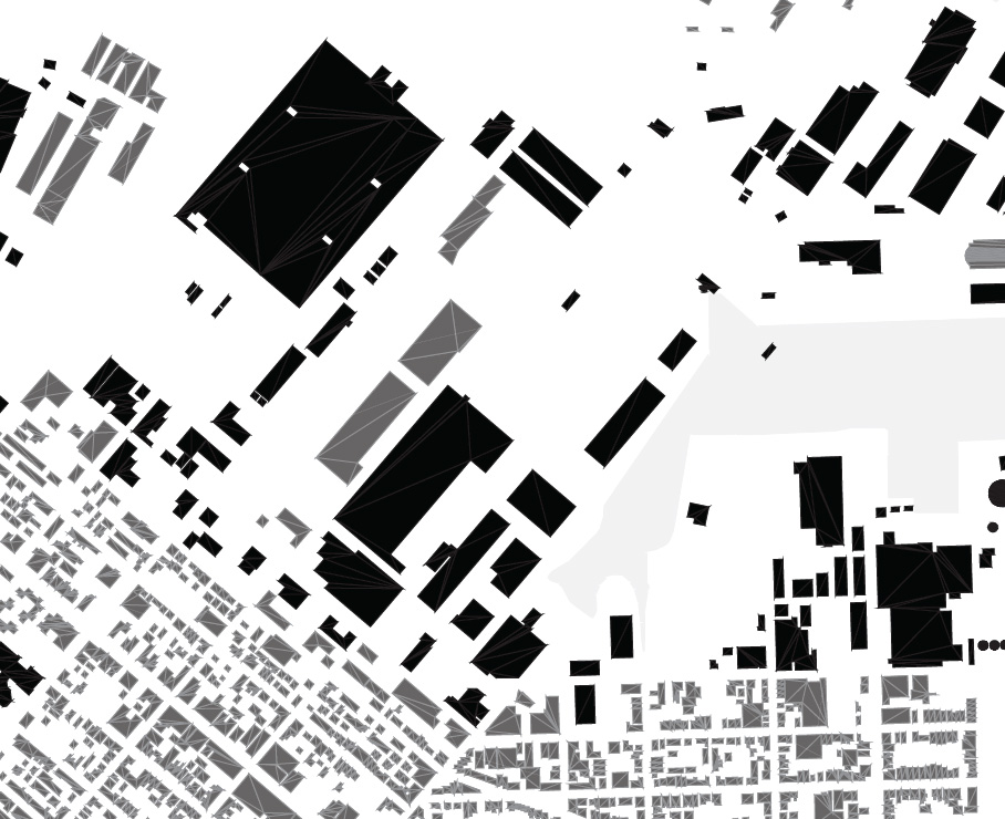
Please see the image below. When I export or print to pdf, the vertices of the polygons (shape file data) are visible, resulting in a poor quality final image. Is there a way to get these polygons to export to pdf without the vertices showing up? Obviously, I would prefer a clean, solid polygon hatch. Thanks in advance for any info.
6 REPLIES 6
Message 2 of 7
04-01-2012
11:32 PM
- Mark as New
- Bookmark
- Subscribe
- Mute
- Subscribe to RSS Feed
- Permalink
- Report
04-01-2012
11:32 PM
I guess you're talking about visible edges, not vertices...
As a workaround, you could plot to a DWF file, then from Autodesk Design Review you print that .DWF to .PDF (rasterizing all).

Message 3 of 7
04-02-2012
02:35 AM
- Mark as New
- Bookmark
- Subscribe
- Mute
- Subscribe to RSS Feed
- Permalink
- Report
04-02-2012
02:35 AM
which version of map and service packs, etc? what pdf plot setting are you trying? Are the vertices a seperate sdf than the polygons?
Message 4 of 7
04-02-2012
07:50 AM
- Mark as New
- Bookmark
- Subscribe
- Mute
- Subscribe to RSS Feed
- Permalink
- Report
04-02-2012
07:50 AM
Thanks for the reply.
I just installed Autodesk Map 3D 2011 and have not installed any service packs (unless those are included inthe latest install of 2011).
I have exported to pdf and plotted to pdf, both show the results previouly posted. I did not see an option to set the pdf export quality or compatibility, are those options in some other dialogue or options menu?
The polygons are a single shape file downloaded from Massachusetts GIS. On the screen in Map 3D, these edges are not visible.
Message 5 of 7
04-02-2012
07:54 AM
- Mark as New
- Bookmark
- Subscribe
- Mute
- Subscribe to RSS Feed
- Permalink
- Report
04-02-2012
07:54 AM
Thanks for your reply.
Yes, edges is probably the terms for them, I wasn't avtually sure what to call them.
The workaround you suggested does work, but I was hoping to keep the graphic as a pdf vector. I find that vector graphics just look better on the screen than rastorized images (this graphic will be for digital use). But, maybe that's just my perception.
Message 6 of 7
04-02-2012
07:59 AM
- Mark as New
- Bookmark
- Subscribe
- Mute
- Subscribe to RSS Feed
- Permalink
- Report
04-02-2012
07:59 AM
I have run across this same problem before on my own plots (Map3D 2010 all service packs) when plotting objects that are connected via FDO. Plotting to DWF first and then plotting from Design Review, per Antoniovinci's suggestion has sometimes worked for me, but not every time.
You may also want to try opening the PDF from various different PC's as well. One thing that I found with this problem is that some computers could open the PDF file and there were none of the lines, while other computers would open the same file and the lines would be there. I even tested to see if the problem was on the Adobe side by taking two different PC's, updating each to the most current version of Acrobat, and then opening the file. Even after that, however, one had the lines, the other did not.
Norm
*Edit*
Added two screenshots of one of my own PDF's. This is the same PDF file viewed on two different PC's with the same version of Acrobat used to open the file (file at same zoom level as well). One file has the lines through the parcels, the other does not.
GIS Specialist
BOXX Technologies APEXX 2 2402 Workstation
Intel Core i7-6700K @ 4.4 GHz
32 GB RAM / 500 GB SSD
NVIDIA Quadro M2000 Graphics
Windows 7 Pro 64 bit C3D 2017
BOXX Technologies APEXX 2 2402 Workstation
Intel Core i7-6700K @ 4.4 GHz
32 GB RAM / 500 GB SSD
NVIDIA Quadro M2000 Graphics
Windows 7 Pro 64 bit C3D 2017
Message 7 of 7
04-02-2012
08:45 AM
- Mark as New
- Bookmark
- Subscribe
- Mute
- Subscribe to RSS Feed
- Permalink
- Report
04-02-2012
08:45 AM
This is the same PDF file viewed on two different PC's with the same version of Acrobat used to open the file (file at same zoom level as well). One file has the lines through the parcels, the other does not.
Very interesting. If that is the case, maybe the problem isn't an issue with the Autodesk pdf export settings at all.
Reply
Topic Options
- Subscribe to RSS Feed
- Mark Topic as New
- Mark Topic as Read
- Float this Topic for Current User
- Bookmark
- Subscribe
- Printer Friendly Page

