Community
Civil 3D Forum
Welcome to Autodesk’s Civil 3D Forums. Share your knowledge, ask questions, and explore popular AutoCAD Civil 3D topics.
Turn on suggestions
Auto-suggest helps you quickly narrow down your search results by suggesting possible matches as you type.
Reply
Topic Options
- Subscribe to RSS Feed
- Mark Topic as New
- Mark Topic as Read
- Float this Topic for Current User
- Bookmark
- Subscribe
- Printer Friendly Page
Message 1 of 24
Anonymous
1745 Views, 23 Replies
01-18-2015
10:24 PM
- Mark as New
- Bookmark
- Subscribe
- Mute
- Subscribe to RSS Feed
- Permalink
- Report
01-18-2015
10:24 PM
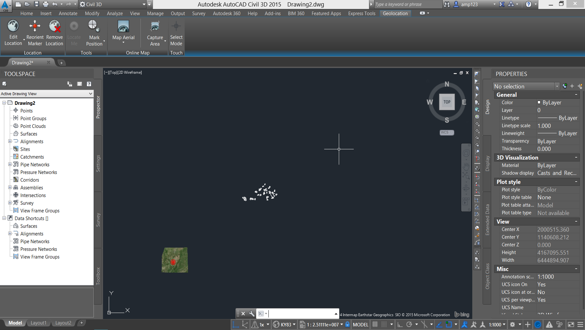
Earlier today, Bing maps was working just fine. Of course, after I somehow lose my progress, I went to redo all of my work to find that when I set the location, only part of the viewport is taken up by the satellite imagery. Also, my when I import shapefiles into the drawing, they do not line up. The coordinate system I set is KY83-N.
I've tried redoing to drawing from a fresh start multiple times with no avail.
AutoCAD Civil 3D 2015 SP2
Attached is what I'm looking at after trying REDRAWALL and REGENALL. Also, attached is the shapefile I'm trying to import.
Solved! Go to Solution.
Solved by sboon. Go to Solution.
23 REPLIES 23
Message 2 of 24
01-19-2015
01:56 AM
- Mark as New
- Bookmark
- Subscribe
- Mute
- Subscribe to RSS Feed
- Permalink
- Report
01-19-2015
01:56 AM
Amp,
Your Shapefile is in some version of Lats and Longs:

If I set the Shapefile to LL83, it shows up somewhere in Kentucky, but Live Maps doesn't cover your Shapes.

I dunno. Where did you get that Shapefile?
Dave
Dave Stoll
Las Vegas, Nevada
NVIDIA Quadro P5000 16GB
Windows 10 Pro 64 / Civil 3D 2024
Message 3 of 24
01-19-2015
02:38 AM
- Mark as New
- Bookmark
- Subscribe
- Mute
- Subscribe to RSS Feed
- Permalink
- Report
01-19-2015
02:38 AM
Hi Dave,
I found it on the Kentucky Geography Network by searching watershed. It's called, "Kentucky Division of Water - Priority Watersheds." I believe, based off of the past few hours of struggling... that KY83 only shows a very specific area of imagery. Therefore, trying a coordinate system like World Mercator would be ideal, since it encompasses the area that I need (Boyle County, KY), and then some . The unfortunate part, is that no other coordinate system (that I have tried so far) seems to work for the shapefile. By work, I just mean that the shapefile wont convert to the drawing's coordinate system.
By setting the shapfiles to LL83, do you mean you set the drawing's Coordinate System to LL83 or are you talking about the input coordinate system? Is it just me, or does the shapefile not convert to another coordinate system besides LL83?
Attached to this post is another shapefile that may make more sense and both its .prj file and that of the watershed shapefile you already have. Not sure if the .prj files will help, but I attached them anyway.
I really apreciate your help at this hour! I didn't expect to see a response till later this morning.
-Andres
Message 4 of 24
01-19-2015
03:48 AM
- Mark as New
- Bookmark
- Subscribe
- Mute
- Subscribe to RSS Feed
- Permalink
- Report
01-19-2015
03:48 AM
Andres,
I set the drawing to KY83-NF and FDO'ed in the Shapefile as LL84. The Shapefile is almost 400 miles wide, so I'm guessing that is the problem. I'll try your other files right now.
Dave
Dave Stoll
Las Vegas, Nevada
NVIDIA Quadro P5000 16GB
Windows 10 Pro 64 / Civil 3D 2024
Message 5 of 24
01-19-2015
04:02 AM
- Mark as New
- Bookmark
- Subscribe
- Mute
- Subscribe to RSS Feed
- Permalink
- Report
01-19-2015
04:02 AM
Andres,
I can see what County_Line_sps.shp looks like in QGIS, but I can't bring it into C3D:

Dave
Dave Stoll
Las Vegas, Nevada
NVIDIA Quadro P5000 16GB
Windows 10 Pro 64 / Civil 3D 2024
Message 6 of 24
01-19-2015
05:06 AM
- Mark as New
- Bookmark
- Subscribe
- Mute
- Subscribe to RSS Feed
- Permalink
- Report
01-19-2015
05:06 AM
Andres,
Finally got the County Lines into a drawing, but I can't get them to agree with the Watersheds SHP. Perplexing.

Dave
Dave Stoll
Las Vegas, Nevada
NVIDIA Quadro P5000 16GB
Windows 10 Pro 64 / Civil 3D 2024
Message 7 of 24
01-19-2015
06:29 AM
- Mark as New
- Bookmark
- Subscribe
- Mute
- Subscribe to RSS Feed
- Permalink
- Report
01-19-2015
06:29 AM
You might try setting up a drawing in a metric system and use map to convert it to survey feet. There could be an issue with the data not coverting from metric to feet.
Rick Jackson
Survey CAD Technician VI
Did you find this post helpful? Feel free to Like this post.
Did your question get successfully answered? Then click on the ACCEPT SOLUTION button.
Message 8 of 24
01-19-2015
07:41 AM
- Mark as New
- Bookmark
- Subscribe
- Mute
- Subscribe to RSS Feed
- Permalink
- Report
01-19-2015
07:41 AM
When you inported the shp file did you slect the correct coordinate system that the shp file is in?
With C3D or Map3D when you have objects in the dwg AND assigned a coordinate system to the dwg you do NOT need to set a location for Bing maps, that is for non civil/gis users only that know know coordinate systems.
Murph
Supporting the troops daily.

Supporting the troops daily.
Message 9 of 24
01-19-2015
08:10 AM
- Mark as New
- Bookmark
- Subscribe
- Mute
- Subscribe to RSS Feed
- Permalink
- Report
01-19-2015
08:10 AM
Murph,
The shapefiles came with .prj files that automatically include the input coordinates when using IMPORTMAP. At least, I think that's how it works. Either way, I did not change the input coordinates.
rl_Jackson,
I believe I tried that how you explained it and it did not work.
Dave,
I found a cool LINK showing the limited area that KY83(-S,-N) covers. From now on I'll try using KY83 single zone, but so far it only works with the county lines and watershed. It has not worked with two other shapefiles, one of which is attached to this post.
Thus far, only LL83 has had everything in the correct spot. The issue with LL83 is that Bing Maps does not allow me to capture the area
Message 10 of 24
01-19-2015
09:44 AM
- Mark as New
- Bookmark
- Subscribe
- Mute
- Subscribe to RSS Feed
- Permalink
- Report
01-19-2015
09:44 AM
This appears to be the same issue that I commented on in your other thread. Please post a screenshot of the transformation tab for your drawing.
Steve
Please use the Accept as Solution or Kudo buttons when appropriate
Steve
Expert Elite Alumnus
Expert Elite Alumnus

Message 12 of 24
01-19-2015
10:39 AM
- Mark as New
- Bookmark
- Subscribe
- Mute
- Subscribe to RSS Feed
- Permalink
- Report
01-19-2015
10:39 AM
When Map is used to set your coordinate system it inserts grid and local values into this tab. Even though you have the tab turned off Map still uses them to apply a translation to the data being imported. This bug is almost certainly the reason why your shapefiles are in the wrong location, and why the Bing map appears to be in the wrong spot.
Turn on the tab and make the local values match the grid ones. You can turn it back off again if you want, then try importing the shapes again.
Steve
Please use the Accept as Solution or Kudo buttons when appropriate
Steve
Expert Elite Alumnus
Expert Elite Alumnus
Message 14 of 24
Anonymous
in reply to:
Anonymous
01-19-2015
10:45 AM
- Mark as New
- Bookmark
- Subscribe
- Mute
- Subscribe to RSS Feed
- Permalink
- Report
01-19-2015
10:45 AM
This is what I have so far. Two shapefiles that are in the correct spot and two that are not. If I change the transformation tab, while possibly fixing the two that are off, wouldn't it also displace the ones that are correctly placed?

Message 15 of 24
01-19-2015
11:09 AM
- Mark as New
- Bookmark
- Subscribe
- Mute
- Subscribe to RSS Feed
- Permalink
- Report
01-19-2015
11:09 AM
Turn on the tab and make the local values match the grid ones. You can turn it back off again if you want, then try importing the shapes again.
Correction - make the grid values match local.

Copy the numbers from the red box and paste them into the blue box. If I am right you should see the Bing image suddenly shift to the correct location, and if you reimport the two bad shapefiles they should also come into the correct location.
I'm guessing that you imported the first two shapefiles then did something that caused the bug to kick in and screw up the transformation tab before importing the other files.
Steve
Please use the Accept as Solution or Kudo buttons when appropriate
Steve
Expert Elite Alumnus
Expert Elite Alumnus
Message 16 of 24
01-19-2015
11:51 AM
- Mark as New
- Bookmark
- Subscribe
- Mute
- Subscribe to RSS Feed
- Permalink
- Report
01-19-2015
11:51 AM
Wow...ok. That was a horrible experience to go through.
After doing as you suggested, Steve, it didn't necessarily work (Perhaps it's the way it works with this bug). However, once I re-imported the shapefiles, they all converged to one spot, but the imagery didn't follow until I reset the location. For a second, everything was as it should be, but then I zoomed and it the imagery changed to somewhere near Finland. After copying the local values to the grid values again (they were both zero), I was sent to some other part in the world. I essentially did another interation of the same process and then it finally worked. After capturing what I needed, I went back to check the transformation tab and the local values were 0, and the grid was another number.
Each time I was reseting the grid values and then setting the location.
Thanks everyone for the help.
-Andres
Message 17 of 24
01-19-2015
01:07 PM
- Mark as New
- Bookmark
- Subscribe
- Mute
- Subscribe to RSS Feed
- Permalink
- Report
01-19-2015
01:07 PM
That's the worst part; I'm fairly certain that I understand what the problem is, and I can usually reproduce it by comparing a metric UTM drawing to Google Earth but it's not 100% consistent. Sometimes it works the way it should.
Steve
Please use the Accept as Solution or Kudo buttons when appropriate
Steve
Expert Elite Alumnus
Expert Elite Alumnus
Message 18 of 24
01-19-2015
01:13 PM
- Mark as New
- Bookmark
- Subscribe
- Mute
- Subscribe to RSS Feed
- Permalink
- Report
01-19-2015
01:13 PM
Hey Steve,
Would you happen to know why AutoCAD is, "Unable to update Geomap Image?"
I'm trying to change to aerial imagery rather than hybrid, but it refuses.

Message 20 of 24
01-19-2015
04:02 PM
- Mark as New
- Bookmark
- Subscribe
- Mute
- Subscribe to RSS Feed
- Permalink
- Report
01-19-2015
04:02 PM
@Anonymous wrote:
Hey Steve,
Would you happen to know why AutoCAD is, "Unable to update Geomap Image?"
I'm trying to change to aerial imagery rather than hybrid, but it refuses.
Network hic-cup on your end, A360 or even on Bing maps end. Is that a captured area image or still a live image?
Murph
Supporting the troops daily.
Supporting the troops daily.
Reply
Topic Options
- Subscribe to RSS Feed
- Mark Topic as New
- Mark Topic as Read
- Float this Topic for Current User
- Bookmark
- Subscribe
- Printer Friendly Page

