Community
Civil 3D Forum
Welcome to Autodesk’s Civil 3D Forums. Share your knowledge, ask questions, and explore popular AutoCAD Civil 3D topics.
Turn on suggestions
Auto-suggest helps you quickly narrow down your search results by suggesting possible matches as you type.
Reply
Topic Options
- Subscribe to RSS Feed
- Mark Topic as New
- Mark Topic as Read
- Float this Topic for Current User
- Bookmark
- Subscribe
- Printer Friendly Page
- « Previous
-
- 1
- 2
- Next »
Message 1 of 29
01-21-2013
01:43 PM
- Mark as New
- Bookmark
- Subscribe
- Mute
- Subscribe to RSS Feed
- Permalink
- Report
01-21-2013
01:43 PM
Random shift in northing and easting
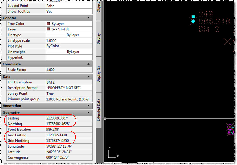
Civil 3D 2013, SP1, Windows 7, 64-bit - I've got a user who imports points into the survey database and RANDOMLY the points will be shifted on average 27 feet in the northing and 4 feet in the easting. She notices this becuase she'll check a point and see tht the northing and easting varies from the grid northing and easting (I've attached an image to view) She will then discard the drawing and begin a new one only to import the data and now it imports correctly. The behavior is completely random and it's happening on multiple projects. All the projects begin with the same template. All the settings (drawing settings and survey settings) have been set to US Survey Foot. It's weird because once the issue is noticed it can be fixed by simply beginning another drawing and re-importing the data, but it has happened on projects where she's already got pre-existing data. Any ideas on what may be causing this?
Thanks in advance,
Jason
Jason Porter
ASTI Civil Solutions Technical Advisor
www.asti.com
ASTI Civil Solutions Technical Advisor
www.asti.com
28 REPLIES 28
Message 21 of 29
01-30-2017
05:45 AM
- Mark as New
- Bookmark
- Subscribe
- Mute
- Subscribe to RSS Feed
- Permalink
- Report
01-30-2017
05:45 AM
Just a wild guess. Is there a transformation set up on the Transformation Tab in Drawing Settings? On the Import Points dialog box is "Do coordinate transformation if possible" checked? Is there any heading in the point file? What type of file is it? Would you be able to share a drawing and a point file for testing. If you don't want to share the files on the forum. Start a Service Request with Autodesk and have them take a look at it.
I don't blame you for being skittish. But I've been using the software for about a quarter century and the only time I've seen anything like this is with LDT points. If you don't solve it today you may want to try a Clean Install of Civil 3D. I did this last week to clear up some problems I was having.
Allen Jessup
CAD Manager - Designer
Did you find this post helpful? Feel free to Like this post.
Did your question get successfully answered? Then click on the ACCEPT SOLUTION button.
Message 22 of 29
01-30-2017
06:44 AM
- Mark as New
- Bookmark
- Subscribe
- Mute
- Subscribe to RSS Feed
- Permalink
- Report
01-30-2017
06:44 AM
Do other users access your drawings? Are the points locked before they get their hands on the drawings? Not knowing the level of user sophistication makes me think this could be user error. Points don't just roam around.
To make you feel less skittish, use the survey database.
Tim Corey
MicroCAD Training and Consulting, Inc.
Redding, CA
Autodesk Gold Reseller
New knowledge is the most valuable commodity on earth. -- Kurt Vonnegut
Message 23 of 29
01-04-2018
10:48 AM
- Mark as New
- Bookmark
- Subscribe
- Mute
- Subscribe to RSS Feed
- Permalink
- Report
01-04-2018
10:48 AM
I am experiencing the same shift here is my scenario:
My template is defaulted to Units: US Survey Feet and Coordinate System: None.
My project is in Michigan. (This is doesn't just apply to Michigan it is happening in all states that use international feet). I set my coordinate system to MI83-SIF through the Map pull down menu (...tools...assign global coordinate system). The units are automatically changed to international feet.
After I create the survey database, in the survey database setting I change the coordinate system to MI83-SIF. The units are automatically changed to international feet.
I then import the .csv point file. After selecting a point, I noticed in the Geometry section of the Properties there are two sets of coordinates (Easting/Northing and Grid Easting/Grid Northing) and they are not the same in fact they are 54 feet apart. I then imported the same point file through a regular import, not through the database. These points appeared 54 feet east of the survey database point import group, their coordinates being the Grid East/Grid Northing of the survey database point import group.
In an attempt to problem solve we have discovered if you set your coordinates system to none (through the drawing settings), reimport the points through the survey database they will land in the correct spot (the Grid location). I then change the coordinate system back to MI83-SIF and reimport the points through the survey data base and the points remain in the last imported location (the Grid location).
Why is the survey database doing this shift? Am I importing data correctly for international foot states? What is the right way to get my points in their correct spot without doing this back and forth changing of settings and multiple reimports?
FYI, if you do not set the coordinate system globally but you do for the survey database, your points will only be 27 feet off like the person who originally posted mentioned. For me this is not random. There is some sort of transformation error or setting or something.
Also, if you are continuing to test in the same drawing and same database it doesn't appear the shift will happen again with an import through the survey database.
Any help in identifying the correct process or a more reliable fix would be much appreciated.
Message 24 of 29
01-04-2018
10:56 AM
- Mark as New
- Bookmark
- Subscribe
- Mute
- Subscribe to RSS Feed
- Permalink
- Report
01-04-2018
10:56 AM
A couple of questions. Is the Survey file being imported collected in International Feet? There is usually a setting on the instrument or are these points being collected by GPS. Are the points reduced to Grid before or during import?
I'm not an expert. Hopefully @Pointdump may have some input.
Allen Jessup
CAD Manager - Designer
Did you find this post helpful? Feel free to Like this post.
Did your question get successfully answered? Then click on the ACCEPT SOLUTION button.
Message 25 of 29
01-04-2018
11:02 AM
- Mark as New
- Bookmark
- Subscribe
- Mute
- Subscribe to RSS Feed
- Permalink
- Report
01-04-2018
11:02 AM
The data was collected in international feet.
I am importing a csv file into CAD so that shouldn't matter. What I am observing is a transformation occurring when importing through the survey data base.
Message 26 of 29
01-04-2018
11:11 AM
- Mark as New
- Bookmark
- Subscribe
- Mute
- Subscribe to RSS Feed
- Permalink
- Report
01-04-2018
11:11 AM
I don't deal with the data until our Surveyor is done with it. Does the solution in this link help?
Allen Jessup
CAD Manager - Designer
Did you find this post helpful? Feel free to Like this post.
Did your question get successfully answered? Then click on the ACCEPT SOLUTION button.
Message 27 of 29
01-04-2018
11:12 AM
- Mark as New
- Bookmark
- Subscribe
- Mute
- Subscribe to RSS Feed
- Permalink
- Report
01-04-2018
11:12 AM
You have to have the units set to the same. Most likely the international units were set in the data collector and will remain so, even with new jobs until it is changed on project setup. There is quite a bit of difference in the two systems.
One other solution, if you aren't using grid coordinates, is to do an ascii text dump of the points and import them. In most programs, the units are not used. Just be aware that calculated points imported back into the data collector may be adjusted.
Hope this helps.
Lee
Message 28 of 29
01-04-2018
11:16 AM
- Mark as New
- Bookmark
- Subscribe
- Mute
- Subscribe to RSS Feed
- Permalink
- Report
01-04-2018
11:16 AM
Virginia,
Welcome to the Autodesk Forums.
In addition to Allen's questions, can you post a drawing and data?
Dave
Dave Stoll
Las Vegas, Nevada
NVIDIA Quadro P5000 16GB
Windows 10 Pro 64 / Civil 3D 2024
Message 29 of 29
01-04-2018
11:19 AM
- Mark as New
- Bookmark
- Subscribe
- Mute
- Subscribe to RSS Feed
- Permalink
- Report
01-04-2018
11:19 AM
This has nothing to do with the data collector or the point file. This is only occurring during an import through the survey database.
If I do a regular import, NOT through the survey database, there are no issues, the points land where they ought to be.
When importing through the survey database....Once the global coordinate system is set to a coordinate system with international feet and/or the survey database is also set to international feet, your data will shift 27 or 54 feet depending on if you set the coordinate system in one spot or both spots.
- « Previous
-
- 1
- 2
- Next »
Reply
Topic Options
- Subscribe to RSS Feed
- Mark Topic as New
- Mark Topic as Read
- Float this Topic for Current User
- Bookmark
- Subscribe
- Printer Friendly Page
- « Previous
-
- 1
- 2
- Next »

