Community
Civil 3D Forum
Welcome to Autodesk’s Civil 3D Forums. Share your knowledge, ask questions, and explore popular AutoCAD Civil 3D topics.
Turn on suggestions
Auto-suggest helps you quickly narrow down your search results by suggesting possible matches as you type.
Reply
Topic Options
- Subscribe to RSS Feed
- Mark Topic as New
- Mark Topic as Read
- Float this Topic for Current User
- Bookmark
- Subscribe
- Printer Friendly Page
Message 1 of 29
01-21-2013
01:43 PM
- Mark as New
- Bookmark
- Subscribe
- Mute
- Subscribe to RSS Feed
- Permalink
- Report
01-21-2013
01:43 PM
Random shift in northing and easting
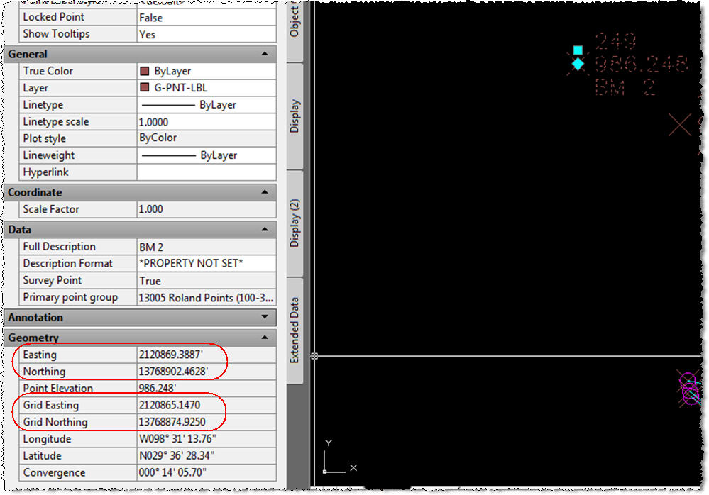
Civil 3D 2013, SP1, Windows 7, 64-bit - I've got a user who imports points into the survey database and RANDOMLY the points will be shifted on average 27 feet in the northing and 4 feet in the easting. She notices this becuase she'll check a point and see tht the northing and easting varies from the grid northing and easting (I've attached an image to view) She will then discard the drawing and begin a new one only to import the data and now it imports correctly. The behavior is completely random and it's happening on multiple projects. All the projects begin with the same template. All the settings (drawing settings and survey settings) have been set to US Survey Foot. It's weird because once the issue is noticed it can be fixed by simply beginning another drawing and re-importing the data, but it has happened on projects where she's already got pre-existing data. Any ideas on what may be causing this?
Thanks in advance,
Jason
Jason Porter
ASTI Civil Solutions Technical Advisor
www.asti.com
ASTI Civil Solutions Technical Advisor
www.asti.com
28 REPLIES 28
Message 2 of 29
01-21-2013
03:01 PM
- Mark as New
- Bookmark
- Subscribe
- Mute
- Subscribe to RSS Feed
- Permalink
- Report
01-21-2013
03:01 PM
Sounds like you are importing them with International Feet when it should be US Survey Feet. Right-click on your survey database and select Edit Survey Database Settings. Change the International Feet to US Survey Feet. You will have to re-import the points after you fix this.
Todd Rogers
Message 3 of 29
01-21-2013
04:31 PM
- Mark as New
- Bookmark
- Subscribe
- Mute
- Subscribe to RSS Feed
- Permalink
- Report
01-21-2013
04:31 PM
Check to be sure you have the same coordinate system selected, not just units.
Surveyor Lee
Message 4 of 29
01-22-2013
12:06 AM
- Mark as New
- Bookmark
- Subscribe
- Mute
- Subscribe to RSS Feed
- Permalink
- Report
01-22-2013
12:06 AM
Yes, I would check the coordinate system. Here in Australia, we used to use AGD66, but now using MGA94. Coordinates in the old system are offset by approximately 150m, east and north. This used to cause all manner of confusion until people got used to it. I'm sure the same has happened just about everywhere over the world at one time or another.
Civil3d user in Australia since 2012.
Message 5 of 29
01-28-2013
07:05 PM
- Mark as New
- Bookmark
- Subscribe
- Mute
- Subscribe to RSS Feed
- Permalink
- Report
01-28-2013
07:05 PM
I've verified all your suggestions in some of the past projects and current ones. All the settings are correct and in line with your suggestions. The weird thing. . .remember, this happens randomly. All the settings are the same throughout each project. So why does it randomly shift the coordinates? And why is it always the same (or similar) distances? Maybe it's something on our systems.
Thank you all for all your input.
Jason
Jason Porter
ASTI Civil Solutions Technical Advisor
www.asti.com
ASTI Civil Solutions Technical Advisor
www.asti.com
Message 6 of 29
01-29-2013
02:29 AM
- Mark as New
- Bookmark
- Subscribe
- Mute
- Subscribe to RSS Feed
- Permalink
- Report
01-29-2013
02:29 AM
I guess I'd start basic troubleshooting - is it only one file (or group of files?), is it only affecting one template? is it only one computer or all of them? etc. Is it only after a certain command (is it truely random)? Is the offset amount the same? what amount is it offset by (anything familiar?)? etc. etc. Is the offset permanent or does it fix itself later?
Are you able to post the file?
Interestingly, I had a similar issue occur on one drawing just today - I haven't had time to investigate yet, but I noticed that some drawn objects were offset in relation to the underlying Bing imagery. It might be the imagery georeferencing has been altered, or I accidently moved stuff, or maybe something more sinister like you're experiencing 😞
I'll have to do some checking on my file.
Civil3d user in Australia since 2012.
Message 7 of 29
01-29-2013
05:17 AM
- Mark as New
- Bookmark
- Subscribe
- Mute
- Subscribe to RSS Feed
- Permalink
- Report
01-29-2013
05:17 AM
If you insert a drawing with the shifted points in to a new one created from your template and reimport the points, overwriting the old ones. Does that bring the points in properly?
What is the original source of the points? Were they ever converted from LDT points?
Allen Jessup
CAD Manager - Designer
Did you find this post helpful? Feel free to Like this post.
Did your question get successfully answered? Then click on the ACCEPT SOLUTION button.
Message 8 of 29
01-29-2013
07:33 AM
- Mark as New
- Bookmark
- Subscribe
- Mute
- Subscribe to RSS Feed
- Permalink
- Report
01-29-2013
07:33 AM
Yes, I've started basic trouble shooting. Here are the answers to your questions. . .
- We notice the issue when we begin a drawing and then dump the survey (ASCII) points into the drawing. We check a few points and notice the points have shifted. We can kill that drawing and begin a new drawing (with the exact same template) and then the issue is gone.
- We've begun a new drawing with the Imperial NCS template (out of the box) and with a couple of others. Again it's random, so sometimes it works and sometimes it doesn't, and it doesn't matter which template we use.
- The offset amount is averaging 27 feet in the northing and 4 feet in the easting. Both are always in the positive shift direction.
- The offset is permanant and doesn't ever resolve itself.
- It's so random that we can be working in a drawing where we've inserted points in the past and have been working on it for some time. Then we get new points and import them only to see them shift.
- The points were not originally LDT points. These are newly gathered points from our surveyors. They are your typical PNEZD comma dilimitted ASCII point files.
I will try the suggestion of taking the shifted points and inserting them into a new one to see if that works. Now I just have to wait until the issue happens again. We're now logging events:
- When it happens
- Time of day it happens
- Whose system it happens on
- If we disconnect from the network will it happen
Thanks for all the input. If I find anything that resolves this I'll repost.
Good day to all,
Jason
Jason Porter
ASTI Civil Solutions Technical Advisor
www.asti.com
ASTI Civil Solutions Technical Advisor
www.asti.com
Message 10 of 29
01-29-2013
03:59 PM
- Mark as New
- Bookmark
- Subscribe
- Mute
- Subscribe to RSS Feed
- Permalink
- Report
01-29-2013
03:59 PM
Have you verified that he surveyors gathered the point coordinates on the same coordinate system? If they gathered them in one system and converted them to another, you could be getting some that are not on the same system.
Surveyor Lee
Message 11 of 29
01-29-2013
05:36 PM
- Mark as New
- Bookmark
- Subscribe
- Mute
- Subscribe to RSS Feed
- Permalink
- Report
01-29-2013
05:36 PM
Yes, we've verified that the surveyor's are gathering the data in the same coordinate system. I forgot about the BASE command. I'll try it. But why would it suddenly change if I'm using the same template and the same computer everytime?
Jason
Jason Porter
ASTI Civil Solutions Technical Advisor
www.asti.com
ASTI Civil Solutions Technical Advisor
www.asti.com
Message 12 of 29
01-30-2013
10:27 AM
- Mark as New
- Bookmark
- Subscribe
- Mute
- Subscribe to RSS Feed
- Permalink
- Report
01-30-2013
10:27 AM
@PorterCAD wrote:But why would it suddenly change if I'm using the same template and the same computer everytime?
One thing that comes to mind for me would be some errant program/script that runs at startup. Maybe something prevents it from running in some cases (so there are SOME times that it doesn't change the setting). Or the intention could be to change it and then change it back--something could be preventing the change back.
When you're troubleshooting something odd like this, you have to totally forget about any notions like "it can't be that--so I don't need to check it". Check EVERYTHING even remotely related to the topic until you can reproduce the issue under the narrowest circumstances. Once you've done that, you should be able to find the cause.
Don Ireland
Engineering Design Technician![]()
If a reply solves your issue, please remember to click on "Accept as Solution". This will help other users looking to solve a similar issue. Thank you.
Please do not send a PM asking for assistance. That's what the forums are for. This allows everyone to benefit from the question asked and the answers given.
Message 13 of 29
01-27-2017
03:09 PM
- Mark as New
- Bookmark
- Subscribe
- Mute
- Subscribe to RSS Feed
- Permalink
- Report
01-27-2017
03:09 PM
Has a solution been found. I am having the same issue random points shifted, some of which where imported and some created in c3d. They shifted in 4' north and 1' west.
All i did was open drawing add a few points, make an upload and print maps. About 40 of 200 points where shifted. Completely at random.
All i did was open drawing add a few points, make an upload and print maps. About 40 of 200 points where shifted. Completely at random.
Message 14 of 29
01-27-2017
03:14 PM
- Mark as New
- Bookmark
- Subscribe
- Mute
- Subscribe to RSS Feed
- Permalink
- Report
01-27-2017
03:14 PM
I have not had that issue again. The distance you are describing sounds like a part of the data is international foot and part is us foot
Lee Howell
843-819-7496
Sent from my iPhone
Lee Howell
843-819-7496
Sent from my iPhone
Message 15 of 29
01-27-2017
03:27 PM
- Mark as New
- Bookmark
- Subscribe
- Mute
- Subscribe to RSS Feed
- Permalink
- Report
01-27-2017
03:27 PM
It does but it is at random, points I created and points imported. Last month the drawing was fine this time they shifted. Example: points 1-10 created by me in cad, when I opened drawing points 2 45 and 9 would be shifted. Funny thing is when I went to close the drawing it crashed.
Message 16 of 29
01-28-2017
07:07 AM
- Mark as New
- Bookmark
- Subscribe
- Mute
- Subscribe to RSS Feed
- Permalink
- Report
01-28-2017
07:07 AM
Are the 40 shifted points originally to the drawing or some of the recently inserted.
Allen Jessup
CAD Manager - Designer
Did you find this post helpful? Feel free to Like this post.
Did your question get successfully answered? Then click on the ACCEPT SOLUTION button.
Message 17 of 29
01-29-2017
04:10 AM
- Mark as New
- Bookmark
- Subscribe
- Mute
- Subscribe to RSS Feed
- Permalink
- Report
01-29-2017
04:10 AM
heres my suggestion
next time it happens
dont close c3d just start a new job and reimport and see if the 2nd file is also off
next time it happens
dont close c3d just start a new job and reimport and see if the 2nd file is also off
Message 18 of 29
01-29-2017
09:34 AM
- Mark as New
- Bookmark
- Subscribe
- Mute
- Subscribe to RSS Feed
- Permalink
- Report
01-29-2017
09:34 AM
Jason, I would bet dollars to dimes this is going to be caused by the international feet vs. us survey feet issue, as stated by @ToddRogers-WPM and @SurveyorLee. I see this issue very often and aligning the survey database and drawing settings to US Survey Feet fixes the issue.
As a test, scale the points by 0.999998000004, using 0,0 as the base point. If not, if they got farther apart, then scale by 1.000002.
If one of those two factors fixes the points, then this proves that Todd and Lee are right.
Tim Corey
MicroCAD Training and Consulting, Inc.
Redding, CA
Autodesk Gold Reseller
New knowledge is the most valuable commodity on earth. -- Kurt Vonnegut
Message 19 of 29
01-30-2017
03:24 AM
- Mark as New
- Bookmark
- Subscribe
- Mute
- Subscribe to RSS Feed
- Permalink
- Report
01-30-2017
03:24 AM
Sorry for chiming in so late here. I'm traveling right now.
Yes, I agree, the shift in value does sound like an international vs. US survey feet issue. However, in my testing with the client I was working with on this topic we used the same template every time and I verified the settings were in US survey feet. In one instance the points came in correctly and in the next they all shifted.
I'm not saying that this is the solution, but in this one case we had reset the user's Windows profile and the the issue appears to have disappeared. Prior to that we repaired the software and did a clean reinstall. The reason I cannot definitively state the it was the Windows profile is because the user tested a lot of other settings prior to resetting the profile.
I agree with @caddie99, next time it happens don't close the software and immediately test in an new drawing.
Also, @AllenJessup brings up a good point. . .is the shift happening to all points in the drawing or just newly inserted points?
@ron.lang, you stated that the software crashed when closing the drawing. Do you have any/all service packs installed for your version of Civil 3D? Have you tried running a repair on the software? Have you tried resetting the software back to default settings? Have you tried using the standard Civil 3D NCS template to test?
Jason Porter
ASTI Civil Solutions Technical Advisor
www.asti.com
ASTI Civil Solutions Technical Advisor
www.asti.com
Message 20 of 29
01-30-2017
05:27 AM
- Mark as New
- Bookmark
- Subscribe
- Mute
- Subscribe to RSS Feed
- Permalink
- Report
01-30-2017
05:27 AM
It's no a us foot vs international ft issue. At least not one caused by user settings. The points shifted were RANDOM. Some of which I created with the software and some imported at time of drawing creation about 6 months ago.
Again only a few of each not in any recognized order.
I am familiar with the us vs int ft shift and this is not it.
I am pretty sure all sp are installed and software is up to date, I will check today.
@AllenJessup. The shift occured to points already in the drawing, not the newly created.
Thanks guys for your input,
As a surveyor I am now very skiddish with this software for point stakeout.
Reply
Topic Options
- Subscribe to RSS Feed
- Mark Topic as New
- Mark Topic as Read
- Float this Topic for Current User
- Bookmark
- Subscribe
- Printer Friendly Page

