Community
Civil 3D Forum
Welcome to Autodesk’s Civil 3D Forums. Share your knowledge, ask questions, and explore popular AutoCAD Civil 3D topics.
Turn on suggestions
Auto-suggest helps you quickly narrow down your search results by suggesting possible matches as you type.
Reply
Topic Options
- Subscribe to RSS Feed
- Mark Topic as New
- Mark Topic as Read
- Float this Topic for Current User
- Bookmark
- Subscribe
- Printer Friendly Page
Message 1 of 8
03-28-2008
10:02 AM
- Mark as New
- Bookmark
- Subscribe
- Mute
- Subscribe to RSS Feed
- Permalink
- Report
03-28-2008
10:02 AM
Paralell Automatic Labels
Hey everyone,
As you see in the picture I have a subdivision that follows a curving road, and therefore all the lot lines also follow the road. This is unfortunate, as I have been creating label styles 1 by 1 for left, center, right, for every angle of line. Is there a way to get your label to go parallel with the line automatically?
What I am thinking of is with structures, there is that circular grip that rotates the structure, is there something similar to this with labels? or must i keep grinding away making the labels one by one in their separate degree intervals.
Right now I have 33 label styles.... and I am not even 1/4 of the way done.
Any help would be greatly appreciated.
Thank you
7 REPLIES 7
Message 2 of 8
03-28-2008
10:36 AM
- Mark as New
- Bookmark
- Subscribe
- Mute
- Subscribe to RSS Feed
- Permalink
- Report
03-28-2008
10:36 AM
Picture?
--
Matt Kolberg
Global CADD Systems
www.gcscorp.ca
wrote in message news:5888625@discussion.autodesk.com...
Hey everyone,
As you see in the picture I have a subdivision that follows a curving road,
and therefore all the lot lines also follow the road. This is unfortunate,
as I have been creating label styles 1 by 1 for left, center, right, for
every angle of line. Is there a way to get your label to go parallel with
the line automatically?
What I am thinking of is with structures, there is that circular grip that
rotates the structure, is there something similar to this with labels? or
must i keep grinding away making the labels one by one in their separate
degree intervals.
Right now I have 33 label styles.... and I am not even 1/4 of the way done.
Any help would be greatly appreciated.
Thank you
--
Matt Kolberg
Global CADD Systems
www.gcscorp.ca
Hey everyone,
As you see in the picture I have a subdivision that follows a curving road,
and therefore all the lot lines also follow the road. This is unfortunate,
as I have been creating label styles 1 by 1 for left, center, right, for
every angle of line. Is there a way to get your label to go parallel with
the line automatically?
What I am thinking of is with structures, there is that circular grip that
rotates the structure, is there something similar to this with labels? or
must i keep grinding away making the labels one by one in their separate
degree intervals.
Right now I have 33 label styles.... and I am not even 1/4 of the way done.
Any help would be greatly appreciated.
Thank you
Message 3 of 8
03-28-2008
10:39 AM
- Mark as New
- Bookmark
- Subscribe
- Mute
- Subscribe to RSS Feed
- Permalink
- Report
03-28-2008
10:39 AM
Since there is no image I'm going to take a stav at it. I assume you're
talking about the distacen / bearing labels for parcel segment? Thos can
most certainly automatically line up with the parcel segment it's labeling.
In the General tab of the label style dialog you'll need to set the
orientation to Object. I hope you didn't spend too much time cerating those
33 styles.
--
Matt Kolberg
Global CADD Systems
www.gcscorp.ca
wrote in message news:5888625@discussion.autodesk.com...
Hey everyone,
As you see in the picture I have a subdivision that follows a curving road,
and therefore all the lot lines also follow the road. This is unfortunate,
as I have been creating label styles 1 by 1 for left, center, right, for
every angle of line. Is there a way to get your label to go parallel with
the line automatically?
What I am thinking of is with structures, there is that circular grip that
rotates the structure, is there something similar to this with labels? or
must i keep grinding away making the labels one by one in their separate
degree intervals.
Right now I have 33 label styles.... and I am not even 1/4 of the way done.
Any help would be greatly appreciated.
Thank you
talking about the distacen / bearing labels for parcel segment? Thos can
most certainly automatically line up with the parcel segment it's labeling.
In the General tab of the label style dialog you'll need to set the
orientation to Object. I hope you didn't spend too much time cerating those
33 styles.
--
Matt Kolberg
Global CADD Systems
www.gcscorp.ca
Hey everyone,
As you see in the picture I have a subdivision that follows a curving road,
and therefore all the lot lines also follow the road. This is unfortunate,
as I have been creating label styles 1 by 1 for left, center, right, for
every angle of line. Is there a way to get your label to go parallel with
the line automatically?
What I am thinking of is with structures, there is that circular grip that
rotates the structure, is there something similar to this with labels? or
must i keep grinding away making the labels one by one in their separate
degree intervals.
Right now I have 33 label styles.... and I am not even 1/4 of the way done.
Any help would be greatly appreciated.
Thank you
Message 4 of 8
03-28-2008
12:12 PM
- Mark as New
- Bookmark
- Subscribe
- Mute
- Subscribe to RSS Feed
- Permalink
- Report
Message 5 of 8
03-28-2008
03:39 PM
- Mark as New
- Bookmark
- Subscribe
- Mute
- Subscribe to RSS Feed
- Permalink
- Report
03-28-2008
03:39 PM
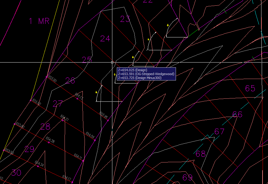
Ok I see what's going on. Those are spot elevations. I can think of two
things, two of which require 2009 unfortunately.
1. add points with labels styles that look like that. you will be able to
rotate them easily with the new rotation grip. you can do this with 2008,
but without the grip.
2. line label styles in 2009 have an optino to snap the label to the end of
the feature line segment AND have it label the elevation of that end point.
3. this one does NOT require 2009. add feature line labels with the
elevation (they will be added to the center of the line) and then just drag
them to the end points.
--
Matt Kolberg
Global CADD Systems
www.gcscorp.ca
wrote in message news:5888866@discussion.autodesk.com...
I am an idiot.... sorry.. here is the pic
things, two of which require 2009 unfortunately.
1. add points with labels styles that look like that. you will be able to
rotate them easily with the new rotation grip. you can do this with 2008,
but without the grip.
2. line label styles in 2009 have an optino to snap the label to the end of
the feature line segment AND have it label the elevation of that end point.
3. this one does NOT require 2009. add feature line labels with the
elevation (they will be added to the center of the line) and then just drag
them to the end points.
--
Matt Kolberg
Global CADD Systems
www.gcscorp.ca
I am an idiot.... sorry.. here is the pic
Message 6 of 8
Anonymous
in reply to:
Anonymous
02-02-2013
09:47 AM
- Mark as New
- Bookmark
- Subscribe
- Mute
- Subscribe to RSS Feed
- Permalink
- Report
02-02-2013
09:47 AM
Hi, I apologize for bringing this topic up again, I'm using the 2013 CIVIL 3D version and I'm having the exact same issue as the poster of this thread. I've looked all around but cannot seem to find many topics relating to this.
Is there a thread that you may know of that might have instructions of how to spot label elevations that are parallel to the lot lines?
Message 7 of 8
02-02-2013
01:17 PM
- Mark as New
- Bookmark
- Subscribe
- Mute
- Subscribe to RSS Feed
- Permalink
- Report
Message 8 of 8
02-03-2013
10:30 PM
- Mark as New
- Bookmark
- Subscribe
- Mute
- Subscribe to RSS Feed
- Permalink
- Report
02-03-2013
10:30 PM
How nice it would be if we could reference GIS attributes and C3D object data in fields. It would make available all the Annotation scale capabilities of Autocad and in other ways simplify the whole annotation workflow.
Neil Wilson (a.k.a. neilw)
AEC Collection/C3D 2024, LDT 2004, Power Civil v8i SS1
WIN 10 64 PRO
http://www.sec-landmgt.com
AEC Collection/C3D 2024, LDT 2004, Power Civil v8i SS1
WIN 10 64 PRO
http://www.sec-landmgt.com
Reply
Topic Options
- Subscribe to RSS Feed
- Mark Topic as New
- Mark Topic as Read
- Float this Topic for Current User
- Bookmark
- Subscribe
- Printer Friendly Page
Forums Links
Can't find what you're looking for? Ask the community or share your knowledge.
Post to forums

