- Subscribe to RSS Feed
- Mark Topic as New
- Mark Topic as Read
- Float this Topic for Current User
- Bookmark
- Subscribe
- Printer Friendly Page
- Mark as New
- Bookmark
- Subscribe
- Mute
- Subscribe to RSS Feed
- Permalink
- Report
When I create a grid from our OSIP DEM files the contours come in as a block. I usually do 1' and 5' contours. I would like to break these so that when I select a 1' contour it will show up individually with elevation data still attached. If you select one now, it selects the entire grid. If you explode it, you lose the grid file. Is there a way to do this or will a just have to label the contours so I know where I am at?
Solved! Go to Solution.
Solved by AllenJessup. Go to Solution.
Solved by wfberry. Go to Solution.
- Mark as New
- Bookmark
- Subscribe
- Mute
- Subscribe to RSS Feed
- Permalink
- Report
I do not have a Dem contour file opened at the present but:
1. Can you not hover over the contour and get the elevation?
or
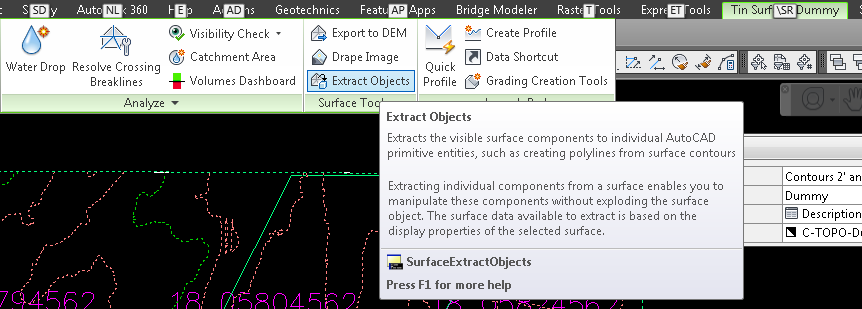
2. Use the Utilities in the Surface menu and select EXTRACT OBJECTS From SURFACE. You can pull a polyline right out.
Bill
- Mark as New
- Bookmark
- Subscribe
- Mute
- Subscribe to RSS Feed
- Permalink
- Report
By "Block" do you mean a Civil 3D Tin Surface? If so, you can extract contours from Surface. As soon as my Computer comes back to life.
Allen Jessup![]()
Allen Jessup
CAD Manager - Designer
Did you find this post helpful? Feel free to Like this post.
Did your question get successfully answered? Then click on the ACCEPT SOLUTION button.
- Mark as New
- Bookmark
- Subscribe
- Mute
- Subscribe to RSS Feed
- Permalink
- Report
When I hover over the grid, I get an elevation at that point but I cannot select individual contours. I guess I'm just looking to break them into individual line. It may not even be necessary but for some reason I want it that way.
- Mark as New
- Bookmark
- Subscribe
- Mute
- Subscribe to RSS Feed
- Permalink
- Report
Thank you Allen, that is exactly what I wanted to do!! You will be seeing me more frequently as I am new to civil3d. I used land development for years and then I have been on Bentley Microstation for the past 5 so this will take some adjustment. BTW this was a grid from DEM not a TIN surface but it did not seem to matter.
- Mark as New
- Bookmark
- Subscribe
- Mute
- Subscribe to RSS Feed
- Permalink
- Report
@tpuck2687 wrote:
I am new to civil3d.
Welcome to the club. One thing you're going to need to know is that all of the dynamic Civil 3D objects are a single object. They do behave much like blocks but aren't blocks. In the example of a Surface. How it's displayed depends on the Surface Style that is assigned to it. You might change it from a Style that displays contours to a style that displays triangles and points.. That doesn't change the Surface object. Just how it is displayed.
Allen
Allen Jessup
CAD Manager - Designer
Did you find this post helpful? Feel free to Like this post.
Did your question get successfully answered? Then click on the ACCEPT SOLUTION button.
- Mark as New
- Bookmark
- Subscribe
- Mute
- Subscribe to RSS Feed
- Permalink
- Report
That definetly clears some things up and I thank you for your help. Are there any posts or tutorials you could point me toward for watershed or catchment creations?
- Mark as New
- Bookmark
- Subscribe
- Mute
- Subscribe to RSS Feed
- Permalink
- Report
AEC Collection/C3D 2024, LDT 2004, Power Civil v8i SS1
WIN 10 64 PRO
http://www.sec-landmgt.com
- Subscribe to RSS Feed
- Mark Topic as New
- Mark Topic as Read
- Float this Topic for Current User
- Bookmark
- Subscribe
- Printer Friendly Page


