Community
- Forums Home
- >
- Civil 3D Community
- >
- Civil 3D Forum
- >
- Re: Default Survey Database Settings - Distance Units
Civil 3D Forum
Welcome to Autodesk’s Civil 3D Forums. Share your knowledge, ask questions, and explore popular AutoCAD Civil 3D topics.
Turn on suggestions
Auto-suggest helps you quickly narrow down your search results by suggesting possible matches as you type.
Reply
Topic Options
- Subscribe to RSS Feed
- Mark Topic as New
- Mark Topic as Read
- Float this Topic for Current User
- Bookmark
- Subscribe
- Printer Friendly Page
Message 1 of 8
Anonymous
757 Views, 7 Replies
06-11-2009
09:50 AM
- Mark as New
- Bookmark
- Subscribe
- Mute
- Subscribe to RSS Feed
- Permalink
- Report
06-11-2009
09:50 AM
Default Survey Database Settings - Distance Units
2010 - Where could I specify the default Distance Units to US Foot in the Survey Database Settings?
Currently, when I create a new Survey Database the default distance unit is set to International Foot. I then need to edit the Survey Database Settings to change the distance unit. I would like to edit the default distance unit.
Thanks!
Brent
Currently, when I create a new Survey Database the default distance unit is set to International Foot. I then need to edit the Survey Database Settings to change the distance unit. I would like to edit the default distance unit.
Thanks!
Brent
7 REPLIES 7
Message 2 of 8
06-18-2009
09:55 AM
- Mark as New
- Bookmark
- Subscribe
- Mute
- Subscribe to RSS Feed
- Permalink
- Report
06-18-2009
09:55 AM
Don't know if it is the case in 2010, but in 2009 you can set your settings then save the file. You can then set that file as the default file in the Survey User Settings area under "Survey Database Settings".
Hope that helps. I don't know how to modify the default file but this worked great.
Tony Edited by: tleggieri on Jun 18, 2009 12:55 PM
Hope that helps. I don't know how to modify the default file but this worked great.
Tony Edited by: tleggieri on Jun 18, 2009 12:55 PM
Message 3 of 8
Anonymous
in reply to:
Anonymous
06-18-2009
11:56 AM
- Mark as New
- Bookmark
- Subscribe
- Mute
- Subscribe to RSS Feed
- Permalink
- Report
06-18-2009
11:56 AM
Tony,
Thank you for your reply.
I basically do not want to have to edit the survey database settings for each Database that I create.
I performed a test (C3D 2010):
1) Create new drawing with Imperial template and perform a save
2) Verify Drawing settings are set to US Survey Foot and assign State Plane Coordinate system
3) Click Survey Tab and rt-click Survey Databases to create New Local Database called Survey_test
4) Rt-click Survey_test to edit Survey Database Settings - Here I notice that it is set to International Foot (Annoying)
5) Change the value to US Foot and Export to a file called Survey_test.sdb_set
6) Create new Survey Database called Survey_test-2
7) Rt-click Survey_test-2 to edit Survey Database Settings - Here I notice that it is set to International Foot (Annoying)
8) Rt-click Survey_test-2 to edit Survey Database Settings - Import .sdb_set file and it is still International Foot
hmm...maybe I needed to select okay, re-edit survey database settings and then export
8) Rt-click Survey_test-2 and to edit Survey Database Settings - Change the value to US Foot and select OK
10) Reaccess the Survey Database Settings by rt-click on Survey_test-2 and export to a file called Survey_test-2.sdb_set
11) Create new Survey Database called Survey_test-3
12) Rt-click Survey_test-3 to edit Survey DAtabase Settings - Still International Foot
13) Import new .sdb_set file and it is still International Foot
Does anyone know where C3D is getting this setting from? Can I change the default distance unit to be US Foot for any new Survey Database?
Message 4 of 8
06-18-2009
12:28 PM
- Mark as New
- Bookmark
- Subscribe
- Mute
- Subscribe to RSS Feed
- Permalink
- Report
06-18-2009
12:28 PM
I think you've got it up to step 5
> 1) Create new drawing with Imperial template and perform a save
> 2) Verify Drawing settings are set to US Survey Foot and assign State Plane Coordinate system
> 3) Click Survey Tab and rt-click Survey Databases to create New Local Database called Survey_test
> 4) Rt-click Survey_test to edit Survey Database Settings - Here I notice that it is set to International Foot (Annoying)
> 5) Change the value to US Foot and Export to a file called Survey_test.sdb_set
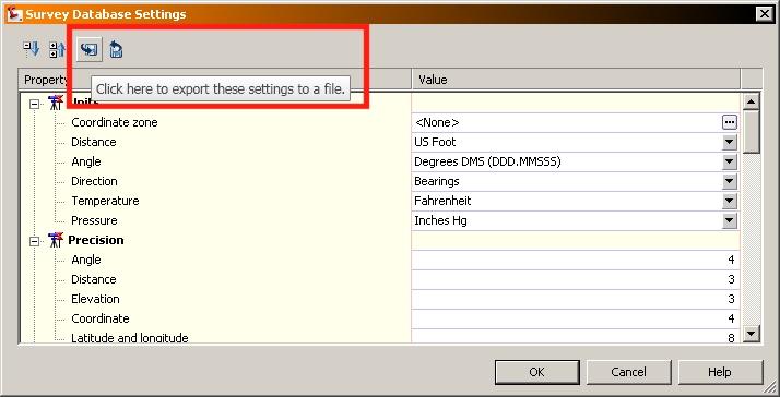
At this point, you just need to set that exported file as the new default. Do this by going to the SURVEY USER SETTINGS button at the top of the toolspace and then set the path to wherever you exported the file. The next field down is a drop down that you should now be able to set to your new exported file.
See the attached image. I wish I knew where the default was pulling from, but I have a feeling it is buried in an XML file somewhere...help is not much help on the survey stuff, at least not in 2009. Edited by: tleggieri on Jun 18, 2009 3:29 PM
> 1) Create new drawing with Imperial template and perform a save
> 2) Verify Drawing settings are set to US Survey Foot and assign State Plane Coordinate system
> 3) Click Survey Tab and rt-click Survey Databases to create New Local Database called Survey_test
> 4) Rt-click Survey_test to edit Survey Database Settings - Here I notice that it is set to International Foot (Annoying)
> 5) Change the value to US Foot and Export to a file called Survey_test.sdb_set
At this point, you just need to set that exported file as the new default. Do this by going to the SURVEY USER SETTINGS button at the top of the toolspace and then set the path to wherever you exported the file. The next field down is a drop down that you should now be able to set to your new exported file.
See the attached image. I wish I knew where the default was pulling from, but I have a feeling it is buried in an XML file somewhere...help is not much help on the survey stuff, at least not in 2009. Edited by: tleggieri on Jun 18, 2009 3:29 PM
Message 5 of 8
Anonymous
in reply to:
Anonymous
06-18-2009
12:39 PM
- Mark as New
- Bookmark
- Subscribe
- Mute
- Subscribe to RSS Feed
- Permalink
- Report
06-18-2009
12:39 PM
Tony,
I am so dense sometimes...thank you. That is what I have been overlooking...bad habit of continually going to the SETTINGS tab of toolspace for Settings. Survey is an exception...it has its OWN settings.
Thank you!
Brent
I am so dense sometimes...thank you. That is what I have been overlooking...bad habit of continually going to the SETTINGS tab of toolspace for Settings. Survey is an exception...it has its OWN settings.
Thank you!
Brent
Message 6 of 8
06-18-2009
12:45 PM
- Mark as New
- Bookmark
- Subscribe
- Mute
- Subscribe to RSS Feed
- Permalink
- Report
06-18-2009
12:45 PM
You are very welcome. I am setting all of our settings now and it seems the survey portion was written on another planet. Totally different work flow to set/change things. Oh well...
By the way, if you are used to entering angles as DD.MMSSSS, make sure to set that in the AMBIENT SETTINGS. We found out the hard way that the default is DECIMAL.
But, on the plus side, we found the Radial Stakeout report works great!!
By the way, if you are used to entering angles as DD.MMSSSS, make sure to set that in the AMBIENT SETTINGS. We found out the hard way that the default is DECIMAL.
But, on the plus side, we found the Radial Stakeout report works great!!
Message 7 of 8
08-09-2009
03:09 PM
- Mark as New
- Bookmark
- Subscribe
- Mute
- Subscribe to RSS Feed
- Permalink
- Report
08-09-2009
03:09 PM
once you get your design corridor, how do you generate radial stakeout reports for the new design? thanks, Mike
Message 8 of 8
08-10-2009
06:42 AM
- Mark as New
- Bookmark
- Subscribe
- Mute
- Subscribe to RSS Feed
- Permalink
- Report
08-10-2009
06:42 AM
Under the CORRIDOR drop down, under utilities is "Create COGO points from corridor..."
Go through the dialog and tell it what link you wish to create points on.
Then you can run the radial report with whatever occupied point and backsight point/distance you wish.
Note that the corridor utility will put points at every sample station point on the link you choose.
Go through the dialog and tell it what link you wish to create points on.
Then you can run the radial report with whatever occupied point and backsight point/distance you wish.
Note that the corridor utility will put points at every sample station point on the link you choose.
Reply
Topic Options
- Subscribe to RSS Feed
- Mark Topic as New
- Mark Topic as Read
- Float this Topic for Current User
- Bookmark
- Subscribe
- Printer Friendly Page

