Community
- Forums Home
- >
- Civil 3D Community
- >
- Civil 3D Forum
- >
- Re: can we create contours from JPEG file in Civil 3D?
Civil 3D Forum
Welcome to Autodesk’s Civil 3D Forums. Share your knowledge, ask questions, and explore popular AutoCAD Civil 3D topics.
Turn on suggestions
Auto-suggest helps you quickly narrow down your search results by suggesting possible matches as you type.
Reply
Topic Options
- Subscribe to RSS Feed
- Mark Topic as New
- Mark Topic as Read
- Float this Topic for Current User
- Bookmark
- Subscribe
- Printer Friendly Page
Message 1 of 11
12-04-2012
03:19 AM
- Mark as New
- Bookmark
- Subscribe
- Mute
- Subscribe to RSS Feed
- Permalink
- Report
12-04-2012
03:19 AM
I've an old countour map (hard copy drawn ages ago) which now I want to digitize.
I've scanned this map (can be saved in JPEG, PDF etc format) however I don't know if there is an easy way to create contour lines from this JPEG image.
really appreciate inputs in this regard.
Solved! Go to Solution.
Solved by Joe-Bouza. Go to Solution.
Solved by AllenJessup. Go to Solution.
10 REPLIES 10
Message 2 of 11
12-04-2012
04:09 AM
- Mark as New
- Bookmark
- Subscribe
- Mute
- Subscribe to RSS Feed
- Permalink
- Report
12-04-2012
04:09 AM
The easiest way is to vectorize 'em automatically by means of the free Wintopo, then in Autocad you assign elevation to the resulting contours.

Message 3 of 11
12-04-2012
10:29 AM
- Mark as New
- Bookmark
- Subscribe
- Mute
- Subscribe to RSS Feed
- Permalink
- Report
12-04-2012
10:29 AM
Quite frankly, if you are not planning on doing this very often, just scale it (properly) and trace with polylines. You will be waaay ahead.
Bill
Message 4 of 11
12-04-2012
02:42 PM
- Mark as New
- Bookmark
- Subscribe
- Mute
- Subscribe to RSS Feed
- Permalink
- Report
12-04-2012
02:42 PM
Hi Bill,
Saw your quotes on the *EE* video by Brian Kling. Way to go! Excellent and congrats <G>
Your Name
Did you find this post helpful? Feel free to Like this post.
Did your question get successfully answered? Then click on the ACCEPT SOLUTION button.
Message 5 of 11
12-04-2012
03:27 PM
- Mark as New
- Bookmark
- Subscribe
- Mute
- Subscribe to RSS Feed
- Permalink
- Report
12-04-2012
03:27 PM
Raster Design has a contour follower in the vectorization tools. It will create polylines with elevations as a best fit to the raster pixels. It's not perfect but probably better than manual tracing. See the Raster Design help file for the contour follower tool.
Neil Wilson (a.k.a. neilw)
AEC Collection/C3D 2024, LDT 2004, Power Civil v8i SS1
WIN 10 64 PRO
http://www.sec-landmgt.com
AEC Collection/C3D 2024, LDT 2004, Power Civil v8i SS1
WIN 10 64 PRO
http://www.sec-landmgt.com
Message 6 of 11
12-05-2012
07:08 AM
- Mark as New
- Bookmark
- Subscribe
- Mute
- Subscribe to RSS Feed
- Permalink
- Report
12-05-2012
07:08 AM
I'd agree that tracing is a good option for the occasional project of this nature. As mentioned Raster Design and other programs will do this type of work. However they usually need human intervention unless you have a very clear image. So between the cost and the fact that it would probably not be a automatic as you hope. Tracing on screen is a good way to go.
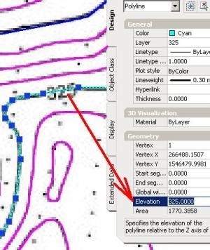
If you do trace on screen. You can save some time by setting the Elevation variable to the contour elevation before you start to draw each polyline. Remember to use 2D polylines as elevation.
Allen
Allen Jessup
CAD Manager - Designer
Did you find this post helpful? Feel free to Like this post.
Did your question get successfully answered? Then click on the ACCEPT SOLUTION button.
Message 7 of 11
12-05-2012
07:20 AM
- Mark as New
- Bookmark
- Subscribe
- Mute
- Subscribe to RSS Feed
- Permalink
- Report
12-05-2012
07:20 AM
If you have a clean image there are some PDF to DWG converters with free trials like THIS ONE. you still have to set the elevation.
You can clean things up preyy easily in raster before convert.
Your Name
Did you find this post helpful? Feel free to Like this post.
Did your question get successfully answered? Then click on the ACCEPT SOLUTION button.
Message 8 of 11
12-05-2012
08:55 PM
- Mark as New
- Bookmark
- Subscribe
- Mute
- Subscribe to RSS Feed
- Permalink
- Report
12-05-2012
08:55 PM
Thak you all for your replies.
Yes, this is one off project where I need to do this and requirement for accuracy probably dictates the method to be adopted...so I guess doing it manually is the best fit.
thanks again.
Message 9 of 11
12-06-2012
01:46 AM
- Mark as New
- Bookmark
- Subscribe
- Mute
- Subscribe to RSS Feed
- Permalink
- Report
12-06-2012
01:46 AM
Kinga, please pay attention to the mentioned freeware Wintopo, 'cause it's well-suited for "line art" like raster contours.
Finally it may convert the result not only to vector DXF but also to shapefile, to which you can add geometric fields as area or length with opensource software, e.g. Qgis.
Message 10 of 11
12-06-2012
04:48 AM
- Mark as New
- Bookmark
- Subscribe
- Mute
- Subscribe to RSS Feed
- Permalink
- Report
12-06-2012
04:48 AM
I've used Wintopo and it does a reasonable job although I imagine the quality of the output will depend on the quality of the jpeg used
neilyj (No connection with Autodesk other than using the products in the real world)
Did you find this post helpful? Feel free to Like this post.
Did your question get successfully answered? Then click on the ACCEPT SOLUTION button.
AEC Collection 2024 UKIE (mainly Civil 3D UKIE and IW)
Win 11 Pro x64, 1Tb Primary SSD, 1Tb Secondary SSD
64Gb RAM Intel(R) Xeon(R) W-11855M CPU @ 3.2GHz
NVIDIA RTX A5000 16Gb, Dual 27" Monitor, Dell Inspiron 7760
Message 11 of 11
04-24-2013
10:20 AM
- Mark as New
- Bookmark
- Subscribe
- Mute
- Subscribe to RSS Feed
- Permalink
- Report
Reply
Topic Options
- Subscribe to RSS Feed
- Mark Topic as New
- Mark Topic as Read
- Float this Topic for Current User
- Bookmark
- Subscribe
- Printer Friendly Page

