Community
- Forums Home
- >
- Civil 3D Community
- >
- Civil 3D Forum
- >
- Re: Bing Maps - Incorrect position of Mapping 2015 English
Civil 3D Forum
Welcome to Autodesk’s Civil 3D Forums. Share your knowledge, ask questions, and explore popular AutoCAD Civil 3D topics.
Turn on suggestions
Auto-suggest helps you quickly narrow down your search results by suggesting possible matches as you type.
Reply
Topic Options
- Subscribe to RSS Feed
- Mark Topic as New
- Mark Topic as Read
- Float this Topic for Current User
- Bookmark
- Subscribe
- Printer Friendly Page
Message 1 of 7
01-26-2015
05:21 AM
- Mark as New
- Bookmark
- Subscribe
- Mute
- Subscribe to RSS Feed
- Permalink
- Report
01-26-2015
05:21 AM
Ever since I have updated the Geolocation patch I recieve incorrect locations for bing mapping data. "AcGeoLocationUI.arx is 20.0.210.3 "
Aparently the OSGB Grid now extends into France? I have checked the Lat Long it produces in the Map coordinate box and the Bing translation which are listed as the same.
I select the map position and accept the corrdinates given by geolocation for insertion. The file coordinate system is set to OSGB National Grid, Bing is set the same with GMT(0:000) time zone, meters.
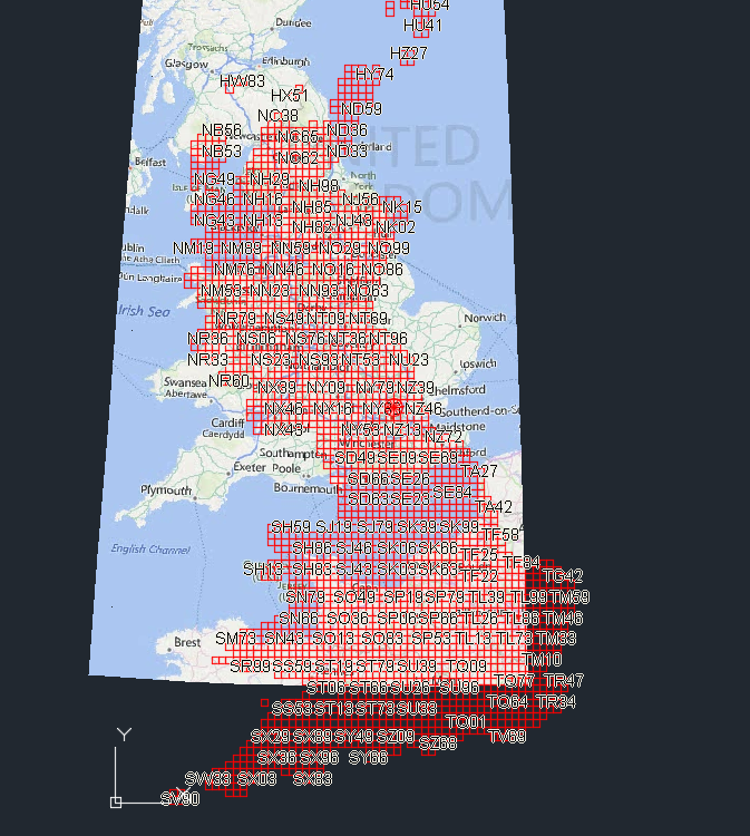
When overlayed with the OSGB Grids from Map shp file there is a definate shift in the bing mapping location. See image.
Any Ideas?
Mike Evans
Civil3D 2022 English
Windows 7 Professional 64-bit
Intel(R) Core(TM) i7-3820 CPU @ 3.60GHz (8 CPUs), ~4.0GHz With 32768MB RAM, AMD FirePro V4900, Dedicated Memory: 984 MB, Shared Memory: 814 MB

Civil3D 2022 English
Windows 7 Professional 64-bit
Intel(R) Core(TM) i7-3820 CPU @ 3.60GHz (8 CPUs), ~4.0GHz With 32768MB RAM, AMD FirePro V4900, Dedicated Memory: 984 MB, Shared Memory: 814 MB
Solved! Go to Solution.
Solved by Murph_Map. Go to Solution.
6 REPLIES 6
Message 2 of 7
01-26-2015
06:55 AM
- Mark as New
- Bookmark
- Subscribe
- Mute
- Subscribe to RSS Feed
- Permalink
- Report
01-26-2015
06:55 AM
Mike,
From Steve Boon @sboon, in <<<This Thread>>>:
"Map is supposed to be ignoring the Transformation tab, but as noted in the bug it seems to apply the screwed up values when it places the Geolocation marker and imports the Bing mapping. Resetting the values in the Transformation tab so that the Grid values match the Local ones, and setting the Grid rotation to zero appears to solve these problems."
This happens even if your Transformation Tab is disabled:

Dave
Dave Stoll
Las Vegas, Nevada
NVIDIA Quadro P5000 16GB
Windows 10 Pro 64 / Civil 3D 2024
Message 3 of 7
01-26-2015
08:51 AM
- Mark as New
- Bookmark
- Subscribe
- Mute
- Subscribe to RSS Feed
- Permalink
- Report
01-26-2015
08:51 AM
Oh that explains it Thanks. Seems slightly useless at the moment then unless you already know the exact location of a site in the same coordinates. I assume you need to be exact in picking the same point on the ground and also in maps which I expect to be almost impossible.
I clicked point and guessed and it is closer to the truth but still an epic fail.
Mike Evans
Civil3D 2022 English
Windows 7 Professional 64-bit
Intel(R) Core(TM) i7-3820 CPU @ 3.60GHz (8 CPUs), ~4.0GHz With 32768MB RAM, AMD FirePro V4900, Dedicated Memory: 984 MB, Shared Memory: 814 MB
Civil3D 2022 English
Windows 7 Professional 64-bit
Intel(R) Core(TM) i7-3820 CPU @ 3.60GHz (8 CPUs), ~4.0GHz With 32768MB RAM, AMD FirePro V4900, Dedicated Memory: 984 MB, Shared Memory: 814 MB
Message 4 of 7
01-26-2015
11:41 AM
- Mark as New
- Bookmark
- Subscribe
- Mute
- Subscribe to RSS Feed
- Permalink
- Report
01-26-2015
11:41 AM
Mike,
"I assume you need to be exact in picking the same point on the ground and also in maps which I expect to be almost impossible."
No, Local and Grid just need to be the same. Use whatever is already in the Local Northings and Eastings, copy and paste that into the Grid Northings and Eastings. And don't forget to set the Grid Rotation Angle to Zero.
Dave
Dave Stoll
Las Vegas, Nevada
NVIDIA Quadro P5000 16GB
Windows 10 Pro 64 / Civil 3D 2024
Message 5 of 7
01-27-2015
08:57 AM
- Mark as New
- Bookmark
- Subscribe
- Mute
- Subscribe to RSS Feed
- Permalink
- Report
01-27-2015
08:57 AM
I tried this and failed.
I got the mapping using the info provided then tried correcting the tranformation tab and re obtained the mapping. This didn't help.
However I seemed to stumble on a simple fix.
I removed the geo position altogether and allowed the removal of the coordinate system.
Re set the coordinate system and checked the Tranformation tab (all values for local and plane matched) Trnaformation set to "ON".
Got the map and it was spot on. Don't know why this worked, I think something to do with the Geographic location.
So to clarify before getting mapping:
Remove / Reset the Geographic Location.
Add Coordinate Spacial Zone
Ensure transformation grids match on tab and transformation is ON.
Get the mapping data.
Thanks for the assistance on this one, has been bugging me for a while. However can others try the above and confirm I am correct please then I'll close the post.
Mike
Mike Evans
Civil3D 2022 English
Windows 7 Professional 64-bit
Intel(R) Core(TM) i7-3820 CPU @ 3.60GHz (8 CPUs), ~4.0GHz With 32768MB RAM, AMD FirePro V4900, Dedicated Memory: 984 MB, Shared Memory: 814 MB
Civil3D 2022 English
Windows 7 Professional 64-bit
Intel(R) Core(TM) i7-3820 CPU @ 3.60GHz (8 CPUs), ~4.0GHz With 32768MB RAM, AMD FirePro V4900, Dedicated Memory: 984 MB, Shared Memory: 814 MB
Message 6 of 7
01-27-2015
03:39 PM
- Mark as New
- Bookmark
- Subscribe
- Mute
- Subscribe to RSS Feed
- Permalink
- Report
01-27-2015
03:39 PM
@mikeevans wrote:
I tried this and failed.
I got the mapping using the info provided then tried correcting the tranformation tab and re obtained the mapping. This didn't help.
However I seemed to stumble on a simple fix.
I removed the geo position altogether and allowed the removal of the coordinate system.
Re set the coordinate system and checked the Tranformation tab (all values for local and plane matched) Trnaformation set to "ON".
Got the map and it was spot on. Don't know why this worked, I think something to do with the Geographic location.
......................
Mike
I never use the geolocation to pick a location and the coordinate system. As long as there is a coordinate system assigned to the dwg and there is a least one entity in the dwg (in the location I need and georeferanced) I just use the geomap command to add the maps/image.
Murph
Supporting the troops daily.

Supporting the troops daily.
Message 7 of 7
01-28-2015
03:42 AM
- Mark as New
- Bookmark
- Subscribe
- Mute
- Subscribe to RSS Feed
- Permalink
- Report
01-28-2015
03:42 AM
Hit the nail on the Head Murph.
I often use the Mapping tool to locate the site on the Ordinance Survey Grid so I can then focus on the area and import Mapping data Aerial Imagery (by OSGrid Tile) and Geospacial features located on & around my site. Often our surveys are not projected to OSGrid coordinates for some stange reason, Probably Cost as some recently have been a small building. So I know not where they are in the world and would have to back work to locate them.
However, I have tried this using a query on place names, nearest town to get a Geo-referanced entity then focus on that area. Then running the geomap command works correctly.
Thanks. Kudos to you Sir.
Mike
Mike Evans
Civil3D 2022 English
Windows 7 Professional 64-bit
Intel(R) Core(TM) i7-3820 CPU @ 3.60GHz (8 CPUs), ~4.0GHz With 32768MB RAM, AMD FirePro V4900, Dedicated Memory: 984 MB, Shared Memory: 814 MB
Civil3D 2022 English
Windows 7 Professional 64-bit
Intel(R) Core(TM) i7-3820 CPU @ 3.60GHz (8 CPUs), ~4.0GHz With 32768MB RAM, AMD FirePro V4900, Dedicated Memory: 984 MB, Shared Memory: 814 MB
Reply
Topic Options
- Subscribe to RSS Feed
- Mark Topic as New
- Mark Topic as Read
- Float this Topic for Current User
- Bookmark
- Subscribe
- Printer Friendly Page

