Community
Civil 3D Forum
Welcome to Autodesk’s Civil 3D Forums. Share your knowledge, ask questions, and explore popular AutoCAD Civil 3D topics.
Turn on suggestions
Auto-suggest helps you quickly narrow down your search results by suggesting possible matches as you type.
Reply
Topic Options
- Subscribe to RSS Feed
- Mark Topic as New
- Mark Topic as Read
- Float this Topic for Current User
- Bookmark
- Subscribe
- Printer Friendly Page
Message 1 of 21
11-01-2012
09:02 AM
- Mark as New
- Bookmark
- Subscribe
- Mute
- Subscribe to RSS Feed
- Permalink
- Report
11-01-2012
09:02 AM
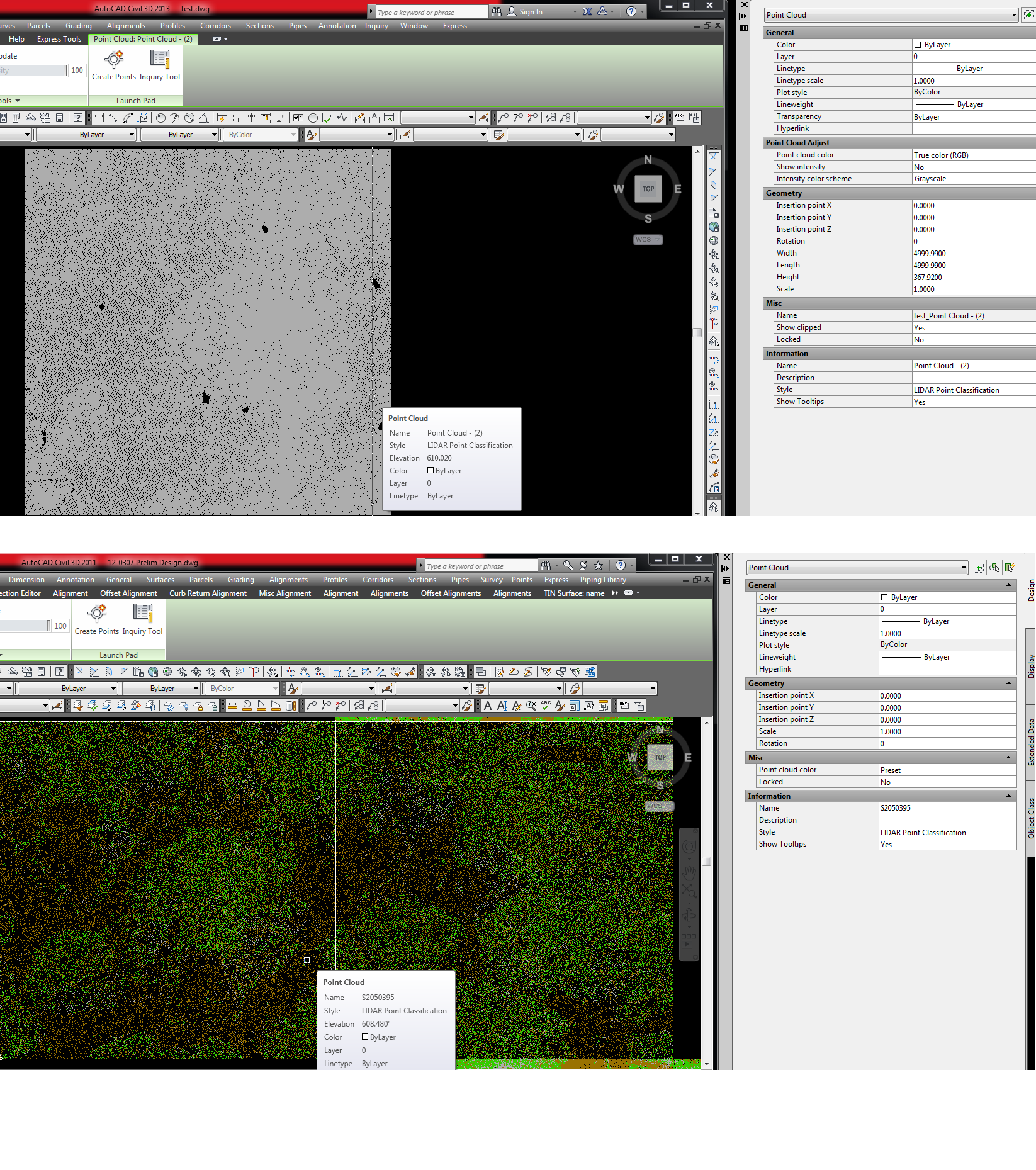
See pic. Top pic is 2013 point cloud properties. bottom pic is 2011 point cloud properties. 2013 has a new 'point cloud adjust' option in properties.
Both drawings have same 'Lidar Classification' Style, but 2013 is all gray. I tried changing some fields inside the properties for 2013 under the point cloud adjust to no avail.
Can anyone provide any feedback on why this is like this and what I need to do to see the different colors for the different classifications.
Thanks, Shawn
Solved! Go to Solution.
Solved by sfore. Go to Solution.
20 REPLIES 20
Message 2 of 21
11-01-2012
09:20 AM
- Mark as New
- Bookmark
- Subscribe
- Mute
- Subscribe to RSS Feed
- Permalink
- Report
11-01-2012
09:20 AM
Havent messed with point clouds, but by looking at the images, 2013 intensity color scheme is set to grayscale. Might have something to do with it.
Steve Goessling
Land Consultants
Civil3D 2015
Windows 7, 64 bit
Intel i7 2600 @ 3.40Ghz
16 GB RAM
Nvidia Quadro 600
Land Consultants
Civil3D 2015
Windows 7, 64 bit
Intel i7 2600 @ 3.40Ghz
16 GB RAM
Nvidia Quadro 600
Message 3 of 21
11-01-2012
10:39 AM
- Mark as New
- Bookmark
- Subscribe
- Mute
- Subscribe to RSS Feed
- Permalink
- Report
11-01-2012
10:39 AM
I believe you may have found a bug. I was not able to get a point cloud to display via classification like I could in previous versions. In fact, if you go through the tutorial HERE it doesn't work. If you are able to, you should submit this up to Autodesk.
Message 4 of 21
11-01-2012
10:57 AM
- Mark as New
- Bookmark
- Subscribe
- Mute
- Subscribe to RSS Feed
- Permalink
- Report
11-01-2012
10:57 AM
Under the 'Point Cloud Adjust' , the intesity color scheme is the only setting you can change. The other 2 settings can be changed, but it doesn't change anything visually.
Message 5 of 21
11-01-2012
11:01 AM
- Mark as New
- Bookmark
- Subscribe
- Mute
- Subscribe to RSS Feed
- Permalink
- Report
11-01-2012
11:01 AM
Its so aggravating dealing with bugs within C3D. I can't understand why styles that worked perfectly fine in one version gets whacked in another version. I waste so much time trying to get to the root of the problem because often times, I think its something I did or forgeot to check or setup.
How do I go about submitting this Point Cloud woe to Autodesk?
Message 6 of 21
11-01-2012
01:50 PM
- Mark as New
- Bookmark
- Subscribe
- Mute
- Subscribe to RSS Feed
- Permalink
- Report
11-01-2012
01:50 PM
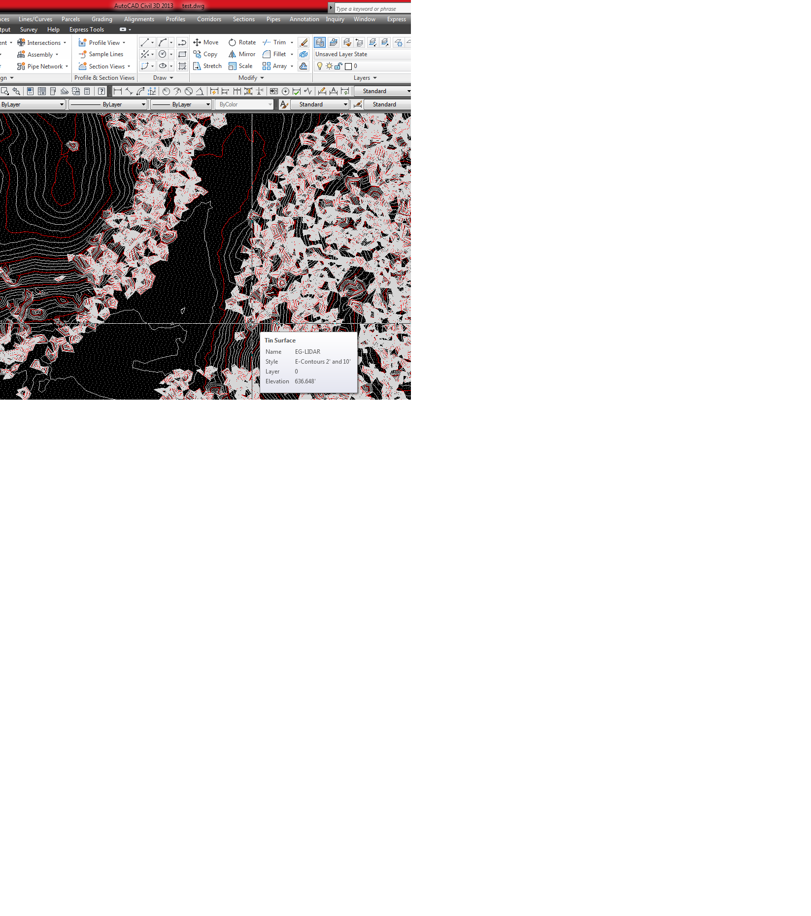
See pic. It's even worse than previously thought. Adding point cloud to surface is also broke.
Pic on left is contours in 2013. Pic on right is contours in 2011. The same point cloud tile was used. This needs fixed ASAP. We're implementing 2013 now and we do a lot of surface elevation analysis using lidar data for waterline jobs.
Can Autodesk comment on this, please anyone from Autodesk.
Message 7 of 21
11-08-2012
08:31 AM
- Mark as New
- Bookmark
- Subscribe
- Mute
- Subscribe to RSS Feed
- Permalink
- Report
11-08-2012
08:31 AM
The difference in surfaces you are seeing is most likely due to the Level of Detail. I believe this is "on" by default in 2013, but if you run LEVELOFDETAILOFF the surfaces should appear the same as they were in 2011.
Hope this helps!
Seth Hall
Product Owner
Model Builder
Message 8 of 21
11-08-2012
09:33 AM
- Mark as New
- Bookmark
- Subscribe
- Mute
- Subscribe to RSS Feed
- Permalink
- Report
11-08-2012
09:33 AM
See new pic after settings was changed in c3d2013. I changed setting. Contour appeared a little different but the issues are still there. The lidar classification style is still displaying the points all in gray and the contours are whacked just like the picture shows and this is with all lidar classifications off except ground.
In c3d2011, its fine and you could generate a surface with all the classifications on and it contoured houses, tree canopy's etc., then if you turned off all classifications except ground classification and rebuild the surface, the contours adjusted and appeared just fine. This is not the case in 2013, so something is still broke. the leveloffdetail did not fix the issues. Please stay in touch with this matter.
Shawn
Message 10 of 21
11-15-2012
05:05 PM
- Mark as New
- Bookmark
- Subscribe
- Mute
- Subscribe to RSS Feed
- Permalink
- Report
11-15-2012
05:05 PM
@SethHall wrote:The difference in surfaces you are seeing is most likely due to the Level of Detail. I believe this is "on" by default in 2013, but if you run LEVELOFDETAILOFF the surfaces should appear the same as they were in 2011.
Hope this helps!
Seth,
This has nothing to do with level of detail. The problem is with the style. It no longer will use the classification of the points in the style so all points come into the drawing as unclassified (even though in previous versions this worked just fine). Because of this, all points are then added to the surface resulting in a basically useless surface. I want a surface of the ground shots and not the tops of trees and utiltity poles and buildings and cars and...
If you want to discuss it with me, I can explain. Give me a call or shoot me an e-mail.
Message 11 of 21
11-16-2012
05:50 AM
- Mark as New
- Bookmark
- Subscribe
- Mute
- Subscribe to RSS Feed
- Permalink
- Report
11-16-2012
05:50 AM
Hi Brian and Shawn-
I apologize as I should have been more clear. The issue stated in the first post is a spearate issue from the second one stated in post #6 of this thread. The PNG files provided by Shawn illustrate a surface difference that is caused by LEVELOFDETAIL, I confirmed this on my machine. The first post issue with the colors of the style, you are correct, that is a known issue that Development is looking into.
Again I apologize for the confusion.
Have a great weekend!!
Seth Hall
Product Owner
Model Builder
Message 12 of 21
11-16-2012
07:14 AM
- Mark as New
- Bookmark
- Subscribe
- Mute
- Subscribe to RSS Feed
- Permalink
- Report
11-16-2012
07:14 AM
Seth, I just want to be clear. Both issues still remain. See pic in post 8. I understand the 'level of detail' now, and contours did adjust, but that didn't fix the issue of surface creation from 'Ground' only Classification. Brian's post clearly states this too. The classifications are no longer recognized.
I look forward to a fix for both issues.
Thanks, Shawn
Message 13 of 21
11-16-2012
07:25 AM
- Mark as New
- Bookmark
- Subscribe
- Mute
- Subscribe to RSS Feed
- Permalink
- Report
11-16-2012
07:25 AM
Hi Shawn-
So this is what I tested:
In 2011 I took the LAS file you sent me, created the ISD, then created the surface from all the points in the ISD and did not specify ground only.
in 2013 I repeated the same exact steps and compared the results, they were exactly the same. I did this to rule out any possible surface creation issue as the description on post #6 eluded to.
So back to the original style issue, the fact that they are all the same color and the classifications seem to be incorrect compared to 2013 is causing the surface creation issue as a byproduct. Are you still getting an incorrect surface creation when you build the surface from all the points?
Seth Hall
Product Owner
Model Builder
Message 14 of 21
11-16-2012
07:56 AM
- Mark as New
- Bookmark
- Subscribe
- Mute
- Subscribe to RSS Feed
- Permalink
- Report
11-16-2012
07:56 AM
Seems to be confusion with this matter. 2011 is fine. 2013 in NOT. See comparison below.
Turn off all point classification EXCEPT ground in 2011 and right click the surface and rebuild. The contours are nice and clean. Turn back on all lidar classifications, right click the surface and rebuild and you'll see abnormal contours from tree canopy, houses and such. All point classification colors are being recognized just fine.
Turn off all point classification EXCEPT ground in 2013 and right click the surface and rebuild. The contours are abnormal. Turn back on all lidar classifications, right click the surface and rebuild and the contours are still abnormal. Its the same either way. The classifications in 2013 are not being recognized in color or surface creation when classifications are checked on or off. Thus, giving us a useless surface to do any type of surface analysis.
Message 15 of 21
11-16-2012
08:56 AM
- Mark as New
- Bookmark
- Subscribe
- Mute
- Subscribe to RSS Feed
- Permalink
- Report
11-16-2012
08:56 AM
I suppose the current work around would be to create the surface in 2012 and then data reference it into your 2013 drawings, assuming of course you have access to the 2012 version of Civil 3D.
Message 16 of 21
12-17-2012
07:14 PM
- Mark as New
- Bookmark
- Subscribe
- Mute
- Subscribe to RSS Feed
- Permalink
- Report
12-17-2012
07:14 PM
Pretty terrible work around though.
Basically no point having point clouds in Civil 3D 2013 if you can't use the classifications to filter out ground points in las files.
Surprised this wasnt fixed as part of service pack 1!!
Regards
Civil 3D 2025 / Infraworks 2025
Win 10 -DELL Precision Notebook 7680
Want FREE TOOLS! Come get my free tools for civil 3d at website below!
https://ceethreedee.com/ceethreedee-tools
Win 10 -DELL Precision Notebook 7680
Want FREE TOOLS! Come get my free tools for civil 3d at website below!
https://ceethreedee.com/ceethreedee-tools
Message 17 of 21
12-18-2012
08:31 PM
- Mark as New
- Bookmark
- Subscribe
- Mute
- Subscribe to RSS Feed
- Permalink
- Report
12-18-2012
08:31 PM
@bkanthergolder wrote:Pretty terrible work around though.
Basically no point having point clouds in Civil 3D 2013 if you can't use the classifications to filter out ground points in las files.
Surprised this wasnt fixed as part of service pack 1!!
Regards
There are other point cloud files other then .las but I agree, if you are using classified .las files, they are pretty useless in Civil 3D 2013. Perhaps Autodesk has something up their sleeve. We can always hope.
Message 18 of 21
03-20-2013
04:30 PM
- Mark as New
- Bookmark
- Subscribe
- Mute
- Subscribe to RSS Feed
- Permalink
- Report
03-20-2013
04:30 PM
Any word on if/when Autodesk is fixing the Point Cloud issue in 2013? I just tried again with service pack 1 installed and issue remains. Classifications aren't recognized and surface is still whacked with only 'Ground' Classification toggled.
The only thing I know to do at this time is generate my surface in 2011, export Surface landxml, then import it in 2013.
Hopefully Autodesk will provide some news.
Shawn
Message 19 of 21
06-24-2013
07:03 AM
- Mark as New
- Bookmark
- Subscribe
- Mute
- Subscribe to RSS Feed
- Permalink
- Report
06-24-2013
07:03 AM
I"ve encountered the same issue. Does anyone know if this has been fixed yet? I'm running all the latest Service Packs to date and classification is not working thus leaving us no way to filter out just ground shots. I suspect that since this worked in 2011, I bet it worked in 2012 as well. I'm thinking it has to do with the big API changes in 2013 Civil3D as to why the classification is not working.
Steve
Steve Hill, Civil Designer / .NET Developer / AutoCAD and AutoCAD Civil 3D Certified Professional
Did you find this post helpful? Feel free to Like this post.
Did your question get successfully answered? Then click on the ACCEPT SOLUTION button.
http://redtransitconsultants.com/
Autodesk Exchange Store
Twitter | LinkedIn | YouTube
Message 20 of 21
08-15-2013
08:49 AM
- Mark as New
- Bookmark
- Subscribe
- Mute
- Subscribe to RSS Feed
- Permalink
- Report
08-15-2013
08:49 AM
This issue is finally fixed with Service Pack 2 for C3D 2013. I just tested a lidar tile. The color classifications show and generating a surface from just ground classification produces nice contours.
Reply
Topic Options
- Subscribe to RSS Feed
- Mark Topic as New
- Mark Topic as Read
- Float this Topic for Current User
- Bookmark
- Subscribe
- Printer Friendly Page
Forums Links
Can't find what you're looking for? Ask the community or share your knowledge.
Post to forums

