Community
AutoCAD Map 3D Forum
Welcome to Autodesk’s AutoCAD Map 3D Forums. Share your knowledge, ask questions, and explore popular AutoCAD Map 3D topics.
Turn on suggestions
Auto-suggest helps you quickly narrow down your search results by suggesting possible matches as you type.
Reply
Topic Options
- Subscribe to RSS Feed
- Mark Topic as New
- Mark Topic as Read
- Float this Topic for Current User
- Bookmark
- Subscribe
- Printer Friendly Page
Message 1 of 7
12-04-2012
09:30 AM
- Mark as New
- Bookmark
- Subscribe
- Mute
- Subscribe to RSS Feed
- Permalink
- Report
12-04-2012
09:30 AM
Domain tables in Properties
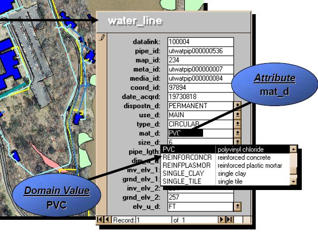
In map3d i would like to add tables to objects such gas, sewer lines and so forth. I would like to specify which lines are composed of certain metals, their conduit size and year built.
I was wondering if it is possible to create a table similar to the one attached. I would like the table to have a domain drop down list, so that users can select from predefined entries, to avoid human error typos and keep good organization in the data entry.
Is this possible with map3d?
Thank you in advance.
6 REPLIES 6
Message 2 of 7
12-04-2012
07:39 PM
- Mark as New
- Bookmark
- Subscribe
- Mute
- Subscribe to RSS Feed
- Permalink
- Report
12-04-2012
07:39 PM
You can create tables and attach records to the Autocad enties (lines, arc, etc) by using what is known as Object Data.
To have the predefined values with it requires you use classifed objects, classifiled objects is old school and not used much that I now of. To get the table (dialog) as in your image requires 3rd party appicaltions for AutoCad enities and the Object Data.
Now if you want to convert the autocad lines to Feature Data Objects (FDO) you may be able to create a SDF file or even SQL or other type of geospatial format if you have the servers/databases that may allow you to create the predefined values in a table.
So to answer you question, YES, as long as you use some customization or know database operations.
Murph
Supporting the troops daily.

Supporting the troops daily.
Message 3 of 7
12-04-2012
11:30 PM
- Mark as New
- Bookmark
- Subscribe
- Mute
- Subscribe to RSS Feed
- Permalink
- Report
12-04-2012
11:30 PM
Hi,
have a look as well at Industry Models - they provide domain tables as standard along many other interesting feature going beyond CAD. There are file based and database (enterprise) industry models:
http://usa.autodesk.com/autocad-map-3d/features/
There are industry models for water, wastewater, and afaik gas as well. Map documentation will give you detailed information.
Rob
http://raumpatrouille3d.blogspot.ch/
Message 4 of 7
12-05-2012
12:12 PM
- Mark as New
- Bookmark
- Subscribe
- Mute
- Subscribe to RSS Feed
- Permalink
- Report
12-05-2012
12:12 PM
@ro_fr wrote:Hi,
have a look as well at Industry Models - they provide domain tables as standard along many other interesting feature going beyond CAD. There are file based and database (enterprise) industry models:
http://usa.autodesk.com/autocad-map-3d/features/
There are industry models for water, wastewater, and afaik gas as well. Map documentation will give you detailed information.
Rob
Rob,
I was going to suggect that as well but I suspect the user is using an old version of Map3D.
Murph
Supporting the troops daily.
Supporting the troops daily.
Message 5 of 7
12-05-2012
03:34 PM
- Mark as New
- Bookmark
- Subscribe
- Mute
- Subscribe to RSS Feed
- Permalink
- Report
12-05-2012
03:34 PM
Thank you all for you responses.
First off, you mentioned there are 3rd party applications that will support drop downs lists, can you name them so I can look into them?
I cant believe map3d isnt able to do this simple operations of adding an entity and having attributes that drop down. I also looked in the metadata editor...has someone even been successful of adding a domain table there? Ive tried and nothing happens there.
I think the best option right now is looking into 3rd party applications.
I want to add SDSFIE table to my line drawings, and having them display the attributes in the properties table.
Message 6 of 7
12-05-2012
03:47 PM
- Mark as New
- Bookmark
- Subscribe
- Mute
- Subscribe to RSS Feed
- Permalink
- Report
Message 7 of 7
12-05-2012
07:22 PM
- Mark as New
- Bookmark
- Subscribe
- Mute
- Subscribe to RSS Feed
- Permalink
- Report
12-05-2012
07:22 PM
alekzab,
As I read it, you're real question is about having the valid values list that you can pick from? Map can do that with FDO pretty easily (doing it wil AutoCAD objects and object data will require development or 3rd party. If you use FDO with data files other than Shape files (shape doesn't support constraints) such as SDF of SQLite (my current favorite geodatabase), you can set up constraints in the fields to give you pull down lists. Take a look at the help files for that, ad if you have troubles, let me know and I'll make a video and blog about it.
Thanks,
Rick Chappell
Reply
Topic Options
- Subscribe to RSS Feed
- Mark Topic as New
- Mark Topic as Read
- Float this Topic for Current User
- Bookmark
- Subscribe
- Printer Friendly Page

