Community
Civil 3D Forum
Welcome to Autodesk’s Civil 3D Forums. Share your knowledge, ask questions, and explore popular AutoCAD Civil 3D topics.
Turn on suggestions
Auto-suggest helps you quickly narrow down your search results by suggesting possible matches as you type.
Reply
Topic Options
- Subscribe to RSS Feed
- Mark Topic as New
- Mark Topic as Read
- Float this Topic for Current User
- Bookmark
- Subscribe
- Printer Friendly Page
Message 1 of 15
09-29-2012
10:57 PM
- Mark as New
- Bookmark
- Subscribe
- Mute
- Subscribe to RSS Feed
- Permalink
- Report
09-29-2012
10:57 PM
Hi, I've got basejump going (broke it there for a while), but now I would really appreciate some pointers on using it effectively. I've got 2 main questions:
1. One thing that annoys me is that the Bing raster seems to want to jump up in the display order after a refresh/zoom so that it obsucres my other work. I couldn't find a layer that the imagery is associated with, so my only temporary solution at the moment is to zoom out (way out), select the image and "send to back". Also, ideally, I would like to load all 3 Bing options (aerial, roads, etc.), then have layers where I can turn them off and on as required. Is this possible?
2. Is it possible to copy of an aerial image from basejump and incorporate it into my drawing so that it works for others that might not use basejump? What I would like to do is get to the required zoom level, define an area of interest and then crop the image to this area and save it to a local disk or within the drawing itsefl
Any tips?
- Mick
Civil3d user in Australia since 2012.
Solved! Go to Solution.
Solved by neilyj666. Go to Solution.
14 REPLIES 14
Message 2 of 15
09-30-2012
02:17 AM
- Mark as New
- Bookmark
- Subscribe
- Mute
- Subscribe to RSS Feed
- Permalink
- Report
09-30-2012
02:17 AM
1. ensure MAPWSPACE is on, then simply drag the bing map layer below the basemap layer.
2. i'm not sure of the legal/copyright issues for this but don't think it can be done while connected to bing. If i was considering this i may create say 4 reference points and display coordinates, take a screen dump, and add the image back using ADERSHEET to rubberband it to the correct location.
AEC Collection 2025 UKIE (mainly Civil 3D UKIE and IW)
Win 11 Pro x64, 1Tb Primary SSD, 1Tb Secondary SSD
64Gb RAM Intel(R) Xeon(R) W-11855M CPU @ 3.2GHz
NVIDIA RTX A5000 16Gb, Dual 27" Monitor, Dell Inspiron 7760
2. i'm not sure of the legal/copyright issues for this but don't think it can be done while connected to bing. If i was considering this i may create say 4 reference points and display coordinates, take a screen dump, and add the image back using ADERSHEET to rubberband it to the correct location.
neilyj (No connection with Autodesk other than using the products in the real world)
Did you find this post helpful? Feel free to Like this post.
Did your question get successfully answered? Then click on the ACCEPT SOLUTION button.
AEC Collection 2025 UKIE (mainly Civil 3D UKIE and IW)
Win 11 Pro x64, 1Tb Primary SSD, 1Tb Secondary SSD
64Gb RAM Intel(R) Xeon(R) W-11855M CPU @ 3.2GHz
NVIDIA RTX A5000 16Gb, Dual 27" Monitor, Dell Inspiron 7760
Message 3 of 15
09-30-2012
02:18 AM
- Mark as New
- Bookmark
- Subscribe
- Mute
- Subscribe to RSS Feed
- Permalink
- Report
09-30-2012
02:18 AM
i forgot - mapwspace can be used to turn the map layers on or off
AEC Collection 2025 UKIE (mainly Civil 3D UKIE and IW)
Win 11 Pro x64, 1Tb Primary SSD, 1Tb Secondary SSD
64Gb RAM Intel(R) Xeon(R) W-11855M CPU @ 3.2GHz
NVIDIA RTX A5000 16Gb, Dual 27" Monitor, Dell Inspiron 7760
neilyj (No connection with Autodesk other than using the products in the real world)
Did you find this post helpful? Feel free to Like this post.
Did your question get successfully answered? Then click on the ACCEPT SOLUTION button.
AEC Collection 2025 UKIE (mainly Civil 3D UKIE and IW)
Win 11 Pro x64, 1Tb Primary SSD, 1Tb Secondary SSD
64Gb RAM Intel(R) Xeon(R) W-11855M CPU @ 3.2GHz
NVIDIA RTX A5000 16Gb, Dual 27" Monitor, Dell Inspiron 7760
Message 4 of 15
09-30-2012
03:12 AM
- Mark as New
- Bookmark
- Subscribe
- Mute
- Subscribe to RSS Feed
- Permalink
- Report
09-30-2012
03:12 AM
Thankyou Neilyj. exactly what I was after. Yes, I was starting to suspect that it wasn't meant to be easy to actually clip a part of the bing imagery out for later use.
Cheers
- Mick
Civil3d user in Australia since 2012.
Message 5 of 15
09-30-2012
03:19 AM
- Mark as New
- Bookmark
- Subscribe
- Mute
- Subscribe to RSS Feed
- Permalink
- Report
09-30-2012
03:19 AM
it would certainly be useful to clip out the imagery but I'm sure there are copyright issues re. google earth functionality removed from c3d 2013
AEC Collection 2025 UKIE (mainly Civil 3D UKIE and IW)
Win 11 Pro x64, 1Tb Primary SSD, 1Tb Secondary SSD
64Gb RAM Intel(R) Xeon(R) W-11855M CPU @ 3.2GHz
NVIDIA RTX A5000 16Gb, Dual 27" Monitor, Dell Inspiron 7760
neilyj (No connection with Autodesk other than using the products in the real world)
Did you find this post helpful? Feel free to Like this post.
Did your question get successfully answered? Then click on the ACCEPT SOLUTION button.
AEC Collection 2025 UKIE (mainly Civil 3D UKIE and IW)
Win 11 Pro x64, 1Tb Primary SSD, 1Tb Secondary SSD
64Gb RAM Intel(R) Xeon(R) W-11855M CPU @ 3.2GHz
NVIDIA RTX A5000 16Gb, Dual 27" Monitor, Dell Inspiron 7760
Message 6 of 15
09-30-2012
02:13 PM
- Mark as New
- Bookmark
- Subscribe
- Mute
- Subscribe to RSS Feed
- Permalink
- Report
09-30-2012
02:13 PM
@neilyj666 wrote:
it would certainly be useful to clip out the imagery but I'm sure there are copyright issues re. google earth functionality removed from c3d 2013
I don't know how basejump works but with other raster connections you couls zoom into the area you need, do a resample from the map task pane then export the map to dwg format. This would create a png (in your users temp folder) of the imaged displayed in the editor window that you could xref or insert into amother dwg.
Murph
Supporting the troops daily.

Supporting the troops daily.
Message 7 of 15
09-30-2012
05:56 PM
- Mark as New
- Bookmark
- Subscribe
- Mute
- Subscribe to RSS Feed
- Permalink
- Report
09-30-2012
05:56 PM
Nice one Murph !
Interesting.... resampling does indeed clip to the screen area. If I zoom in, the image updates to the higher resolution imagery - so it still dynamic, but it certainly seems quicker particularly zooming out as the whole geographic zone isn't being reloaded. If I zoom to extents, the full area is reloaded (effectively undoing the resampling operation), so not ideal from this perspective, but an easy way to reset the image.
I tried exporting, but as a dwg file it didn't seem to work. As a bmp file it worked, but there was no georeferencing information - so I guess would require the rubbersheeting as mentioned previously. Copying and pasting from one drawing to another didn't seem to work either. So it seems a few functions are either disabled or just don't work.
Aside from any potential copyright issues, it would still be nice to be able to save the image with georeferencing quickly and easily simply for my own use - like if the bing connection wasn't working one day, etc. etc.
Cheers
- Mick
Civil3d user in Australia since 2012.
Message 8 of 15
10-01-2012
12:19 AM
- Mark as New
- Bookmark
- Subscribe
- Mute
- Subscribe to RSS Feed
- Permalink
- Report
10-01-2012
12:19 AM
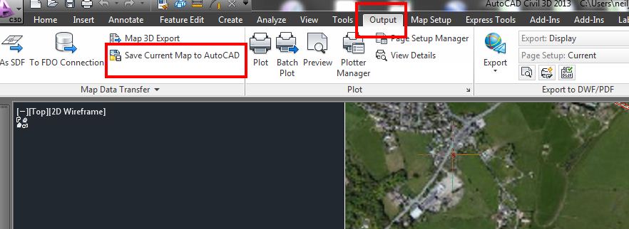
Murph to the rescue - again...!!!!![]()
@autoMick - did you Save Current Map to AutoCAD from the Output ribbon in Planning and Analysis workspace?? I did this and got a dwg of the base map although the resolution was very poor compared with the original "live" data.
neilyj (No connection with Autodesk other than using the products in the real world)
Did you find this post helpful? Feel free to Like this post.
Did your question get successfully answered? Then click on the ACCEPT SOLUTION button.
AEC Collection 2025 UKIE (mainly Civil 3D UKIE and IW)
Win 11 Pro x64, 1Tb Primary SSD, 1Tb Secondary SSD
64Gb RAM Intel(R) Xeon(R) W-11855M CPU @ 3.2GHz
NVIDIA RTX A5000 16Gb, Dual 27" Monitor, Dell Inspiron 7760
Message 9 of 15
10-01-2012
01:22 AM
- Mark as New
- Bookmark
- Subscribe
- Mute
- Subscribe to RSS Feed
- Permalink
- Report
10-01-2012
01:22 AM
If you wanna georeference an existing image physically loaded in the drawing, you should use this free tool:
http://www.cadstudio.cz/georefimg
Another technique involves the opensource Qgis, which loads Openlayers imagery, saving it as Geotiff.

Message 10 of 15
10-01-2012
04:59 AM
- Mark as New
- Bookmark
- Subscribe
- Mute
- Subscribe to RSS Feed
- Permalink
- Report
10-01-2012
04:59 AM
Neilyj - no I hadn't tried that, I just did export from the C3D menu. I tried your suggestion - and although it worked, I got the same result as you, the aerial photo was pretty shabby.
Antonio - thanks - looks like something to explore.
Cheers
- Mick
Civil3d user in Australia since 2012.
Message 11 of 15
10-01-2012
05:06 AM
- Mark as New
- Bookmark
- Subscribe
- Mute
- Subscribe to RSS Feed
- Permalink
- Report
10-01-2012
05:06 AM
I suppose this is the trade off for having "live" data for free....!!!
I use the Addin that Antonio mentions and it works well

neilyj (No connection with Autodesk other than using the products in the real world)
Did you find this post helpful? Feel free to Like this post.
Did your question get successfully answered? Then click on the ACCEPT SOLUTION button.
AEC Collection 2025 UKIE (mainly Civil 3D UKIE and IW)
Win 11 Pro x64, 1Tb Primary SSD, 1Tb Secondary SSD
64Gb RAM Intel(R) Xeon(R) W-11855M CPU @ 3.2GHz
NVIDIA RTX A5000 16Gb, Dual 27" Monitor, Dell Inspiron 7760
Message 12 of 15
01-18-2013
05:28 AM
- Mark as New
- Bookmark
- Subscribe
- Mute
- Subscribe to RSS Feed
- Permalink
- Report
01-18-2013
05:28 AM
I cannot get that Addin that Antonio mentions to work as the image that basejump gives is not an image. How can you say it works well? Yea I can install it and a fancy ribbon pops up but it does not solve the problem.
Edited by
Discussion_Admin
Message 13 of 15
01-18-2013
06:18 AM
- Mark as New
- Bookmark
- Subscribe
- Mute
- Subscribe to RSS Feed
- Permalink
- Report
01-18-2013
06:18 AM
@Anonymous wrote:I cannot get that Addin that Antonio mentions to work as the image that basejump gives is not an image. How can you say it works well? Yea I can install it and a fancy ribbon pops up but it does not solve the problem. How can you call yourself an *expert elite*, that laughable.
What exactly is the problem??
@Anonymous wrote:I cannot get that Addin that Antonio mentions to work as the image that basejump gives is not an image. How can you say it works well? Yea I can install it and a fancy ribbon pops up but it does not solve the problem. How can you call yourself an *expert elite*, that laughable.
Please don't blame me for what the program can and cannot do or for your competence or not in using the information: I just click the buttons and try to find a workaround - as do all the other Expert Elites.
neilyj (No connection with Autodesk other than using the products in the real world)
Did you find this post helpful? Feel free to Like this post.
Did your question get successfully answered? Then click on the ACCEPT SOLUTION button.
AEC Collection 2025 UKIE (mainly Civil 3D UKIE and IW)
Win 11 Pro x64, 1Tb Primary SSD, 1Tb Secondary SSD
64Gb RAM Intel(R) Xeon(R) W-11855M CPU @ 3.2GHz
NVIDIA RTX A5000 16Gb, Dual 27" Monitor, Dell Inspiron 7760
Message 14 of 15
01-18-2013
10:12 AM
- Mark as New
- Bookmark
- Subscribe
- Mute
- Subscribe to RSS Feed
- Permalink
- Report
01-18-2013
10:12 AM
Dr Etch:
If it is not an image, what is it?
"An image (from Latin: imago) is an artifact that depicts or records visual perception, for example a two-dimensional picture . ."
BTW, we did not give ourselves this title.
Bill
Message 15 of 15
01-18-2013
10:40 AM
- Mark as New
- Bookmark
- Subscribe
- Mute
- Subscribe to RSS Feed
- Permalink
- Report
01-18-2013
10:40 AM
The entity is a "ACMAPGISGRIDSURFACEENTITY' that cannot be editted in any way. It cannot be exploded, moved, aligned rotated or transformed in any way.
Edited by
Discussion_Admin
Reply
Topic Options
- Subscribe to RSS Feed
- Mark Topic as New
- Mark Topic as Read
- Float this Topic for Current User
- Bookmark
- Subscribe
- Printer Friendly Page
Forums Links
Can't find what you're looking for? Ask the community or share your knowledge.
Post to forums

