Community
Civil 3D Forum
Welcome to Autodesk’s Civil 3D Forums. Share your knowledge, ask questions, and explore popular AutoCAD Civil 3D topics.
Turn on suggestions
Auto-suggest helps you quickly narrow down your search results by suggesting possible matches as you type.
Reply
Topic Options
- Subscribe to RSS Feed
- Mark Topic as New
- Mark Topic as Read
- Float this Topic for Current User
- Bookmark
- Subscribe
- Printer Friendly Page
Message 1 of 2
06-08-2012
06:41 AM
- Mark as New
- Bookmark
- Subscribe
- Mute
- Subscribe to RSS Feed
- Permalink
- Report
06-08-2012
06:41 AM
Two Intersecting Alignments
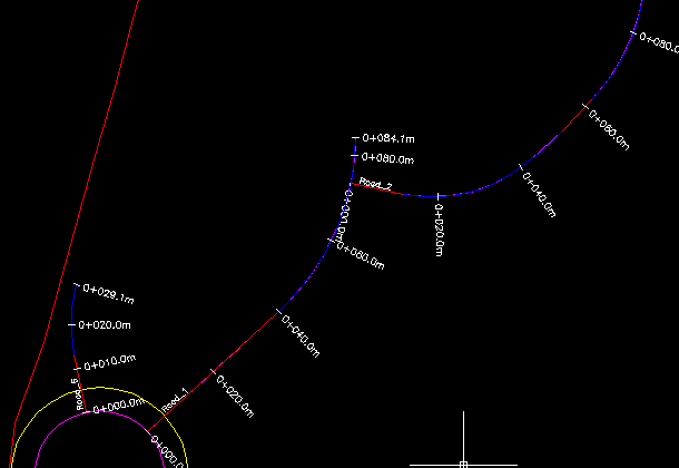
How do I project the Proposed Road Level information from Road_1 at the intersection of Road_2 (Alignment_GA.jpg) onto the Start of the Profile for Road_2 (Alignment_Profile.jpg) to give me my tie in start point?
How do I obtain the exact chaiange of the intersection Point?
How can i extend Road_2 onto the horizontal curve of Road_1 so i know they exactly intersect?
Any help would be much appreciated
Reagrds
Dean
1 REPLY 1
Message 2 of 2
06-08-2012
09:00 AM
- Mark as New
- Bookmark
- Subscribe
- Mute
- Subscribe to RSS Feed
- Permalink
- Report
06-08-2012
09:00 AM
Others might have different options, but here's how I handle these situations:
@zebadee wrote:How do I project the Proposed Road Level information from Road_1 at the intersection of Road_2 (Alignment_GA.jpg) onto the Start of the Profile for Road_2 (Alignment_Profile.jpg) to give me my tie in start point?
Create a surface from the corridor for alignment 1. Either Query or Label the intersection point with a station/offset label that includes a reference text component for Surface Elevation. Use that elevation as the starting elevation for Alignment 2.
@zebadee wrote:
How do I obtain the exact chaiange of the intersection Point?
See above. This label will include station value. (Chainage = Station, right?)
@zebadee wrote:
How can i extend Road_2 onto the horizontal curve of Road_1 so i know they exactly intersect?
Explode down to a polyline, use Extend to extend the polyline to Align 1, create Align 2 from the polyline.
Tim Corey
MicroCAD Training and Consulting, Inc.
Redding, CA
Autodesk Gold Reseller
New knowledge is the most valuable commodity on earth. -- Kurt Vonnegut
Reply
Topic Options
- Subscribe to RSS Feed
- Mark Topic as New
- Mark Topic as Read
- Float this Topic for Current User
- Bookmark
- Subscribe
- Printer Friendly Page

