Community
Civil 3D Forum
Welcome to Autodesk’s Civil 3D Forums. Share your knowledge, ask questions, and explore popular AutoCAD Civil 3D topics.
Turn on suggestions
Auto-suggest helps you quickly narrow down your search results by suggesting possible matches as you type.
Reply
Topic Options
- Subscribe to RSS Feed
- Mark Topic as New
- Mark Topic as Read
- Float this Topic for Current User
- Bookmark
- Subscribe
- Printer Friendly Page
Message 1 of 5
02-22-2013
11:43 AM
- Mark as New
- Bookmark
- Subscribe
- Mute
- Subscribe to RSS Feed
- Permalink
- Report
02-22-2013
11:43 AM
Survey Data
Hello,
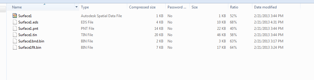
I recieved some data today from an outside surveyor who was obviosuly using LDD. The information I recieved outside of the actual survey autocad mapping was a Autocad .dtm file with the tin linework in it and a zip file with the files shown in the attached document.
Woudl anyone know what the best way to import the surface in the survey master file would be? Would the ideal way to do this to be to create surface from TIN?
4 REPLIES 4
Message 2 of 5
02-22-2013
12:50 PM
- Mark as New
- Bookmark
- Subscribe
- Mute
- Subscribe to RSS Feed
- Permalink
- Report
02-22-2013
12:50 PM
It has been awhile but I believe you are correct with the TIN creation. You should be getting an identical TIN that incorporates all of their edits.
Civil 3D 2022.1
Windows 10 x64
HP ZBook 15 G5
Intel(R) Core(TM) i7-8750H CPU @ 2.60GHz
32 GB RAM
Windows 10 x64
HP ZBook 15 G5
Intel(R) Core(TM) i7-8750H CPU @ 2.60GHz
32 GB RAM
Message 3 of 5
02-24-2013
01:57 PM
- Mark as New
- Bookmark
- Subscribe
- Mute
- Subscribe to RSS Feed
- Permalink
- Report
Message 4 of 5
02-25-2013
06:38 AM
- Mark as New
- Bookmark
- Subscribe
- Mute
- Subscribe to RSS Feed
- Permalink
- Report
02-25-2013
06:38 AM
If the zip file contains relative paths. Unzip it and allow those paths to be used. If not. Set it up in the standard LDT format; Project Path > Project Name > DTM, Cogo, Align. Then you can import the surface and other dated from Import on the Insert tab.
Usually it is best to leave the surface as the Surveyor supplied it. However, if you need a dynamic surface. If the point and breaklines were supplied in the drawing. You can import the points and breaklines and use them to create a surface.
Allen Jessup
CAD Manager - Designer
Did you find this post helpful? Feel free to Like this post.
Did your question get successfully answered? Then click on the ACCEPT SOLUTION button.
Message 5 of 5
02-25-2013
07:04 AM
- Mark as New
- Bookmark
- Subscribe
- Mute
- Subscribe to RSS Feed
- Permalink
- Report
02-25-2013
07:04 AM
There is a Civil 3D command called CREATESURFACEFROMTIN that will import those files directly. As far as I know, this command only requires the TIN and PNT files, but it's best to keep them all together. Make sure that you keep them in a common location and that you don't move it.
--
Ralph Sanchez
Ralph Sanchez
Reply
Topic Options
- Subscribe to RSS Feed
- Mark Topic as New
- Mark Topic as Read
- Float this Topic for Current User
- Bookmark
- Subscribe
- Printer Friendly Page

