Community
Civil 3D Forum
Welcome to Autodesk’s Civil 3D Forums. Share your knowledge, ask questions, and explore popular AutoCAD Civil 3D topics.
Turn on suggestions
Auto-suggest helps you quickly narrow down your search results by suggesting possible matches as you type.
Reply
Topic Options
- Subscribe to RSS Feed
- Mark Topic as New
- Mark Topic as Read
- Float this Topic for Current User
- Bookmark
- Subscribe
- Printer Friendly Page
Message 1 of 6
01-23-2014
10:40 AM
- Mark as New
- Bookmark
- Subscribe
- Mute
- Subscribe to RSS Feed
- Permalink
- Report
01-23-2014
10:40 AM
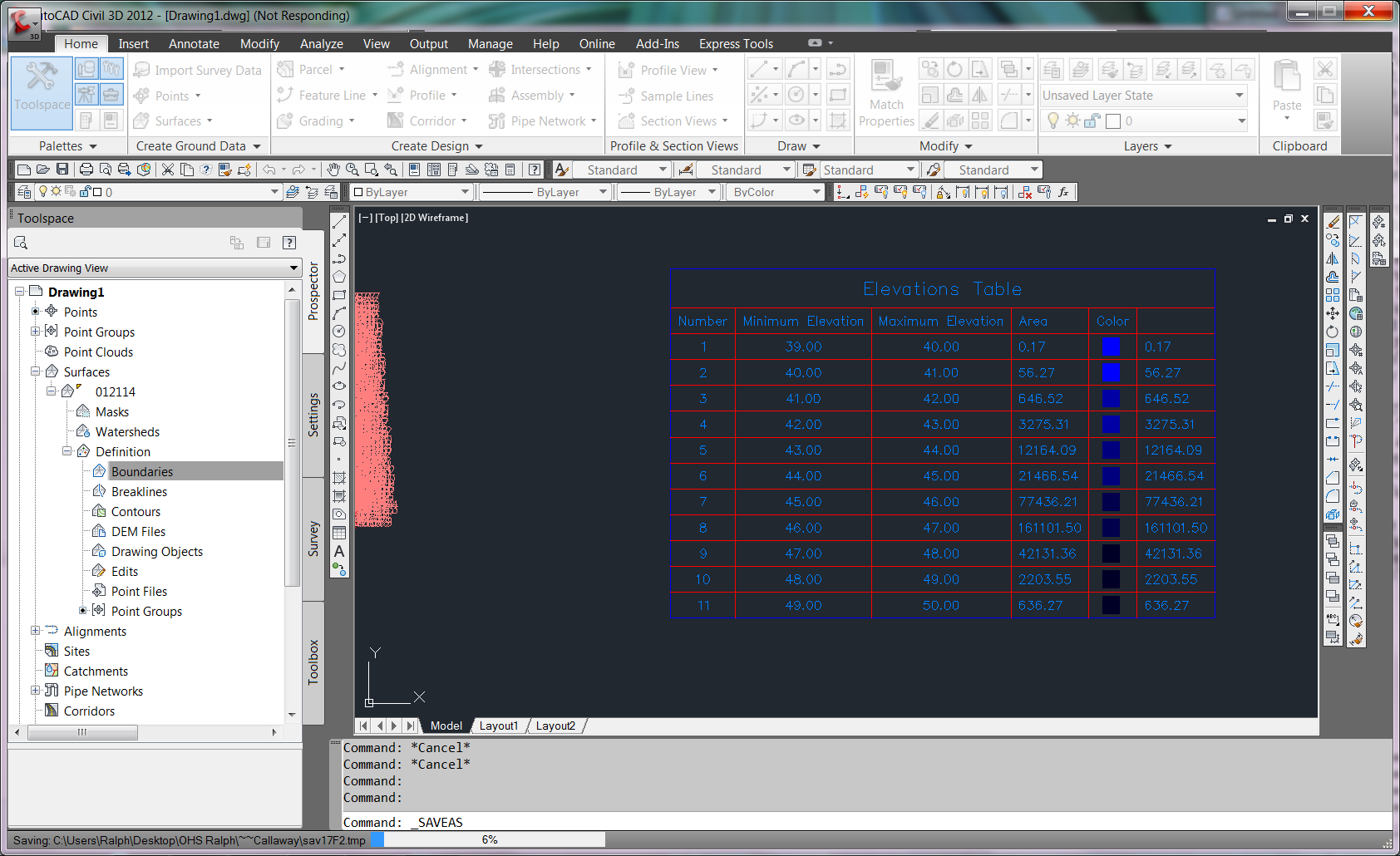
can someone please give me a definition of what exactly this is? i just created a table but need to know what the numbers mean and googling is useless, see attached table, for speaking purposes, number 5 which is 43' to 44', what is the 12,164.09 area????
Solved! Go to Solution.
Solved by neilyj666. Go to Solution.
5 REPLIES 5
Message 2 of 6
01-23-2014
11:04 AM
- Mark as New
- Bookmark
- Subscribe
- Mute
- Subscribe to RSS Feed
- Permalink
- Report
01-23-2014
11:04 AM
My understanding of these areas is that if you imagine a series of concentric circles the lowest value i.e.Number 1 represents the smallest circle. Number 2 represents the annular area between circle 1 and 2, Number 3 is the annular area between 2 and 3 etc.
Thus the area for Number 5 only represents the area between 44' and 45' (so for say a flood level of 45' the area flooded would be the sum of the areas 1 to 5) and the total of all the areas should equal the total surface area (2D)
neilyj (No connection with Autodesk other than using the products in the real world)
Did you find this post helpful? Feel free to Like this post.
Did your question get successfully answered? Then click on the ACCEPT SOLUTION button.
AEC Collection 2024 UKIE (mainly Civil 3D UKIE and IW)
Win 11 Pro x64, 1Tb Primary SSD, 1Tb Secondary SSD
64Gb RAM Intel(R) Xeon(R) W-11855M CPU @ 3.2GHz
NVIDIA RTX A5000 16Gb, Dual 27" Monitor, Dell Inspiron 7760
Message 3 of 6
01-23-2014
11:28 AM
- Mark as New
- Bookmark
- Subscribe
- Mute
- Subscribe to RSS Feed
- Permalink
- Report
01-23-2014
11:28 AM
cool, thanks ... are you sure this is right? would like one more person to chime in on this unless you are sure
also, the topography is definitely not uniform as you describe in your example, there will be tiny little islands, 100's of them between certain elevation ranges, I am hoping it accounts for this, no idea how this could be be computed but i have faith in the great god of civil 3d
also, the topography is definitely not uniform as you describe in your example, there will be tiny little islands, 100's of them between certain elevation ranges, I am hoping it accounts for this, no idea how this could be be computed but i have faith in the great god of civil 3d
Message 4 of 6
01-23-2014
01:30 PM
- Mark as New
- Bookmark
- Subscribe
- Mute
- Subscribe to RSS Feed
- Permalink
- Report
01-23-2014
01:30 PM
my example was just that to illustrate the concept. I'm pretty sure that all the little islands are accounted for- check the total adds up to the surface area. You could extract user contours and calculate the area between them.
AEC Collection 2024 UKIE (mainly Civil 3D UKIE and IW)
Win 11 Pro x64, 1Tb Primary SSD, 1Tb Secondary SSD
64Gb RAM Intel(R) Xeon(R) W-11855M CPU @ 3.2GHz
NVIDIA RTX A5000 16Gb, Dual 27" Monitor, Dell Inspiron 7760
neilyj (No connection with Autodesk other than using the products in the real world)
Did you find this post helpful? Feel free to Like this post.
Did your question get successfully answered? Then click on the ACCEPT SOLUTION button.
AEC Collection 2024 UKIE (mainly Civil 3D UKIE and IW)
Win 11 Pro x64, 1Tb Primary SSD, 1Tb Secondary SSD
64Gb RAM Intel(R) Xeon(R) W-11855M CPU @ 3.2GHz
NVIDIA RTX A5000 16Gb, Dual 27" Monitor, Dell Inspiron 7760
Message 5 of 6
01-23-2014
03:03 PM
- Mark as New
- Bookmark
- Subscribe
- Mute
- Subscribe to RSS Feed
- Permalink
- Report
01-23-2014
03:03 PM
Yup Neilyj is right, for your particluar example, the area for number 5 is everything in your surface between elevations 43 and 44.
Message 6 of 6
01-24-2014
06:11 AM
- Mark as New
- Bookmark
- Subscribe
- Mute
- Subscribe to RSS Feed
- Permalink
- Report
Reply
Topic Options
- Subscribe to RSS Feed
- Mark Topic as New
- Mark Topic as Read
- Float this Topic for Current User
- Bookmark
- Subscribe
- Printer Friendly Page

