Community
Civil 3D Forum
Welcome to Autodesk’s Civil 3D Forums. Share your knowledge, ask questions, and explore popular AutoCAD Civil 3D topics.
Turn on suggestions
Auto-suggest helps you quickly narrow down your search results by suggesting possible matches as you type.
Reply
Topic Options
- Subscribe to RSS Feed
- Mark Topic as New
- Mark Topic as Read
- Float this Topic for Current User
- Bookmark
- Subscribe
- Printer Friendly Page
Message 1 of 13
Anonymous
2985 Views, 12 Replies
08-08-2012
09:59 PM
- Mark as New
- Bookmark
- Subscribe
- Mute
- Subscribe to RSS Feed
- Permalink
- Report
08-08-2012
09:59 PM
Hi All!
I was tried to convert a point from UTM-39N to Lat/Long using geodetic calculator; but when I checked the converted coordinates by another applications (like GeoLab); they were a little different (about two seconds) & I'm sure GeoLab is right. Any Help?
My settings and other information is attached.
Sorry for poor English
Thank you.
Solved! Go to Solution.
12 REPLIES 12
Message 2 of 13
08-08-2012
11:00 PM
- Mark as New
- Bookmark
- Subscribe
- Mute
- Subscribe to RSS Feed
- Permalink
- Report
08-08-2012
11:00 PM
Try another way: first _MAPEXPORT it to a point shapefile in LL84, then _MAPIMPORT it back to check the precision.

Message 3 of 13
08-09-2012
12:42 AM
- Mark as New
- Bookmark
- Subscribe
- Mute
- Subscribe to RSS Feed
- Permalink
- Report
08-09-2012
12:42 AM
thanks, but unfortunately it doesn't work.
my question is why this had happened?
my question is why this had happened?
Message 4 of 13
08-09-2012
12:46 AM
- Mark as New
- Bookmark
- Subscribe
- Mute
- Subscribe to RSS Feed
- Permalink
- Report
08-09-2012
12:46 AM
Please attach that UTM-39N point in DWG format, and paste here the expected LL84 coords, thanks.
Message 5 of 13
08-09-2012
01:31 AM
- Mark as New
- Bookmark
- Subscribe
- Mute
- Subscribe to RSS Feed
- Permalink
- Report
08-09-2012
01:31 AM
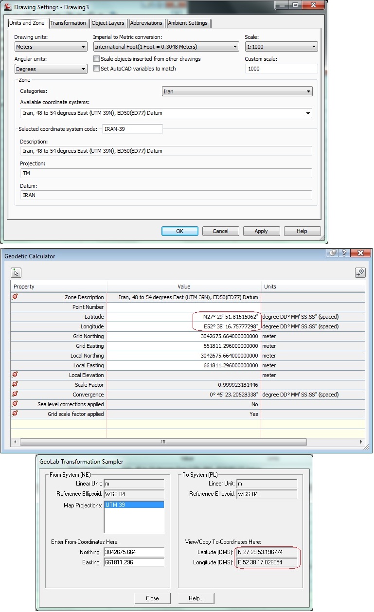
Expected latitude and longitude is:
Lat: N27° 29' 53.196774"
Long: E52° 38' 17.028054"
and what Civil3D give me is:
Lat: N27° 29' 51.8162"
Long: : E52° 38' 16.7578"
and the drawing that have the point is attached (Civil 3D 2012).
thanks.
Message 6 of 13
08-09-2012
02:59 AM
- Mark as New
- Bookmark
- Subscribe
- Mute
- Subscribe to RSS Feed
- Permalink
- Report
08-09-2012
02:59 AM
Well, I tried to convert your EPSG:2059 point (X = 661811.296 , Y = 3042675.664) to EPSG:4326 (i.e. Lat-Long datum WGS84) with two different softwares, and here are my results.
1] Quantum Gis yields
LONG = 52.63811871
LAT = 27.49647281
2] Autocad Map2006 yields
LONG = 52.63815850
LAT = 27.49648261
then I calculated the HH'MM'SS' format here: http://www.earthpoint.us/Convert.aspx
The Qgis coords are: 27°29'47.3021", 052°38'17.2274"
The Autocad coords are: 27°29'47.3374", 052°38'17.3706"
As you can see, there's a LONG difference of 0.1432" and a LAT of 0.0353, yielding a 4 meters shift in LONG, and 1 meter in LAT.
Since two dfferent tools gave an almost identical result, I guess your expected coords Lat: N27° 29' 53.196774" Long: E52° 38' 17.028054" are simply wrong, sir.
Message 7 of 13
08-09-2012
01:04 PM
- Mark as New
- Bookmark
- Subscribe
- Mute
- Subscribe to RSS Feed
- Permalink
- Report
08-09-2012
01:04 PM
I work in an oil and gas company and I almost always have to convert Bench marks coords to lat/long or from lat/long coords. because of my job, the converted coords must have high accuracy (often 3mm) and when I use Geolab, I get this precision. I used to check Geolab with a high accuracy routine in MATLAB; so I trust Geolab. ![]()
Any Idea?
Thanks.
Message 9 of 13
08-13-2012
03:21 AM
- Mark as New
- Bookmark
- Subscribe
- Mute
- Subscribe to RSS Feed
- Permalink
- Report
08-13-2012
03:21 AM
Yes! I think pipe supports and their bolts, pipe equipments like boilers and etc. need that precision.
However I said I want that accuracy for the Bench marks!
Message 10 of 13
Anonymous
in reply to:
Anonymous
08-13-2012
12:17 PM
- Mark as New
- Bookmark
- Subscribe
- Mute
- Subscribe to RSS Feed
- Permalink
- Report
08-13-2012
12:17 PM
Everybody is correct!
The problem is we are using different horizontal datums, in your autocad image you used the European Datum, but in the GeoLab you used WGS84. I'm not sure what other people are using. To check AutoCAD against GeoLab I used WGS84, the same that you used in GeoLab and the resultant coordinates matched, see below:

I STRONGLY suggest that you confirm what datum you are using. People not understanding horizontal (and vertical) datums can lead to very costly mistakes.
As a PLS this is always something I fear, when people start converting coordinates I start getting phone calls at 2 in the morning. I suggest you talk to your surveyor about your projects coordinate system, I'm sure they will tell you the same.
Thanks,
Mark
Message 12 of 13
08-14-2012
05:40 AM
- Mark as New
- Bookmark
- Subscribe
- Mute
- Subscribe to RSS Feed
- Permalink
- Report
08-14-2012
05:40 AM
I beg your pardon, mr.Musasalemi.
I was misled by your TEST.DWG which contains an incorrect _ADESETCRDSYS value, referring to the wrong datum...
Message 13 of 13
08-14-2012
09:06 AM
- Mark as New
- Bookmark
- Subscribe
- Mute
- Subscribe to RSS Feed
- Permalink
- Report
Reply
Topic Options
- Subscribe to RSS Feed
- Mark Topic as New
- Mark Topic as Read
- Float this Topic for Current User
- Bookmark
- Subscribe
- Printer Friendly Page
Forums Links
Can't find what you're looking for? Ask the community or share your knowledge.
Post to forums

