Community
Civil 3D Forum
Welcome to Autodesk’s Civil 3D Forums. Share your knowledge, ask questions, and explore popular AutoCAD Civil 3D topics.
Turn on suggestions
Auto-suggest helps you quickly narrow down your search results by suggesting possible matches as you type.
Reply
Topic Options
- Subscribe to RSS Feed
- Mark Topic as New
- Mark Topic as Read
- Float this Topic for Current User
- Bookmark
- Subscribe
- Printer Friendly Page
Message 1 of 5
12-20-2012
04:28 PM
- Mark as New
- Bookmark
- Subscribe
- Mute
- Subscribe to RSS Feed
- Permalink
- Report
12-20-2012
04:28 PM
Grading filling in embankment
Hi
1do I create feature lines at toe , then vertical between the toe and the cliff , then use the grading & elev.editor
2 Once I obtain the infill surface l, how rotate or orient the model w/ rocks so this photo 3
is draped over it.?.
TY
4 REPLIES 4
Message 2 of 5
12-20-2012
05:04 PM
- Mark as New
- Bookmark
- Subscribe
- Mute
- Subscribe to RSS Feed
- Permalink
- Report
12-20-2012
05:04 PM
@eyescast wrote:Hi
1do I create feature lines at toe , then vertical between the toe and the cliff , then use the grading & elev.editor
2 Once I obtain the infill surface l, how rotate or orient the model w/ rocks so this photo 3
is draped over it.?.
TY
Not too sure I understand your prose are you asking how to grade or how to get an image ine you drawing?
Your Name
Did you find this post helpful? Feel free to Like this post.
Did your question get successfully answered? Then click on the ACCEPT SOLUTION button.
Message 3 of 5
01-15-2013
06:07 PM
- Mark as New
- Bookmark
- Subscribe
- Mute
- Subscribe to RSS Feed
- Permalink
- Report
01-15-2013
06:07 PM
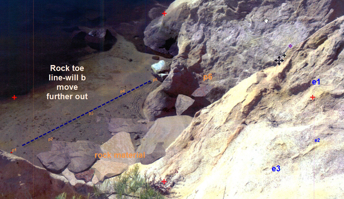
Hi again, The forum give me an error message of limiting it 80 characters......sorry about that. 1. Is the best way to create the design surface is by creating a feature lines and then creating grading objects? Is this is the only way? If that is so, how do i create a FILL grading group for an eroded embankment of a reservoir. The examples on a typical book eg."master civil 3d 2012" shows a pond design. I started a polyline boundary area just a bit smaller than cogo points consists of - surveypoints shot on the edge on the cliff, shot midway to wall of the cliff and shots taken to where the toe of rip rap fill-boundary should be. After that , i added points with elevations which represent whats on the site. (See image) . is this correct? on the base feature boundary, do i just tell what lenght of the boundary line it must be graded from the top of the cliff, 1:2 slope ? And when I get to the portion of the base feature bounary line at the toe , I just tell what lenght of the boundary line it must be with a slope of 1:1.5 2. This I'm about to try to model the the design surface a different way. (from the cliff 1:2, it goes this way for 5 ft, changes to 1:1.5) do I create feature lines at toe , then vertical feature line between the toe and the cliff , then use the grading editor or elevation editor 3. Once I obtain the infill surface of the fill, how rotate or orient the model , ( rock material - rendered) so this photo 2 is draped over it.? Thanks again. Sincerely, Joseph R Cruz Water Resources Engineer SOUTHERN FIELD DIVISION State of California Department of Water Resources Southern Field Division 34534 116th Street East P.O. Box 1187 Pearblossom, CA 903553 661.944.8567 Off. 661.805.0210 Cell 661.944.8576 Fax jcruz@water.ca.gov [cid:image003.png@01CBD335.00047290]
Message 4 of 5
01-15-2013
09:26 PM
- Mark as New
- Bookmark
- Subscribe
- Mute
- Subscribe to RSS Feed
- Permalink
- Report
01-15-2013
09:26 PM
I'm having difficulty reading through your post and isolating all of the separate questions that you're asking. Let's see if I can clear up one or two of them at least.
Is the best way to create the design surface is by creating a feature lines and then creating grading objects? Is this is the only way? If that is so, how do i create a FILL grading group for an eroded embankment of a reservoir.
For this situation it sounds like a grading object would be appropriate at least to start from. The problem you may run into is that a grading always projects perpendicular to its baseline. If you're starting from the top of the collapsed bank then it looks like you don't have a straight line to work from. If you have a slope break in the middle of the design then you may be able to project in both directions from there.
Once I obtain the infill surface of the fill, how rotate or orient the model , ( rock material - rendered) so this photo 2 is draped over it.?
Insert your photo into the drawing. Move and scale it so that it covers the extents of your surface. Use the Drape Image tool to render the image onto the surface. You'll have to use a surface style that displays triangles and switch the visual style to Realistic to see the photo.
Steve
Expert Elite Alumnus
Expert Elite Alumnus
Message 5 of 5
01-16-2013
03:08 AM
- Mark as New
- Bookmark
- Subscribe
- Mute
- Subscribe to RSS Feed
- Permalink
- Report
01-16-2013
03:08 AM
Maybe you could create your design surface just by a series of feature lines representing your grade break points. Add these feature lines to a surface (as contours or breaklines I think will work). Are you trying to determine the volume of fill required, or just simply draw the design surface? will you be modify the existing terrain or just filling the gaps?
A sketch of a cross section would help.
Civil3d user in Australia since 2012.
Reply
Topic Options
- Subscribe to RSS Feed
- Mark Topic as New
- Mark Topic as Read
- Float this Topic for Current User
- Bookmark
- Subscribe
- Printer Friendly Page

