Community
- Forums Home
- >
- Civil 3D Community
- >
- Civil 3D Forum
- >
- Grading Fill on a collapse embankment- a reposting
Civil 3D Forum
Welcome to Autodesk’s Civil 3D Forums. Share your knowledge, ask questions, and explore popular AutoCAD Civil 3D topics.
Turn on suggestions
Auto-suggest helps you quickly narrow down your search results by suggesting possible matches as you type.
Reply
Topic Options
- Subscribe to RSS Feed
- Mark Topic as New
- Mark Topic as Read
- Float this Topic for Current User
- Bookmark
- Subscribe
- Printer Friendly Page
Message 1 of 3
12-20-2012
07:04 PM
- Mark as New
- Bookmark
- Subscribe
- Mute
- Subscribe to RSS Feed
- Permalink
- Report
12-20-2012
07:04 PM
Grading Fill on a collapse embankment- a reposting
1.
Is the best way to create a design surface having a feature lines and then creating grading objects?
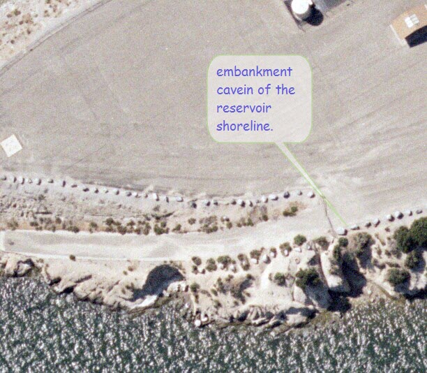
Then how do i create a FILL grading group for an eroded embankment of a reservoir. The examples on a typical book eg."master civil 3d 2012" shows a pond design.
I started a polyline boundary area just a bit smaller than cogo points consist of - surveypoints shot on the edge on the cliff, shot midway to wall of the cliff and shots taken to where the toe of rip rap fill-boundary should be.More points were created with elevations which represent whats on the site. (See image) . is this correct?
On the base feature boundary, do i just tell what lenght of the boundary line it must be graded from the top of the cliff, 1:2 slope and when I get to the portion of the base feature bounary line at the toe , I just tell how far the length of the boundary line is the and give a slope value of 1:1.5. Should this work
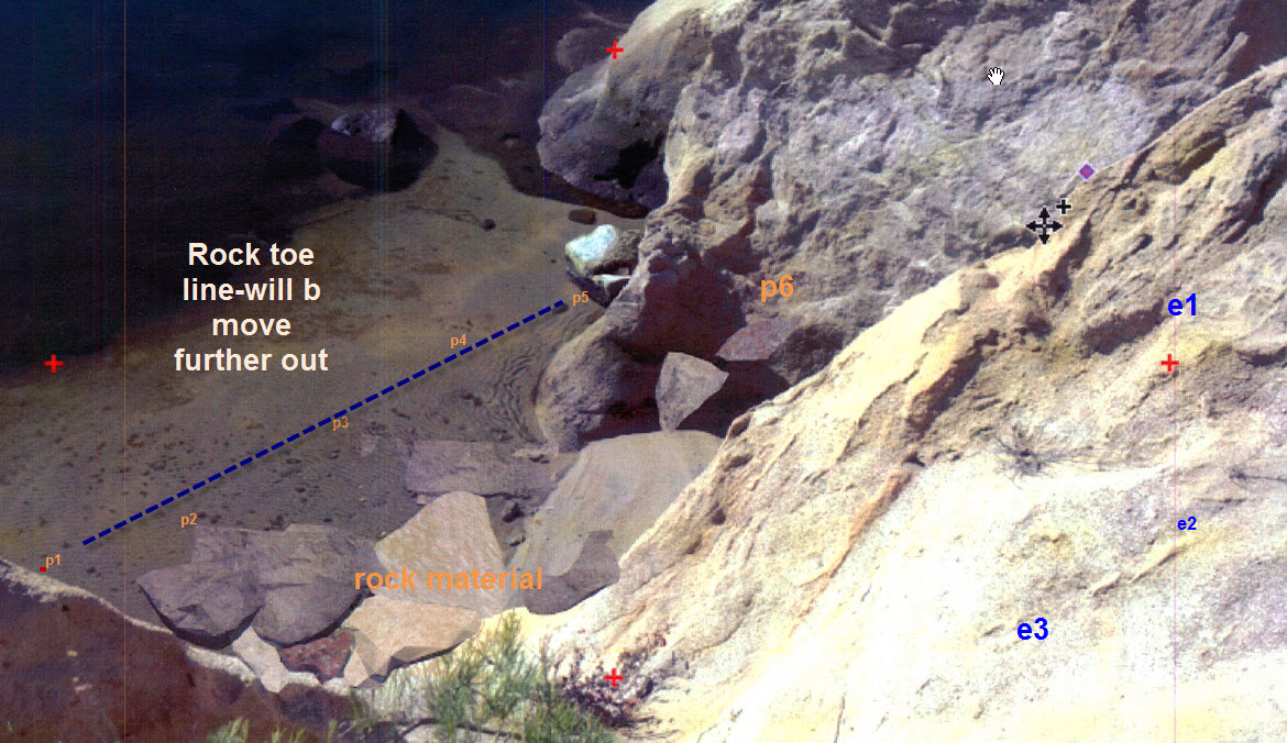
2. I'm about to try to model the the design surface a different way. (from the cliff 1:2, it goes this way for 5 ft, changes to 1:1.5)
do I create feature lines at toe , then vertical feature line between the toe and the cliff , then use the grading editor or elevation editor
3. Once I obtain the infill surface of the fill, how rotate or orient the model , ( rock material - rendered) so Photo 3 is draped over it.?
Thanks again.
2 REPLIES 2
Message 2 of 3
12-21-2012
09:41 AM
- Mark as New
- Bookmark
- Subscribe
- Mute
- Subscribe to RSS Feed
- Permalink
- Report
12-21-2012
09:41 AM
I think you would benefit greatly by hiring a Civil 3D specialist in your area to come out and help you for half-a-day.
Tim Corey
MicroCAD Training and Consulting, Inc.
Redding, CA
Autodesk Gold Reseller
New knowledge is the most valuable commodity on earth. -- Kurt Vonnegut
Message 3 of 3
12-21-2012
02:26 PM
- Mark as New
- Bookmark
- Subscribe
- Mute
- Subscribe to RSS Feed
- Permalink
- Report
12-21-2012
02:26 PM
You are very kind
Your Name
Did you find this post helpful? Feel free to Like this post.
Did your question get successfully answered? Then click on the ACCEPT SOLUTION button.
Your Name
Reply
Topic Options
- Subscribe to RSS Feed
- Mark Topic as New
- Mark Topic as Read
- Float this Topic for Current User
- Bookmark
- Subscribe
- Printer Friendly Page

