Community
Civil 3D Forum
Welcome to Autodesk’s Civil 3D Forums. Share your knowledge, ask questions, and explore popular AutoCAD Civil 3D topics.
Turn on suggestions
Auto-suggest helps you quickly narrow down your search results by suggesting possible matches as you type.
Reply
Topic Options
- Subscribe to RSS Feed
- Mark Topic as New
- Mark Topic as Read
- Float this Topic for Current User
- Bookmark
- Subscribe
- Printer Friendly Page
Message 1 of 17
Anonymous
8625 Views, 16 Replies
07-07-2011
12:37 PM
- Mark as New
- Bookmark
- Subscribe
- Mute
- Subscribe to RSS Feed
- Permalink
- Report
07-07-2011
12:37 PM
Calc Area in Acres
Hello,
Before 2011 came along we had a lsp routine for acre that would give us the area of any polylines in acres. In 2011 this same routine does not work. I can enter in "acre" at the command line and it ask to pick polyline for area. When I click on the polyline it just says "nil"
Anyone know why this is. The code we have for acre is below.
(defun c:ACRE (/ )
(setq pentity (car(entsel "\nPick polyline for area: ")))
(command "area" "e" pentity)
(setq area1 (getvar "area"))
(setq acreage (/ area1 43560.0))
(setq acre (rtos acreage 2 2))
(setq art (strcat " = " acre " Acres" (chr 13)))
(setq sqrft (strcat "Area = " (rtos area1 2 0) " SqFt"))
(setq art_sqrft (strcat sqrft art))
(PROMPT art_sqrft)
)
16 REPLIES 16
Message 2 of 17
07-07-2011
01:02 PM
- Mark as New
- Bookmark
- Subscribe
- Mute
- Subscribe to RSS Feed
- Permalink
- Report
07-07-2011
01:02 PM
I cannot help on your code but just offer a plan B.
Autocad's FIELD command can be a fairly easy method.
Bill
Message 3 of 17
07-07-2011
01:07 PM
- Mark as New
- Bookmark
- Subscribe
- Mute
- Subscribe to RSS Feed
- Permalink
- Report
Message 4 of 17
07-07-2011
01:42 PM
- Mark as New
- Bookmark
- Subscribe
- Mute
- Subscribe to RSS Feed
- Permalink
- Report
07-07-2011
01:42 PM
I know the direct question was why doesn't the lisp work but....How about setting your default area label style for CreateParcelFromObject to something setup for acres and just create temporary parcels from the polylines with acre labels? Just a suggestion for using the capabilities of the software rather than deferring to old lisp routines.
Civil 3D 2022.1
Windows 10 x64
HP ZBook 15 G5
Intel(R) Core(TM) i7-8750H CPU @ 2.60GHz
32 GB RAM
Windows 10 x64
HP ZBook 15 G5
Intel(R) Core(TM) i7-8750H CPU @ 2.60GHz
32 GB RAM
Message 5 of 17
07-07-2011
02:18 PM
- Mark as New
- Bookmark
- Subscribe
- Mute
- Subscribe to RSS Feed
- Permalink
- Report
07-07-2011
02:18 PM
I totally agree with Maine-iac... use parcels to give the areas. The only catch is best practice is to not have overlapping lines when creating parcels. So, no overlapping closed polylines on top of each other. Otherwise, parcels are the ticket, IMHO.
Message 6 of 17
Anonymous
in reply to:
Anonymous
07-07-2011
02:36 PM
- Mark as New
- Bookmark
- Subscribe
- Mute
- Subscribe to RSS Feed
- Permalink
- Report
07-07-2011
02:36 PM
I went to the Lines/Curves menu and created a label I called AREA. It shows square feet and acres. I toggled the leader so it doesn't show. When I click on a closed polyline the label shows up on the place where I clicked. Then I drag the label to the center of the parcel.
Sorry but I just don't like the way working parcels makes them act like a block that I can't do much with. And while I'm complaining, why did they take a perfectly useable mapcheck function and complicate it so that you have to click on the labels to run a mapcheck instead of picking a polyline? What if you're not ready for labels? It makes for uneccessary work.
Message 7 of 17
Anonymous
in reply to:
Anonymous
07-08-2011
07:37 AM
- Mark as New
- Bookmark
- Subscribe
- Mute
- Subscribe to RSS Feed
- Permalink
- Report
07-08-2011
07:37 AM
Great job on the closed polyline label. I would never have thought of that.
Question... is the label dynamic? If you change the size of the polyline area, does the label update? Thanks.
Message 8 of 17
07-08-2011
08:41 AM
- Mark as New
- Bookmark
- Subscribe
- Mute
- Subscribe to RSS Feed
- Permalink
- Report
07-08-2011
08:41 AM
Question... is the label dynamic? If you change the size of the polyline area, does the label update?
Yes it does. Works well when doing quantities.
Andrew Coursen PE & LS
v2014/64bit
v2014/64bit
Message 10 of 17
07-08-2011
10:40 AM
- Mark as New
- Bookmark
- Subscribe
- Mute
- Subscribe to RSS Feed
- Permalink
- Report
07-08-2011
10:40 AM
Thanks Jeff_M!
Works perfect now. Alot of the work I do involves editing lines and keeping boundaries under certain acres and I like to be able to do a quick acre check on anything. And guys I realize I can utilize the parcel feature but I love using this little lsp for a quick check on any boundaries. Its simple and easy.
Message 11 of 17
03-01-2012
07:13 AM
- Mark as New
- Bookmark
- Subscribe
- Mute
- Subscribe to RSS Feed
- Permalink
- Report
03-01-2012
07:13 AM
Thanks for the Line Label tip DSIGMAN!!!!
I've been looking for something like this. Being able to display the area dynamically without having to convert to a Parcel is great. My polyligns were overlapping and like an earlier post stated the overlapping Parcels don't play well. Tried the field method but it's to cumbersome to add new labels to other objects.
Civil 3D 2024 / Windows 11 Pro (64bit)
Intel Core I7 @3.30GHz / 32gig RAM / NVIDIA Quadro K2200
Message 13 of 17
Anonymous
in reply to:
Anonymous
04-17-2012
05:48 AM
- Mark as New
- Bookmark
- Subscribe
- Mute
- Subscribe to RSS Feed
- Permalink
- Report
04-17-2012
05:48 AM
This could be just what I'm looking for. But, is there a way to keep it from labeling every single line segment in the bpoly? Also, I can not keep the label from including the tag number.
Message 14 of 17
Anonymous
in reply to:
Anonymous
04-17-2012
07:27 AM
- Mark as New
- Bookmark
- Subscribe
- Mute
- Subscribe to RSS Feed
- Permalink
- Report
04-17-2012
07:27 AM
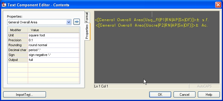
I just label a closed polyline on any one of the segments and the label returns the area. I've configured it for square feet and acres. I used the General Overall Area variable to create it.
I'm not sure what you're getting at with the tag number. In the Label Style Composer, in the Tabel Tag group, I suspect you may have the "Used In" setting set to "Label and Tag Modes" instead of just "tag mode":
I'll try to attach screen shots of the settings I used.
Message 16 of 17
04-17-2012
09:34 AM
- Mark as New
- Bookmark
- Subscribe
- Mute
- Subscribe to RSS Feed
- Permalink
- Report
04-17-2012
09:34 AM
Here is an old (but still good) post using line labels for elevations. At the end, I have an example using a line area label for silt fence.
http://civil3drocks.blogspot.com/2006/06/label-style-for-calling-out-elevation.html
Dana Probert, P.E.
Technical Marketing Manager, Civil Engineering
Autodesk
Blog: BIM on the Rocks
Learn More About BIM for Infrastructure
Technical Marketing Manager, Civil Engineering
Autodesk
Blog: BIM on the Rocks
Learn More About BIM for Infrastructure
Message 17 of 17
04-17-2012
03:34 PM
- Mark as New
- Bookmark
- Subscribe
- Mute
- Subscribe to RSS Feed
- Permalink
- Report
04-17-2012
03:34 PM
I've been getting frustrated in C3D 2011/2012 by the fact that some Parcel curve labels have incorrect deltas... Seems to happen most when using large coordinate values, such as ones related to State Plane. I think it's created by a precision error, which causes C3D Parcels to include erroneous extra very tine curve segments (with 0.000 length, but a delta angle) that gets "added" to the value shown in the label. Very disturbing, since it can cause plats to show incorrect delta angles in curves, and the problem is very hard to catch.
Just really confused by how I never had this problem in C3D 2010 and earlier...
Sinc
Reply
Topic Options
- Subscribe to RSS Feed
- Mark Topic as New
- Mark Topic as Read
- Float this Topic for Current User
- Bookmark
- Subscribe
- Printer Friendly Page

