Community
Civil 3D Forum
Welcome to Autodesk’s Civil 3D Forums. Share your knowledge, ask questions, and explore popular AutoCAD Civil 3D topics.
Turn on suggestions
Auto-suggest helps you quickly narrow down your search results by suggesting possible matches as you type.
Reply
Topic Options
- Subscribe to RSS Feed
- Mark Topic as New
- Mark Topic as Read
- Float this Topic for Current User
- Bookmark
- Subscribe
- Printer Friendly Page
Message 1 of 12
08-05-2013
07:11 AM
- Mark as New
- Bookmark
- Subscribe
- Mute
- Subscribe to RSS Feed
- Permalink
- Report
08-05-2013
07:11 AM
Afternoon,
Best way (if any) of creating bas relief images in Civil 3D?
We tend to use QGIS for this sort of thing normally but I'd rather be able to create a grey bas relief-style surface in Civil 3D so I can overlay it with other data, labels etc. The data sets we use are quite large, LiDAR down to 50cm grids over a few kilometres.
Preferably quick ie. stay clear of setting up light sources etc. . I can kind of get something similar in object viewer with the (50) shades-of-grey setting but it isn't particularly good for straight overhead views.
Am on 2013 SP2, Win 7.
Ta,
Kevin
Solved! Go to Solution.
Solved by john.mckenzie. Go to Solution.
11 REPLIES 11
Message 2 of 12
08-05-2013
07:30 AM
- Mark as New
- Bookmark
- Subscribe
- Mute
- Subscribe to RSS Feed
- Permalink
- Report
08-05-2013
07:30 AM
can you provide a small screen shot of what you are trying to accomplish?
Message 3 of 12
08-05-2013
07:47 AM
- Mark as New
- Bookmark
- Subscribe
- Mute
- Subscribe to RSS Feed
- Permalink
- Report
08-05-2013
07:47 AM
Are you trying to improve contrast between images and CAD linework?
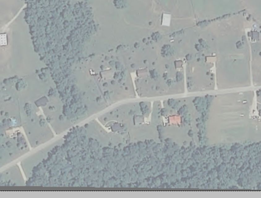
We often use an orthographic image as a basemap.
usually we do this on coversheets or to supplement limited field survey. there are various instances where this is helpful.
In order to use these images with decent clarity of other linework, we utilise the image adjustment tools.
Pick the image and right click.
Jp2 images allow Brightness, contrast, and fade adustments.
We usually stick to the colr orthos but I would think this is possible with grescale ones as well.
I know that different image formats allow different adjustments so your resluts may vary.
Message 4 of 12
08-05-2013
07:53 AM
- Mark as New
- Bookmark
- Subscribe
- Mute
- Subscribe to RSS Feed
- Permalink
- Report
08-05-2013
07:53 AM
capture is the orig.
capture fade is the modified one.
Message 5 of 12
08-05-2013
07:54 AM
- Mark as New
- Bookmark
- Subscribe
- Mute
- Subscribe to RSS Feed
- Permalink
- Report
08-05-2013
07:54 AM
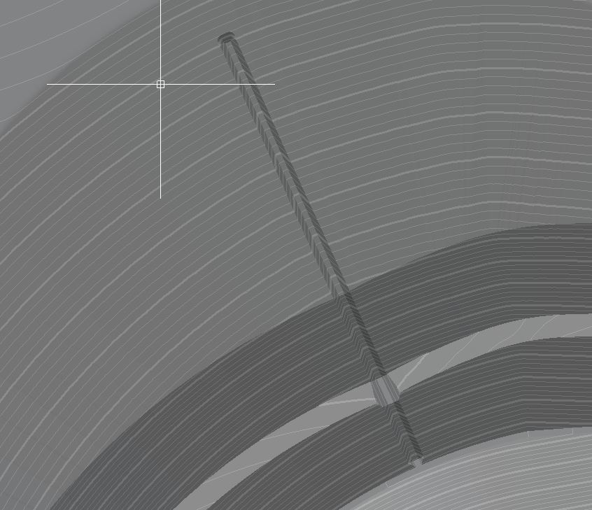
Here's a non-particularly good example of bas relief on lidar data. I'll try and dig out a better one.
Kevin
Message 6 of 12
08-05-2013
07:58 AM
- Mark as New
- Bookmark
- Subscribe
- Mute
- Subscribe to RSS Feed
- Permalink
- Report
Message 7 of 12
08-05-2013
08:07 AM
- Mark as New
- Bookmark
- Subscribe
- Mute
- Subscribe to RSS Feed
- Permalink
- Report
08-05-2013
08:07 AM
We'll often have this in the background, with aerial imagery plus a variety of contours, elevation maps and cad linework on top. It's really good for seeing the overall topography and directions of slopes.
The annoying thing for me is that I have to create the bas relief in a separate package then bring the image back in to Civil 3D, even though it's exactly the same data.
Any thoughts?
Kevin
Message 8 of 12
08-05-2013
08:42 AM
- Mark as New
- Bookmark
- Subscribe
- Mute
- Subscribe to RSS Feed
- Permalink
- Report
08-05-2013
08:42 AM
So you can use the shades of grey if you want to. (view style I mean)
Go to your surface style and set your slope analysis to mesh and exagerate the vertical scale to acheive whatever degree of contrast you need for the bas-relief. you can use the shades of grey or conceptual or realistic view styles. Each with varying degrees of processing ooompfh required.
this will have some significant overhead relative to graphics processing but I imagine what you do now does also.
Message 9 of 12
08-05-2013
08:51 AM
- Mark as New
- Bookmark
- Subscribe
- Mute
- Subscribe to RSS Feed
- Permalink
- Report
08-05-2013
08:51 AM
Remember that this is not an image any longer but a dynamic surface representation. You may need a supercomputer to use this method in production unless you can turn it on only when you absolutely need it. I will post a visual snip of what you can achieve in a moment.
Message 10 of 12
08-05-2013
09:11 AM
- Mark as New
- Bookmark
- Subscribe
- Mute
- Subscribe to RSS Feed
- Permalink
- Report
08-05-2013
09:11 AM
This seems to work and I'll play about with it - but I think you're right in terms of performance. Generating it by QGIS takes 30 seconds and the exported image is georeferenced and much easier to deal with in CAD than a fully dynamic surface.
Setting the working viewport style to shades of grey with a vertical exaggeration of 5 produces a really nice and detailed relief but takes about 10 seconds to pan/zoom 1 step and there appear to be issues with ordering, drawing on top, raster transparencies etc.
See attached for a cad version.
Nice idea though!
Kevin
Message 11 of 12
08-05-2013
09:25 AM
- Mark as New
- Bookmark
- Subscribe
- Mute
- Subscribe to RSS Feed
- Permalink
- Report
08-05-2013
09:25 AM
This is a surface of a landfill design.
It looks good with an exageration.
I often use this type of visualization when I want to show something in a flashy way.
I have the exagerated slopes going to a layer with a 25 percent transparency. I have my design contours greyed but solid and you can see the differing slopes by shaded greys.
I could have the entire landfill shown with the existing surface on in a greenish representation for slopes and contours allowing me to represent the design with existing in 2d but with a bit or visual relief hocus pocus.
C3d can do wonderful things.
How much horsepower do you have and how much time.
this is with 16gb ram and a 2gb graphics card running on a laptop with 64bit CAD and 3ghz quad processing (guessing at the 3 ghz) I can pan almost real time.
Message 12 of 12
08-05-2013
09:52 AM
- Mark as New
- Bookmark
- Subscribe
- Mute
- Subscribe to RSS Feed
- Permalink
- Report
08-05-2013
09:52 AM
Looks good - we do something similar. I find bas relief imagery to be great for LiDAR representations of topography as opposed to contours and elevations. Believe it or not, we present to some people who find contours difficult to read or interpret.
I've got a desktop i7-3770 @ 3.4GHz, 8 cores, .16Gb RAM, Win7 64bit. GFX is a 2Gb ASUS HD7770. A decent system but Civil 3D still drags as it's not multicore capable.
Kevin
Reply
Topic Options
- Subscribe to RSS Feed
- Mark Topic as New
- Mark Topic as Read
- Float this Topic for Current User
- Bookmark
- Subscribe
- Printer Friendly Page

